• About The Project
  • Palestine in Century
  • Selected Maps
  • Glossary
  • About ARIJ
  • About LRC
  • By Year
    • Case Studies By Year
    • Daily Report By Year
Tuesday, August 12, 2025
POICA
No Result
View All Result
  • Home
  • Settlements
    • New Israeli Settlements
    • Settlement Expansion
  • Israeli Violations
    • Agriculture
    • Confiscation
    • Demolition
    • Environment
    • Eviction of Palestinians
    • Settlers Attacks
  • Bypass Roads
  • Israeli Plans
  • Segregation
    • Checkpoints
    • Closure
    • Separation Plans
  • Military Orders
  • Reports
    • Daily Report
    • Monthly Report
    • Quarterly Report
No Result
View All Result
POICA
No Result
View All Result

The Israeli Occupation targets the village of Qatanna

June 19, 2008
in Israeli Violations
The Israeli Occupation targets the village of Qatanna

Overview

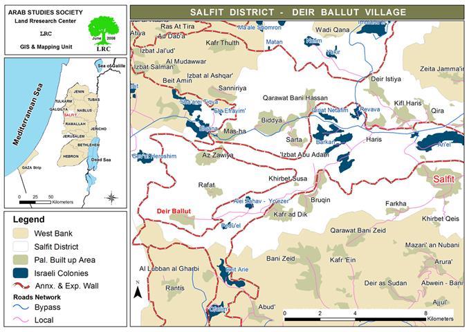
Qatanna, a Palestinian village located 12 Kilometers to the northwest of the Jerusalem, has an area of 3793 dunums and is 650 meters above sea level. The village population is currently around 7496 (PCBS 2006) with 373 dunums of built-up area. Qatanna is surrounded by the Palestinian villages of Qibya and Beit ‘Anan form the north, the Illegal Israeli settlement of Har Adar from the south, the Israeli Apartheid Segregation Wall from the south and the west, and by Biddu village from its east.


In accordance with Oslo II Interim Agreement that was signed in September 1995 between the PLO (Palestinian Liberation Organization) and Israel,  the Palestinian areas in the West Bank were categorized into three areas A (where the Palestinians have control over administrative and security issues), B (Palestinians have full control over the civil responsibilities and Israel continues to have overriding responsibility for security) and C (Israel retains full control over security and administration related to territory). Accordingly, a total of 716 dunums of Qatanna’s lands were classified as Area B; while a total of 3077 dunums were classified as Area C. See the map below:


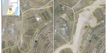
Map 1: Map of Qatanna Village


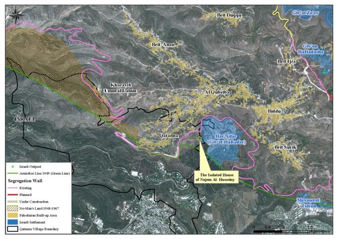
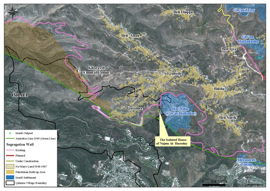
Qatanna & the Apartheid Wall

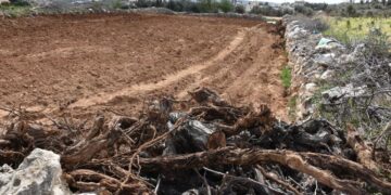
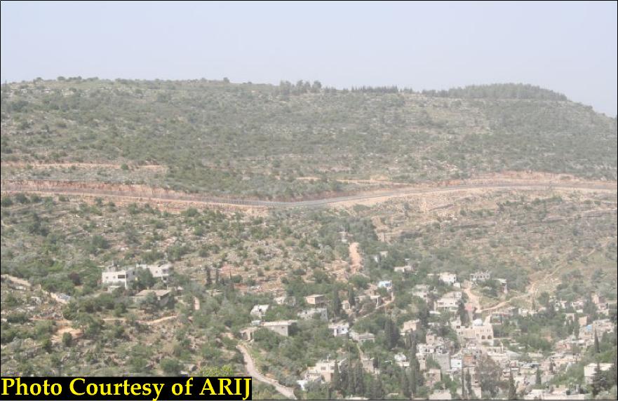
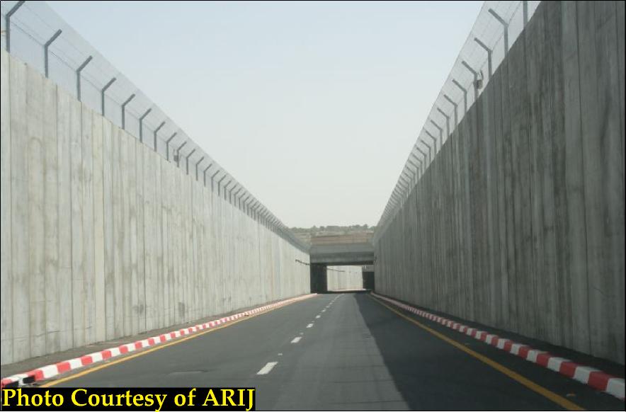
On December 9, 2003, the Israeli forces handed the residents of Qatanna military order holding number (84/03/T) to confiscate 192.2 dunums of lands from the their village, as well as from Al Qubeiba, in order to construct the 'Segregation Wall', of which 106 dunums are located within Qatanna's village boundary. Moreover, another military order holding number (107/03/T) was issued by the Israeli occupation on December 31, 2003, to confiscate 238.4 dunums of lands from Qatanna, Biddu, Beit Surik and Al Qubeiba villages, whereby 47 dunums of them are to be taken from Qatanna's land. The Segregation Wall in Qatanna village reaches a length of 6 Kilometers, isolating 47% from the total village’s lands. See photo 1 & Photo 2:


The table below shows the land classification inside the village boundary and the lands that will be isolated behind the Wall

Land Use/Land Cover in Qatanna Village

Land Classification of Qatanna Village

LULU of Qatanna Village

LULC of Isolated lands in Qatanna Village

Percentage of land isolated by the Wall

Agricultural lands

910

105

3

Forests and Open Spaces

2301

1575

42

Palestinian built-up area

373

3

0

Israeli Settlement

62

59

2

Wall Zone

147

122

3

Total Area

3793

1864

49

Source: ARIJ GIS Database 2007


Moreover, the 144 m² house of Najem El Din Taher Al Husseini, which is adjacent to Har Adar Illegal Israeli settlement, constructed in the year 1986 on 69 of dunums of Qatanna’s lands, is located on the eastern edge of the village and will be totally isolated behind the Wall path. The 19 family members will no longer have access to the village. This house was constructed in 1972 and contains 4 rooms, a kitchen and a bathroom. Today, the Israeli forces cut the water supply to the house of Najem El Din and nobody can enter the Iron Gate except Najm El Din's family in an attempt to cut them out of the external world and to force then to leave their house. See Photos below:


Furthermore, the Israeli occupation forces prohibits him from building any additional units or constructions to the house and rejects paving or letting him pave the only street leading to the house. It is also worthwhile to point out that this house is threatened to either be demolished or to be attached to the nearby Israeli settlement of Har Adar due to its proximity to the settlement.


Water Problem in Qatanna


Not only have the lands of Qatanna been confiscated by the Israeli occupation, but also the water supply of the village is being confiscated by the Israeli settlers of the Illegal Israeli settlement of Har Adar (est. 1986, pop. 2400 settlers).


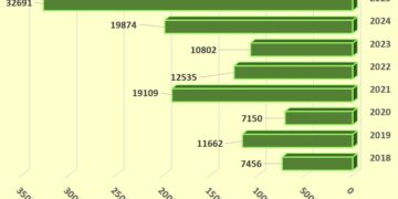
It is worth mentioning that the main water tank which provides Qatanna village with water supply is located in the aforementioned Israeli settlement where an Israeli company called “Mikrot” controlling the timing and amount of water flow  to Qatanna and another seven Palestinian villages through an 4“ water pipeline. See chart below:


Accordingly, the residents of Qatanna villages as well as the nearby villages are facing a dramatic scarcity of water, where all of the residents of Qatanna village (approximately 8000) had received only 72,420 cubic meter of water during a period of 4 months, meaning that every single family in Qatanna village will receive water only three days a month.


The Israeli government continues to create more obstructions to peace through many different actions such as demolishing the Palestinian houses, confiscating more lands for constructing, expanding the Illegal Israeli settlements and the Apartheid Segregation Wall and even confiscation of the water resources not only in Qatanna village but in all of the occupied West Bank as well.


Prepared by 
The Applied Research Institute – Jerusalem


Recommended For You

Villages and Communities of Masafer Yatta: A Model of the Forced Displacement of Palestinian Communities in Area “C”

by arij
August 2, 2025
0
Villages and Communities of Masafer Yatta: A Model of the Forced Displacement of Palestinian Communities in Area “C”

Introduction: Since its occupation of the West Bank in 1967, Israel has pursued a long-term policy aimed at minimizing Palestinian presence in Area “C”, which constitutes approximately 61%...

Read moreDetails

قرى وتجمعات مسافر يطا: نموذج تهجير التجمعات الفلسطينية في المنطقة “ج” سياسة ممنهجة لاقتلاع الوجود الفلسطيني

by arij
August 6, 2025
0
قرى وتجمعات مسافر يطا: نموذج تهجير التجمعات الفلسطينية في المنطقة “ج” سياسة ممنهجة لاقتلاع الوجود الفلسطيني

مقدمة: منذ احتلالها للضفة الغربية عام 1967، تنتهج إسرائيل سياسة طويلة الأمد تهدف إلى تقليص الوجود الفلسطيني في المناطق المصنفة "ج"، التي تشكل ما نسبته 61% من الضفة...

Read moreDetails

قرية النعمان ضحية خطوة تهويديه أخرى: بلدية القدس الإسرائيلية تستهدف ديمغرافيا الوجود الفلسطيني

by arij
August 6, 2025
0

في خطوة تصعيدية جديدة ضمن سلسلة من الإجراءات التهويدية، أخطرت سلطات الاحتلال الإسرائيلي بتاريخ الثلاثين من تموز 2025 كافة منازل قرية النعمان الواقعة شمال شرق بيت لحم وجنوب...

Read moreDetails

Nu’man Village: A Victim of another Judaization Campaign

by arij
August 2, 2025
0
Nu’man Village: A Victim of another Judaization Campaign

In a new escalation within a systematic Judaization campaign, Israeli municipality of Jerusalem issued mass demolition orders on July 30, 2025, targeting all homes in the village of...

Read moreDetails

في حضرة العنف, “المواطن الفلسطيني بين بندقية المستوطن وجرافة الاستيطان”

by arij
August 4, 2025
0
في حضرة العنف, “المواطن الفلسطيني بين بندقية المستوطن وجرافة الاستيطان”

مقدمة: يوما بعد يوم، وعاما بعد عام، يتكرر المشهد ذاته في الضفة الغربية المحتلة، عنف الى اعلى المستويات، واعتداءات مستوطنين لا تتوقف، وصمت دولي أمام المعاناة اليومية للمواطنين...

Read moreDetails
Next Post
New house demolition orders in Deir Ballut village

New house demolition orders in Deir Ballut village

LATEST NEWS

Escalation and forced displacement in Kisan

by arij
August 6, 2025
0

........................................................

بؤرة استيطانية جديدة وتهجير قسري في كيسان

by arij
August 6, 2025
0

........................................................

Villages and Communities of Masafer Yatta: A Model of the Forced Displacement of Palestinian Communities in Area “C”

Villages and Communities of Masafer Yatta: A Model of the Forced Displacement of Palestinian Communities in Area “C”

by arij
August 2, 2025
0

........................................................

قرى وتجمعات مسافر يطا: نموذج تهجير التجمعات الفلسطينية في المنطقة “ج” سياسة ممنهجة لاقتلاع الوجود الفلسطيني

قرى وتجمعات مسافر يطا: نموذج تهجير التجمعات الفلسطينية في المنطقة “ج” سياسة ممنهجة لاقتلاع الوجود الفلسطيني

by arij
August 6, 2025
0

........................................................

flag_yellow_lowEU-PfP-Logo

This website has been produced with the assistance of the European Union. The contents of this publication are the sole responsibility of ARIJ & LRC and can in no way be taken to reflect the views of the European Union.

© 2025 Copyright ARIJ . All Rights reserved. .

No Result
View All Result
  • Home
  • Settlements
    • New Israeli Settlements
    • Settlement Expansion
  • Israeli Violations
    • Agriculture
    • Confiscation
    • Demolition
    • Environment
    • Eviction of Palestinians
    • Settlers Attacks
  • Bypass Roads
  • Israeli Plans
  • Segregation
    • Checkpoints
    • Closure
    • Separation Plans
  • Military Orders
  • Reports
    • Daily Report
    • Monthly Report
    • Quarterly Report

© 2025 Copyright ARIJ . All Rights reserved. .