• About The Project
  • Palestine in Century
  • Selected Maps
  • Glossary
  • About ARIJ
  • About LRC
  • By Year
    • Case Studies By Year
    • Daily Report By Year
Saturday, May 10, 2025
POICA
No Result
View All Result
  • Home
  • Settlements
    • New Israeli Settlements
    • Settlement Expansion
  • Israeli Violations
    • Agriculture
    • Confiscation
    • Demolition
    • Environment
    • Eviction of Palestinians
    • Settlers Attacks
  • Bypass Roads
  • Israeli Plans
  • Segregation
    • Checkpoints
    • Closure
    • Separation Plans
  • Military Orders
  • Reports
    • Daily Report
    • Monthly Report
    • Quarterly Report
No Result
View All Result
POICA
No Result
View All Result

Israeli Occupation Forces closes the Northern Entrance of the Azzun Al Shamaliyya town

February 20, 2008
in Closure
Israeli Occupation Forces closes the Northern Entrance of the Azzun Al Shamaliyya town

Type of Violation: Closing the main entrance of a Palestinian Village with roadblocks and sand.


Location of Violation: Azzun Al Shamaliya village's main entrance located parallel to the Israeli bypass Road number 55 which connects the colony of Kedumim with the 1949 Armistice Line (Green Line).


Cause of Violation: Preventing Azzoun Town, Sanniriyia and Kafr Thuluth villages' residents from using Bypass Road 55 to allow the exclusive Israeli use of the road.     


Date of Violation: February 8th, 2008.


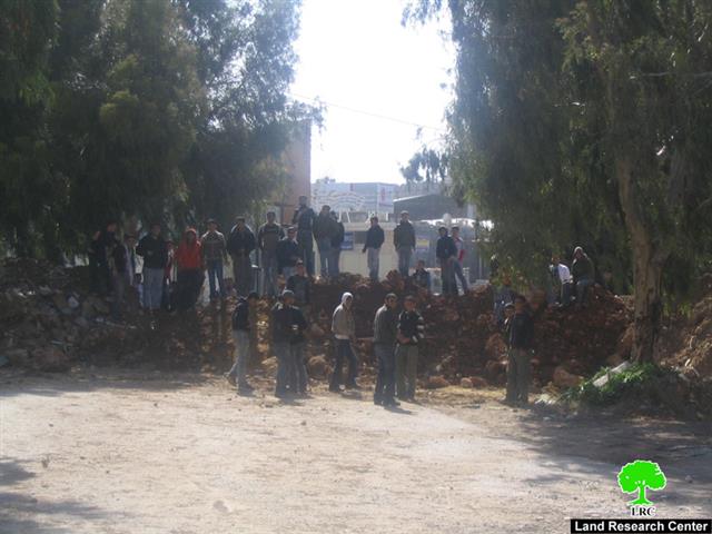
(Photo 1: The northern entrance of Azzoun town after its
closure by Israeli occupation authorities
) 


The Violation: The Israeli Occupation Forces closed with road blocks and earth mounds the northern entrance of Azzun Al Shamaliya town and caused damages to the Infrastructure of the road. The impacts of the closure upon Palestinians include the following:

  • The entrance is considered the linkage between the villages and towns of Kufr Thulth and Azzun Al Shamaliya in Qalqilyah Governorate with Sanniryia village in Nablus Governorate. Upon the closure of the entrance, the Palestinian access to the nearby Palestinian communities became more difficult and Palestinians are forced to go to the nearby village of 'Asla (located west of Azzoun Al Shamaliya), then to the village of Izbatt Al Tabib before accessing their desired destination. Such route adds financial and physical burdens on Palestinians as the new route is longer in distance, time consuming and costly.

  • Due it's location close to the Israeli Bypass Road 55, the town of Azzun was the preferred destination for merchants and investors from inside the 1949 Armistice Line (Green Line) who come to shop in the town, most especially on Saturdays. The closure is expected to obstruct the commercial exchange line which in turn will affect the economy of the town as such, poverty and unemployment levels in the town are expected to increase due to the closure.

The Israeli occupation forces claim that the closure of Azzun's town main entrance came for security reasons, mainly to protect Israeli settlers using Bypass Road 55 from to access their destinations. It should be noted here that it is not the first time that Israeli occupation forces have closed this entrance; such a closure took place many times during the period of 2004 and 2007. As for the period between 2000 and 2003, the entrance was completely closed with cement blocks and earth mounds which severely obstructed the daily lives of Palestinian residents of the eastern and western villages of Qalqilyah Governorate. In addition, death cases and baby delivery cases were reported as Palestinian were forced to use longer routes to reach the nearest medical centers.


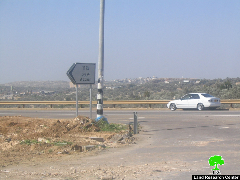
(Photo 2: The northern entrance of Azzun town
is close to the colonial road no '55'
)


General Information about Azzoun:

Location: Azzun town is located on the road linking Nablus and Qalqilyah cities together, known as Bypass Road 55. It is located 23 kilometers west of Nablus city, 9 kilometers east of Qalqilyah city and 22 kilometers to the south of Tulkarem city. It is also connected to the city of Ramallah with a paved road leading southward to the villages of Kafr Thuluth, Mas-ha, Deir Ballut and Bir Zeit villages. As such, Azzun is at the center of a large number of villages and towns:

  • Northwards: the villages of Jayyous, Seir, Kufr Jamal, Kufr Abboush, Kufr Zibad and Kufr Sur.

  • Southward: Kufr Thilith, Sneiria, Masha, Bidya and Al Zawiya.

  • Westward: Al Nabi Ilyas, Asla.

  • Eastwards: Kufr Laqif, Jinsafout, Hijja, Baqat Al Hatab, Amatein, Farâ��ata, Jeit, Kufr Qaddoum and Al Sirra.

Area and Population: The total area of Azzun is about 24,000 dunums. It is bordered by the city of Qalqilyah and the village of Habla from the west while its lands reach the villages of Kafr Laqif and Deir Istiya in the east. The forest of Azzun (renamed the Ra�nana forest after the 1948 Nakba) is the western limit of the lands of Azzun. It is worth noting here that Azzun town lost a large portion of its lands during the 1948 war where the original area of the town totaled 24,000 dunums at the time, while the current total town area is 9,139 dunums, out of which 1209 dunums are designated for the built up area of the town.


The town is a home to 9,349 Palestinians (PCBS 2006), of which, 40% work in agriculture and herding which constitute the main source of income, 19% of the total population works in public services while the remaining population work in handicrafts and trade. The unemployment rate in the town stands at 19%.


Israeli Colonial Activity: Three Israeli colonies work on the lands of Azzun Town, they are:

  • Maâ��ale Shomron: established in 1980 and occupies a total area of 1903 dunums. The urban area of the village is 26 dunums and is a home to 600 Israeli settlers â�� Pop 2006.

  • Ginot Shomron: established in 1985 with a building surface area of 484 dunums.

  • Karni Shomron: established in 1978 with a total area of 7,339 dunums. Building surface area is about 1,351 dunums with a total of 6,270 colonists living in it according to 2005 statistics.


Prepared by
The Land Research Center
LRC

Recommended For You

Israel tightens the Grip on Nablus Governorate –  الحصار يخنق محافظة نابلس 

by arij
October 20, 2022
0
Israel tightens the Grip on Nablus Governorate –  الحصار يخنق محافظة نابلس 

  The map of Israeli checkpoint stifling the daily life of more than 388 thousand Palestinians   الحصار يخنق محافظة نابلس  The Israeli Closure Policy in International Law The...

Read moreDetails

الاحتلال الإسرائيلي يغلق مدخل بلدة سلواد الجنوبي في محافظة رام الله والبيرة

by arij
November 7, 2022
0
الاحتلال الإسرائيلي يغلق مدخل بلدة سلواد الجنوبي في محافظة رام الله والبيرة

  الانتهاك: اغلاق طريق بالسواتر الترابية. الموقع: بلدة سلواد/ محافظة رام الله والبيرة. تاريخ الانتهاك: 06/10/2022م. الجهة المعتدية: جيش الاحتلال الاسرائيلي. الجهة المتضررة: أهالي بلدة سلواد. تفاصيل الانتهاك:...

Read moreDetails

إغلاق مدخل بلدة قصرة الرئيسي / محافظة نابلس

by arij
September 28, 2022
0
إغلاق مدخل بلدة قصرة الرئيسي / محافظة نابلس

  الانتهاك: إغلاق طريق. الموقع:بلدة قصرة جنوب مدينة نابلس. تاريخ الانتهاك:13 أيلول 2022م. الجهة المعتدية:جيش الاحتلال الإسرائيلي. الجهة المتضررة:أهالي بلدة قصرة والقرى المجاورة. تفاصيل الانتهاك: اقتحمت قوة كبيرة من...

Read moreDetails

Closure of the main iron gate entrance of Aboud village, Ramallah governorate

by arij
July 4, 2022
0
Closure of the main iron gate entrance of Aboud village, Ramallah governorate

  Violation: Closing the main entrance to the village. Location: Aboud village / Ramallah and Al-Bireh governorate. Violation date: 09/06/2022 AD. Perpetrators: The Israeli Occupation Army. Affected party:...

Read moreDetails

إغلاق المدخل الرئيسي بالبوابة الحديدية في قرية عابود بمحافظة رام الله

by arij
July 2, 2022
0
إغلاق المدخل الرئيسي بالبوابة الحديدية في قرية عابود بمحافظة رام الله

  الانتهاك: إغلاق المدخل الرئيسي بالبوابات الحديدية. الموقع: قرية عابود/ محافظة رام الله والبيرة. تاريخ الانتهاك: 09/06/2022م. الجهة المعتدية: جيش الاحتلال الاسرائيلي. الجهة المتضررة: سكان قرية عابود. تفاصيل...

Read moreDetails
Next Post
14 مقطع يكون جدار العزل الإسرائيلي  يعزل 64 تجمع فلسطيني يقطنها أكثر من 107 ألف فلسطيني و يضم 107 مستوطنة إسرائيلية يقطنها قرابة ال 400 ألف مستوطن اسرائيلي

14 مقطع يكون جدار العزل الإسرائيلي
يعزل 64 تجمع فلسطيني يقطنها أكثر من 107 ألف فلسطيني و يضم 107 مستوطنة إسرائيلية يقطنها قرابة ال 400 ألف مستوطن اسرائيلي

LATEST NEWS

الأراضي الفلسطينية بين الذرائع الأمنية والأطماع الاستيطانية – “الأمن، الآثار، والطبيعة كحجج لاقتلاع الفلسطينيين من أراضيهم”

by arij
April 15, 2025
0

........................................................

الطرق الالتفافية الاسرائيلية وأثرها على البيئة الفلسطينية

انتهاك للطبيعة والهوية في الأراضي الفلسطينية المحتلة

by arij
March 17, 2025
0

........................................................

Israel Advances Settlement Plan on Ancient Olive Groves on lands of Beit Jala city, Violating International Law and depriving Palestinians their lands

إسرائيل تمضي قدمًا في مخطط استيطاني جديد على أراضي مدينة بيت جالا، في انتهاك للقانون الدولي وحرمان الفلسطينيين من أراضيهم

by arij
April 29, 2025
0

........................................................

Israel Advances Settlement Plan on Ancient Olive Groves on lands of Beit Jala city, Violating International Law and depriving Palestinians their lands

Israel Advances Settlement Plan on Ancient Olive Groves on lands of Beit Jala city, Violating International Law and depriving Palestinians their lands

by arij
April 29, 2025
0

........................................................

flag_yellow_lowEU-PfP-Logo

This website has been produced with the assistance of the European Union. The contents of this publication are the sole responsibility of ARIJ & LRC and can in no way be taken to reflect the views of the European Union.

© 2025 Copyright ARIJ . All Rights reserved. .

No Result
View All Result
  • Home
  • Settlements
    • New Israeli Settlements
    • Settlement Expansion
  • Israeli Violations
    • Agriculture
    • Confiscation
    • Demolition
    • Environment
    • Eviction of Palestinians
    • Settlers Attacks
  • Bypass Roads
  • Israeli Plans
  • Segregation
    • Checkpoints
    • Closure
    • Separation Plans
  • Military Orders
  • Reports
    • Daily Report
    • Monthly Report
    • Quarterly Report

© 2025 Copyright ARIJ . All Rights reserved. .