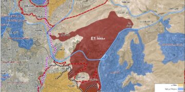
In November 2007, the Israeli Occupation Authorities started razing lands in the villages of Marda and Kifl Haris west of Salfit Governorate with the aim of completing the construction of a road that connects with Trans-Samaria Road (Bypass Road number 5) (a road emerging from the junction of Bypass Road 55 and 5 with Ariel settlement's entrance). The Road which extends at a length of 5 kilometers and 100 meters wide will run parallel to Bypass Road 55.
It is worth mentioning that Israeli Occupation Authorities started working on this section of the road back in 2002 when vast areas of land were razed from Marda and Kifl Haris villages. Work was then frozen until after the Annapolis Meeting when the Israeli Authorities again decided to resume construction work on this section of the road.

(Photo 1: Israeli Bulldozers preparing for the construction of the colonial road)
Road 5:
Trans-Samaria Road 5 is being constructed as an alternative to Road 505 to be used by Israeli settlers connecting them with settlements inside the 1949 Armistice Line (Green Line). Its construction is taking place in accordance with the unilateral disengagement scheme adopted recently by the Israeli Occupation Authorities. Its establishment is taking place in three phases:
-
The first phase was embarked upon at the beginning of the second intifada in September 2000. This section of Road 5 connected with Road 55 at Kifl Haris junction east of Salfit Governorate and continued until it reached the settlement of Ras Al 'Ein inside the 1949 Armistice Line (Green Line) west of the Governorate. The Bypass Road section extends for a length of 14 kilometers with a varying width ranging between 100 to 180 meters. The establishment of the first phase has led to the destruction of about 1400 dunums of lands used to be planted with Old Roman Olive Trees. Moreover, lands located at a distance of 150 meters on either side of the road were declared as 'Closed Military Areas' which made Palestinian lives a living hell with the increasing levels of suffering, agony and poverty.


Photo 2 & Photo 2B: Kilf Haris village witnessing the loss of its lands for the
construction of the new section of the Israeli Bypass Road )
-
The second phase started only recently following Annapolis Meeting in November 2007. This phase will include the construction of another section of the road starting at the Kifl Haris junction (more specifically at the intersection of Road 55 and Road 5) and reaching Ariel settlement's entrance. This section extends in parallel with Bypass Road 55.
-
As for the third phase, it is planned to start in 2010 and will include the construction of another road section extending from Ariel settlement's entrance and continues eastward in the direction of Za�atara checkpoint.
The overall goal behind the construction of Bypass Road 5 is to replace Bypass Road 55 connecting between the colonies of Ariel, Peduel, Eli Zahav and Burqan.
The Negative impacts of Road 5 on Palestinians
The construction of the second phase of Bypass Road 5 will lead to the destruction of more than 500 dunums of Palestinian agricultural lands located beneath the Road. It will also lead to the isolation of no less than 120 dunums in the area located between the new bypass Road (Road Number 5) and the old Bypass Road number 55. More than 5000 olive trees have been uprooted so far to make way for the construction of the bypass Road which, upon its completion, will cause a deterioration in the economic situation of land owners and other Palestinian families in the area.
Upon the constructing the Road, Israeli Occupation Forces closed down the main entrance of Kifl Haris village which is considered to be the main passageway for residents of Kilf Haris village (total area = 9528 dunums, out of which, 1070 dunums constitute the built-up where 3,132 people live � PCBS 2005) and Qira village (total area = 2080 dunums, out of which, 212 dunums constitute the built-up area where 1020 people live, PCBS-2005). Such a restriction on movement was reflected negatively on the lives of Palestinians of the two villages as transportation costs increased while physical and psychological burdens became heavier day by day.
In addition, the construction of the new Road section has hit the Palestinians hard as their lands have been confiscated and their houses will be threatened by the existence of this bypass Road. It is also expected that harassments by the Israeli occupation army will increase under the pretext of providing security for the Israeli settlers using the Road.

Photo 3:The main gate of kufel Hares closed by the Israel ARMY
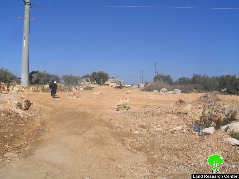
Photo 4: Kufel Hares people walking after the closer of the gate
Colonial By-Pass Roads in Salfit Governorate:
By-pass roads constructed by the Israeli Occupation Authorities around the Governorate of Salfit is one example of the Israeli Separation Policy that aims at disconnecting Palestinian villages and towns from each other while at the same time connecting Israeli settlements inside the West Bank Territory with each other and with those inside the 1949 Armistice Line (Green Line). In Salfit Governorate, 6 Israeli bypass roads carve the lands of Palestinians, they are:
-
Trans-Samaria Road 505 which stretches westward from the 1949 Armistice Line (Green Line) until Za�atara checkpoint junction east of the Governorate. The Road passes by a number of Palestinian villages and towns in the Governorate including Mas-ha, Al Zawiya, Bidya, Kifl Haris, Marda and Yasuf. The road extends for a length of 20 kilometers with a width of 100 meters (including banks of the Road). The section of the Road passing by the village of Mas-ha has been closed since the eruption of the second intifada in September 2000. As such, the movement of Israeli settlers coming from inside the 1949 Armistice Line (Green Line) was diverted to Trans-Samaria Road 5.
-
Trans-Samaria Road 5 which Israeli Occupation Authorities inaugurated its construction in year 2000 as a replacement for bypass Road 505. The new Road commences at and connects with the old one running from Kifl Haris junction and ends at Ras Al 'Ein settlement inside the 1949 Armistice Line (Green Line). The length of the Road is 14 kilometers with a width ranging between 100 and 180 meters.
-
Road 60: a small portion of this road runs through the Governorate, on lands of Yafuf village and reaching Za�atara checkpoint. The length of this road section is 3 kilometers with a width of 80 meters. This Road is the considered the main connection between the governorates of Nablus and Ramallah.
-
Road 5066, also known as Qana Valley Road. The Road starts from Kifl Haris junction and then extends northwards cutting through the lands of Deir Istiya village until it reaches the junction Jinsafut village in Qalqilyah Governorate. The Road extends for a length of 10 kilometers with a width of 80 meters. It runs through the fertile lands of the Governorate as it connects 4 Israeli Settlements (Immanuel, Revava, Nofim and Yakir) with each other along with a number of outposts scattered in its vicinity. Palestinians were prohibited from using this Road since the eruption of the second current intifada until the beginning of year 2004 when they were again allowed to use it.
-
Road 446: Palestinians are not allowed to use this road. It used to connect the settlements of Peduel and Eli Zahav in Salfit Governorate with the settlements of Beit Arye in Ramallah Governorate and those inside the 1949 Armistice Line (Green Line) as well connecting these settlements with Trans-Samaria Road 5 eastwards. Only a section of this Road is located within the Governorate of Salfit and cuts through the lands of Bruqin and Kafr Al Diek villages until it reaches Deir Balut checkpoint west of the Governorate. The length of this road section is about 8 kilometers with a width ranging between 60 and 80 meters.
-
Road 4775: It leads to the settlement of Ariel in the north and is considered to be the connection between Ariel Settlement and Trans-Samaria Road number 505. Palestinians were prohibited from using the Road since the beginning of the second intifada in September 2000 and was closed with cement cubes and earth mounds. Before that, this road was used as a passage way to Salfit city from its northeastern direction. The length of this Road is 3 kilometers with a width of 80 meters.

Photo 5:Settler's road No '505'

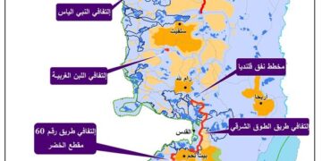
Map 1; Colonial road No '5'
Prepared by
The Land Research Center
LRC