
Photo 1: Hamra military checkpoint is one of 6 checkpoints separating
between the Ghor and West Bank
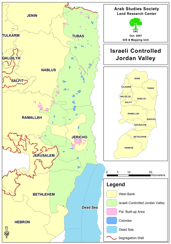
Background
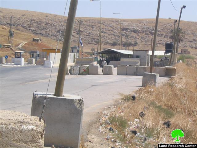
The Ghor ( Jordan valley) total original area is about 433 KM2 ( approximately 7.6% of the total area of the West Bank). The Ghor area expands from the Dead Sea until the northern borders of the West Bank in Tubas governorate. According to Oslo agreements that were signed between the PLO and Israeli in 1993 in Washington the city of Jericho and Al Ouja village lie in zone A which is under total Palestinian security and civic affairs while the remaining areas (about 90% of the Ghor) are classified as zones B or C which are under Israeli security affairs.
Map 1: the original land area of the Ghor (in blue color) before being
extended by the occupation authorities
There are 17 Palestinian residential areas in the Ghor in which more than 51500 Palestinians settle, 60% of whom are centered in the city of Jericho and surrounding refugee camps of Aqabat Jaber and 'Ein as Sultan ( see table No.1). This population number has been decreasing in recent years due to the imposition of the Israeli military closure at the area which states that only residents of the Ghor are allowed to stay while non resident are not even allowed to enter it for any purposes. This policy comes as part of a systematic plan which aims at emptying the Ghor of its Palestinian citizens and replacing them with Jewish new comers from all over the world. To achieve this aim, more than 29 Israeli population centers ( colonies) have been established in the Ghor since its occupation in 1967. Nowadays, about 9000 settlers live in these centers ( see table No. 2).
Talking about the percentage of irrigated agricultural land in the Ghor, it constitutes only 50% of its counterpart it the West Bank, nevertheless, it produces almost 60% of the total Palestinian vegetable production, 40% of citrus and 100% of bananas, thus, it is called the food basket of the West Bank.
(Table 1): Palestinian population centers in the Ghor by name,
population number, total land area and built up area
|
No. |
Name of Population centre |
Pop. No. 2007 |
Total land area Dunum |
Built up area Dunum |
|
1 |
Bardala |
1780 |
28673 |
442 |
|
2 |
'Ein el Beida |
1220 |
24726 |
107 |
|
3 |
Kardala |
187 |
Non Available (NA) |
45 |
|
4 |
Al Farisiya |
241 |
NA |
50 |
|
5 |
Marj Na'ja |
866 |
2016 |
95 |
|
6 |
Az Zubeidat |
1512 |
2797 |
166 |
|
7 |
Marj al Ghazal |
434 |
NA |
100 |
|
8 |
Al Jiftlik |
4966 |
179464 |
5848 |
|
9 |
Fasayil |
1016 |
NA |
117 |
|
10 |
Al 'Auja |
4525 |
NA |
1677 |
|
11 |
An Nuwei'ma |
1314 |
NA |
664 |
|
12 |
'Ein ad Duyuk al Foqa |
919 |
NA |
245 |
|
13 |
'Ein as Sultan Camp |
2297 |
NA |
682 |
|
14 |
'Ein ad Duyuk at Tahta |
1091 |
17840 |
830 |
|
15 |
Jericho (Ariha) |
23037 |
41021 |
12694 |
|
16 |
Aqbat Jaber Camp |
7158 |
NA |
1969 |
|
17 |
Deir Hajla |
NA |
NA |
40 |
|
Total |
51549 |
296537 |
25771 |
|
Source: 1) GIS unit at LRC
2) Palestinian Central Bureau of Statistics ( PCBS).
(Table 2): Colonies in the Ghor by name, date of establishment,
population number, total land area and built up area
|
No. |
Colony name |
Date of establishment |
Population No. |
Total land area |
Built up area |
|
1 |
Mehola |
1968 |
362 |
615 |
190 |
|
2 |
Mekhora |
1973 |
120 |
550 |
132 |
|
3 |
Menora |
1998 |
1804 |
1400 |
453 |
|
4 |
Niran ( Naaran) |
1977 |
49 |
5340 |
302 |
|
5 |
Ro'i |
1970 |
117 |
3008 |
134 |
|
6 |
Yitav |
1970 |
156 |
2735 |
170 |
|
7 |
Shadmot |
1978 |
516 |
3769 |
159 |
|
8 |
Argaman |
1968 |
166 |
1882 |
165 |
|
9 |
Yafit |
1980 |
99 |
2246 |
352 |
|
10 |
Petza'el |
1975 |
215 |
4119 |
319 |
|
11 |
Beqa'ot |
1972 |
156 |
2801 |
120 |
|
12 |
Tomer |
1978 |
281 |
15862 |
362 |
|
13 |
Gilgal |
1970 |
164 |
4328 |
570 |
|
14 |
Netiv HaGedud |
1976 |
127 |
1206 |
1042 |
|
15 |
Na'omi (Na'ama) |
1982 |
130 |
5312 |
280 |
|
16 |
Nahal Elisha' |
1983 |
753 |
Non Available ( NA) |
NA |
|
17 |
Vered Yeriho |
1980 |
156 |
1499 |
274 |
|
18 |
Nahal 'Ein Hogla (Mul Nevo) |
1982 |
NA |
NA |
NA |
|
19 |
Nahal Bitronot |
1984 |
NA |
NA |
NA |
|
20 |
Hamra |
1971 |
132 |
3746 |
133 |
|
21 |
Gittit |
1973 |
191 |
1607 |
113 |
|
22 |
Nahal Hemdat |
1980 |
140 |
700 |
82 |
|
23 |
Ma'ale Efrayim |
1970 |
1423 |
4257 |
521 |
|
24 |
Maskiyyot |
1987 |
500 |
NA |
NA |
|
25 |
Massu'a |
1970 |
136 |
1370 |
160 |
|
26 |
Beit Ha'Arava |
1980 |
83 |
3079 |
280 |
|
27 |
Almog |
1977 |
159 |
1102 |
111 |
|
28 |
Qalia |
1968 |
271 |
1765 |
537 |
|
29 |
Mitzpe Shalem |
1971 |
180 |
660 |
151 |
|
Total |
8586 |
74955 |
7112 |
||
Source: Foundation for Middle East Peace- Washington
Separation of the Ghor region
The Israeli occupation authorities practically started to separate the Ghor region in 1999 when they embarked on an expansion process of the no-man zone that extends along the western bank of Jordan river at the expense of Palestinian agricultural land. Following this step, the no-man zone was expanded from an average width of 1-3 km to 1-5 km.
On the other hand, the occupation authorities extended the Ghor area towards the western slopes expropriating more land and annexing more colonies within its boundaries. At the beginning of 2005, the Israeli scheme of isolating the Ghor region was completed after expanding its original 433 km2 area (7.6% of the West Bank) to become 1548 km2 (27% of the total area of the West Bank) including, of course, the Palestinian share in the Dead Sea which totals 205 km2.
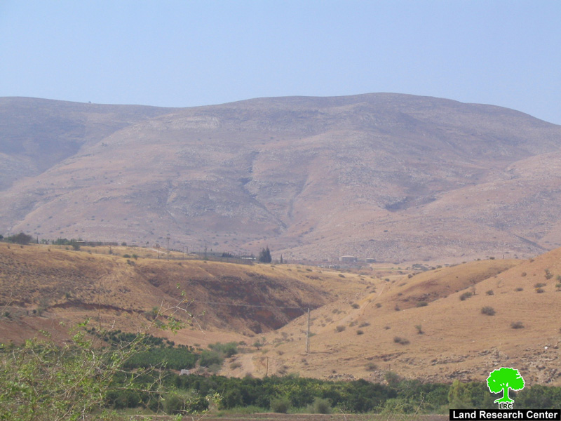
Photo 2: the western slopes of the Ghor region
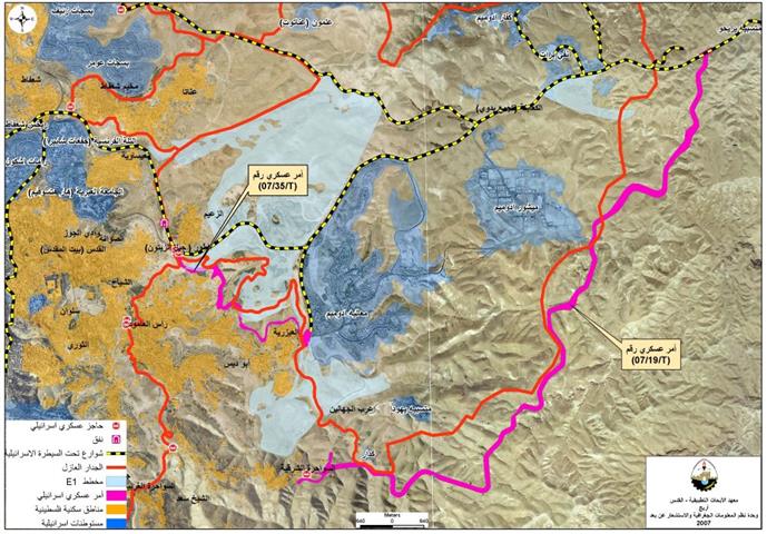
By the time the separation plan was completed Israel had already finished the setting up of six military checkpoints in the Ghor region, which are: Tayasir, Ma'ale Efrayim, ad Duyuk, DCO point, Hamra and Bardla ( Bisan). In addition, many sporadic checkpoints are setup between now and then all over the place to obstruct Palestinian movement in the area. In the meanwhile, the Israeli forces changed the checkpoints of Bardla ( Bisan), Tayasir and Hamra into border crossing points.
Most importantly, the Israeli government announced in the year 2005 the whole Ghor region as a non- negotiable issue meaning that it will remain under total Israeli control.
Map 2: The Ghor land area (in green color) after being
extended to three folds of its original area
The Segregation Wall
At the same level, the occupation authorities completed the building of the Segregation Wall along the northern Ghor borders starting from the village of Ein Al Baida in the east to the village of Mutalla in the west at the length of 15 km and width of 30 m. By so doing, the Wall has destroyed or separated more than 4000 dunums of agricultural land under or behind its path.
Water monopoly
Sine its occupation of the West Bank in 1967 the Israeli occupation authorities have continued to deprive Palestinians of their share in the waters of Jordan river estimated to be at 250 Million M3 annually. In the meantime, the drilling of underground water and the building of cisterns and wells has become a monopoly for the Israeli Mekharot company. In this regard, a number of wells have been dug up at different depths in various areas of the Ghor causing, either, the dryness of existing Palestinian water wells or raising the levels of their salinity. Consequently, Palestinians of the Ghor have no other option but to rely on buying water at high prices from the Israeli water carrier (Mekharot) for domestic or agricultural purposes.
Furthermore, the occupation authorities have destroyed more than 140 machines that were used for pumping of the underground water in the Ghor area.
Impacts of Israeli checkpoints on Palestinians
Three military checkpoints have already been changed into an international like – crossing points after equipping them with special car lanes, search rooms, metla detecting gates (magnetic gates), surveillance cameras, early warning systems and military watch towers.
Israeli soldiers manning these checkpoints continue to provoke and humiliate Palestinians as followed:
1. Keeping people waiting untended for long hours depending o the whims of individual Israeli soldiers;
2. Preventing people over the age of 30 from passing through checkpoints, especially on the occasions of Jewish national and religious holidays;
3. Making mockery of people and cursing them with bad language in violation of all human and international norms and ethics;
4. Preventing people from introducing in to the Ghor area food stuff, medicines, pesticides, insecticides solar panel systems under security pretexts;
5. Preventing Palestinian agricultural yields produced in the Ghor from entering Israel through the Bardala ( Bisan) border crossing under security claims.
6. Adding more obstacles on the process of transferring Palestinian agricultural goods from the Ghor area into the West Bank markets. This policy aims at killing the Palestinian agriculture, on one hand, and forcing people to continue to rely on imported Israeli products, on the other hand.
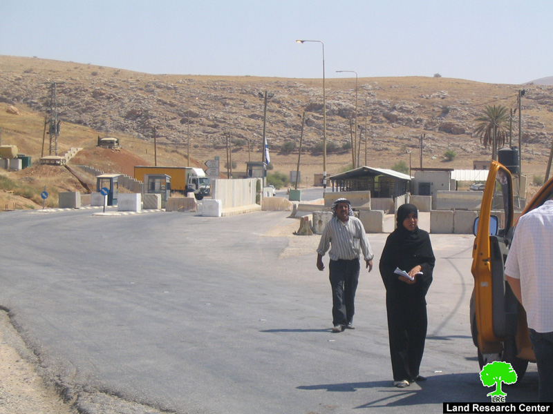
Photo 3: a Palestinian couple denied access to the Ghor area through the Hamra checkpoint
Prepared by
The Land Research Center
LRC