• About The Project
  • Palestine in Century
  • Selected Maps
  • Glossary
  • About ARIJ
  • About LRC
  • By Year
    • Case Studies By Year
    • Daily Report By Year
Sunday, October 12, 2025
POICA
No Result
View All Result
  • Home
  • Settlements
    • New Israeli Settlements
    • Settlement Expansion
  • Israeli Violations
    • Agriculture
    • Confiscation
    • Demolition
    • Environment
    • Eviction of Palestinians
    • Settlers Attacks
  • Bypass Roads
  • Israeli Plans
  • Segregation
    • Checkpoints
    • Closure
    • Separation Plans
  • Military Orders
  • Reports
    • Daily Report
    • Monthly Report
    • Quarterly Report
No Result
View All Result
POICA
No Result
View All Result

Israeli High Court allows the construction of the Segregation Wall on Lands of Um Salamuna village

September 5, 2007
in Segregation
Israeli High Court allows the construction of the Segregation Wall on Lands of Um Salamuna village

On August 2, 2007, the Israeli Supreme Court rejected the petition filed by the Palestinian residents of Um Salamouna village southwest Bethlehem Governorate, regarding the building of the Israeli Apartheid Wall which stretches across the village’s lands, isolating approximately 500 dunums which constitutes 41.5 % from the total village area (1200 dunums). The Israeli court rejected the petition filed by the local resident of the village using the common Israeli pretext 'vital to the security of Israel.'


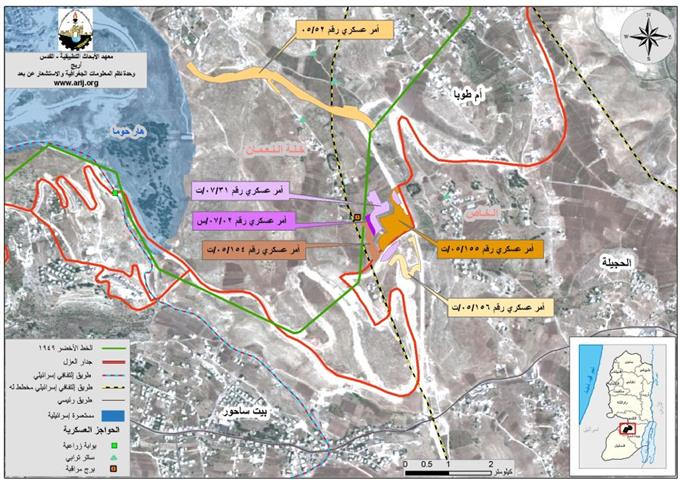
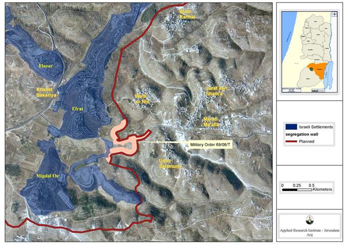
The Palestinian residents of Um Salamouna village filed the petition in January 25, 2007 to the Israeli Supreme Court under file number 07/834, after the Israeli Army started construction work to build the Israeli Apartheid Wall on their lands, causing severe damages to their agricultural areas. The filed petition specifically was put against the Israeli military order number 69/06/T, issued by the Israeli Army in September 5, 2006, in which 152 dunums of the village lands were declared confiscated to construct the planned Israeli terminal on the western entrance of Um Salamouna village and to resume the construction of the Israeli Apartheid Wall at the same area. See Map 1, issued by the Israeli Army in , in which of the village lands were declared confiscated to construct the planned Israeli terminal on the western entrance of Um Salamouna village and to resume the construction of the Israeli Apartheid Wall at the same area.

Map of Um Salamouna Village


Um Salamouna, Location & Population

Um Salamouna is a Palestinian village located 7.8 km south of Bethlehem Governorate. It has  a population of 807 residents (PCBS 2006). The village is bordered by Marah M’allah village and Za’tara bypass road from its north and the under construction  Israeli commercial terminal from its northwest, the Israeli Apartheid Segregation Wall from its western side, and to the eastern side is Al Halqum village, and Marah Rabah village at its south side.


The Israeli Tightening on Um Salamouna

Um Salamuna village became a target of the Israeli Army when it was decided to rip the village apart by building the Apartheid Wall and a terminal on the agricultural lands at the northwestern entrance of the village, cutting off the residents from their traditional link to surrounding areas for commercial or social activities.


 More over, The Israeli plan for Um Salamouna terminal comes to serve the Israeli policy to tighten the grip on the Palestinian residents and their movement and access to their agricultural lands, but more than that, it will serve as a commercial terminal leading to alternative route for the Palestinian trucks or any other form of Palestinian transportation on bypass road # 60, which will be restricted Israeli settlers use, another form of Israel’s apartheid system in the occupied Palestinian territory. For more clarification refer to the previously written case study (Israeli Military Orders to demolish Six Palestinian Houses in Um Salamouna Village South of Bethlehem City. May 8, 2007).


To Conclude

Um Salamouna village, as well as most of the Palestinian villages and cities, is facing an endless suffering because of the Israeli colonization practices against their lands and properties, and the Israeli Segregation Wall is one of the Israeli employed tools to loot and steal as much as possible of the Palestinian lands under the pretext of  'security.'


Under the International law rules and conventions, Israel is prohibited from destroying or/ and seizing Palestinians' lands and properties, unless such acts constitute a military necessary and as long it is carried out on temporary bases.                


  • Article 147 of the Fourth Geneva Convention indicated that: Extensive destruction and appropriation of property not justified by military necessity and carried out unlawfully and wantonly, is a grave breach of the Convention.

  • Article 23 of the Hague Convention of 1907 also provides: In addition to the prohibitions provided by special Conventions, it is especially forbidden to destroy or seize the enemy's property, unless such destruction or seizure be imperatively demanded by the necessities of war;


Prepared by
The Applied Research Institute – Jerusalem
ARIJ

Recommended For You

عقاب جماعي يومي: الفلسطينيون تحت هيمنة الحواجز العسكرية

by arij
September 24, 2025
0
عقاب جماعي يومي: الفلسطينيون تحت هيمنة الحواجز العسكرية

تشهد الضفة الغربية المحتلة واقعًا خانقًا نتيجة السياسات الإسرائيلية المتمثلة بفرض المزيد من الحواجز العسكرية اليومية والإغلاقات، والتي باتت أداة منهجية للسيطرة والتحكم بحياة الفلسطينيين اليومية، وليست مجرد...

Read moreDetails

العدالة المؤجلة ورأي بلا تنفيذ: من قرار المحكمة إلى واقع الضم

by arij
July 9, 2025
0
العدالة المؤجلة ورأي بلا تنفيذ: من قرار المحكمة إلى واقع الضم

مقدمة في التاسع من تموز 2004، أصدرت محكمة العدل الدولية، وهي الجهاز القضائي الرئيسي للأمم المتحدة، رأيا استشاريا تاريخيا اعتبرت فيه بناء اسرائيل لجدار الفصل في الاراضي الفلسطينية...

Read moreDetails

سلطات الاحتلال الإسرائيلي تفرض واقعا جيوسياسيا جديدا في منطقة شمال قطاع غزة المحتل

by arij
March 13, 2024
0
سلطات الاحتلال الإسرائيلي تفرض واقعا جيوسياسيا جديدا في منطقة شمال قطاع غزة المحتل

  أظهرت صور الأقمار الصناعية الصادرة عن برنامج مراقبة الأرض التابع للاتحاد الأوروبي (كوبرنيكوس) لقطاع غزة المحتل في العاشر من شهر اذار من العام 2024، ان سلطات الاحتلال...

Read moreDetails

الحرب على قطاع غزة وتأثيرها على محافظة الخليل جنوب الضفة الغربية

by arij
November 30, 2023
0

  تقع محافظة الخليل في الجزء الجنوبي من الضفة الغربية المحتلة، إلى الجنوب من مدينة القدس، وعلى بعد حوالي 36 كم منها. يحدها من الشمال محافظة بيت لحم،...

Read moreDetails

تطبيق سياسة الفصل العنصري على استخدام الطرق الرئيسية في الضفة الغربية وتقيد حركة وتنقل المواطنين الفلسطينيين

by arij
November 22, 2023
0
معاناة شجرة الزيتون الفلسطينية بسبب الاحتلال والاستيطان في العام 2023

  بناء على تقديرات مراقبين دوليين يبلغ عدد الحواجز الإسرائيلية في الضفة الغربية أكثر من 567 حاجز إسرائيلي متعددة الاشكال منها 77 حاجزًا رئيسيًا وجزئي تتحكم في حركة...

Read moreDetails
Next Post
الاحتلال الاسرائيلي يصادر أراض جديدة من قرية النعمان شرقي بيت ساحور

الاحتلال الاسرائيلي يصادر أراض جديدة من قرية النعمان شرقي بيت ساحور

LATEST NEWS

محافظة أريحا على خريطة المصادرة الإسرائيلية- إسرائيل تسعى للاستحواذ على أكثر من 7000 دونم في منطقة النبي موسى

محافظة أريحا على خريطة المصادرة الإسرائيلية- إسرائيل تسعى للاستحواذ على أكثر من 7000 دونم في منطقة النبي موسى

by arij
October 9, 2025
0

........................................................

ما يزيد عن 1900 دونما من الأراضي الفلسطينية في بيت لحم مهددة بالعزل لصالح مستوطنة افراتا

ما يزيد عن 1900 دونما من الأراضي الفلسطينية في بيت لحم مهددة بالعزل لصالح مستوطنة افراتا

by arij
October 8, 2025
0

........................................................

Annexation of the Jordan Valley: Implications for the Two-State Solution and Regional Stability

Annexation of the Jordan Valley: Implications for the Two-State Solution and Regional Stability

by arij
September 29, 2025
0

........................................................

Isolation of Three Villages Northwest of Jerusalem: Silent Annexation Creeps toward the Capital

عزل ثلاث قرى فلسطينية شمال غرب مدينة القدس: الضم الاسرائيلي الصامت يزحف نحو محيط العاصمة

by arij
September 24, 2025
0

........................................................

flag_yellow_lowEU-PfP-Logo

This website and its content were initiated in 1993 by the Applied Research Institute – Jerusalem (ARIJ) and the Land Research Center (LRC) with the support from the European Union up until 2023. Since then, the Applied Research Institute – Jerusalem (ARIJ) has taken over the continued development and maintenance of the website. The views expressed remain solely those of ARIJ) and do not necessarily reflect those of the European Union.

© 2025 Copyright ARIJ . All Rights reserved. .

No Result
View All Result
  • Home
  • Settlements
    • New Israeli Settlements
    • Settlement Expansion
  • Israeli Violations
    • Agriculture
    • Confiscation
    • Demolition
    • Environment
    • Eviction of Palestinians
    • Settlers Attacks
  • Bypass Roads
  • Israeli Plans
  • Segregation
    • Checkpoints
    • Closure
    • Separation Plans
  • Military Orders
  • Reports
    • Daily Report
    • Monthly Report
    • Quarterly Report

© 2025 Copyright ARIJ . All Rights reserved. .