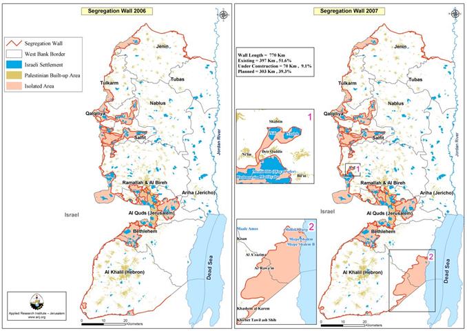
After one and a half year of releasing the updated version of the revised Segregation Wall map in the West Bank, the Israeli Ministry of Defense has published a new revised route of the Segregation Wall map that shows changes of large magnitude in the Segregation Wall's length and land areas isolated to what was than in April 2006. The new map that was published on the IDF's website in September 2007 was actually sanctioned back to April 2007, but was only published on the website until now.
The new map revealed an increase of 28.5% (157.920 thousands Dunums) in the area to be isolated between the Segregation Wall and the 1949 Armistice Line in comparison to 555 km² in 2006, where the total isolated area became 712,9 km² (712.9 thousands Dunums). In addition, the new route of the Segregation Wall showed an increase in the Segregation Wall's length by 9.5% (67 Km) to the 703 Km recorded in April 30, 2006, by which the new length of the Segregation Wall became 770 Km.
The changes accrued in the length of the Segregation Wall and the area increased behind it where distinct in two specific areas, the first of which is at the southeast terrains south of the Jordan Valley area along the nature reserve areas east of Bethlehem and Hebron Districts. The new addition to the router of the Wall starts off the southern part of Hebron Governorate and continues towards the northeastern; an increase in the wall's section length in that area of 53.5 km, which in turn caused the isolation of an additional area of 153.780 thousand Dunums.
An additional consequence that occurred as a result to the new section added to the Segregation Wall length there is the fact that Israel stand to deprive the Palestinians of 71 Km² (37%) of the 194-km² area designated to them in the Dead Sea area.
The second change in the Segregation Wall route took place northwest of Ramallah city. It showed an increase in the Wall length by 13.5 km and an area isolated of 4140 Dunums. The new alteration there aimed to include the Israeli settlements of Nili and Na'ale. See Table one for more Details
|
Table 1: Status of the Segregation Wall as of April 2007 |
||
|
Wall Status |
Wall Length |
Percent of the Total wall Length |
|
Existing Wall |
397 |
51.6 |
|
Under Construction Wall |
70 |
9.1 |
|
Planned Wall |
303 |
39.3 |
|
|
|
|
|
Total |
770 |
100 |
Source: ARIJ GIS Database 2007
To Conclude
This is not the first time that the Israeli ministry of defense makes changes with regard to the Segregation Wall's route in the West Bank; in fact, this is the fourth alteration to the Segregation Wall since the Israeli Government sanctioned its construction in the West Bank. Each change in Wall route showed an increase in wall's length and the segregated area. At no time has any of these changes made considered the Palestinian populace interest; despite the hundreds of petitions filed by Palestinians to the Israeli Supreme court to protest the dramatic losses that came along with the construction of the Wall. See Table 2 for more details.
|
Table 2: Changes on the Segregation Wall Route between June 2004 and April 2007 |
|||
|
Date of Change |
Wall Length |
Area Isolated |
% of the West Bank Area |
|
June 2004 |
645 |
633 km² |
11.2 |
|
February 2005 |
683 |
565 km² |
10 |
|
April 2006 |
725 |
555 km² |
9.8 |
|
April 2007 |
770 |
713 km² |
12.6 |
Source: ARIJ GIS Database 2007
The Israeli Government continues to ignore the rights of Palestinians and violate the international law as it realizes all what it do goes with impunity. Israel continues to disregard the International Court of Justice ruling of July 9, 2004 despite all criticism. Apparently, Israel will continue to inflect changes on the ground to manipulate the outcome of any possible future negotiation over land, borders, and Jerusalem. Israel quest to grab Palestinian lands has been insist in pace, which is why, it is this time that the international community must step in and put an end to Israel’s egotistical acts so the peace process might go back on track again.
Prepared by
The Applied Research Institute – Jerusalem (ARIJ)


