• About The Project
  • Palestine in Century
  • Selected Maps
  • Glossary
  • About ARIJ
  • About LRC
  • By Year
    • Case Studies By Year
    • Daily Report By Year
Monday, June 30, 2025
POICA
No Result
View All Result
  • Home
  • Settlements
    • New Israeli Settlements
    • Settlement Expansion
  • Israeli Violations
    • Agriculture
    • Confiscation
    • Demolition
    • Environment
    • Eviction of Palestinians
    • Settlers Attacks
  • Bypass Roads
  • Israeli Plans
  • Segregation
    • Checkpoints
    • Closure
    • Separation Plans
  • Military Orders
  • Reports
    • Daily Report
    • Monthly Report
    • Quarterly Report
No Result
View All Result
POICA
No Result
View All Result

Uprooting of Trees in the Vicinity of Rachel’s Tomb

June 10, 2007
in Israeli Violations
Uprooting of Trees in the Vicinity of Rachel’s Tomb

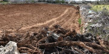
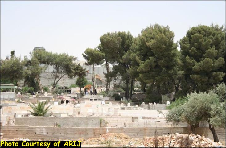
On June 6, 2007, the Israeli Army established a security perimeter around the Islamic cemetery adjacent to the Rachel Tomb area, and declared it a closed military area. The Islamic Cemetery falls under the jurisdiction of the Islamic Waqf, which is responsible for all Islamic religious sites. The Israeli Army started without prior notification an operation that lasted three days to uproot the Pine trees inside the cemetery in order to establish a buffer zone between the cemetery and the adjacent Israeli Apartheid Segregation Wall in the area. More than that, the Army aims to eliminate any link between the Islamic Cemetery and the Tomb area. See Photos below


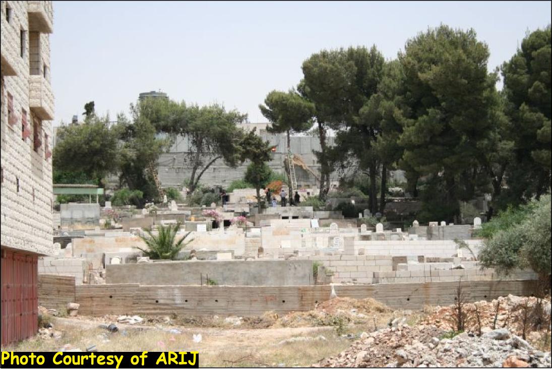
Pictures of the Uprooting in the Cemetery


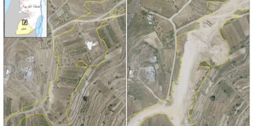
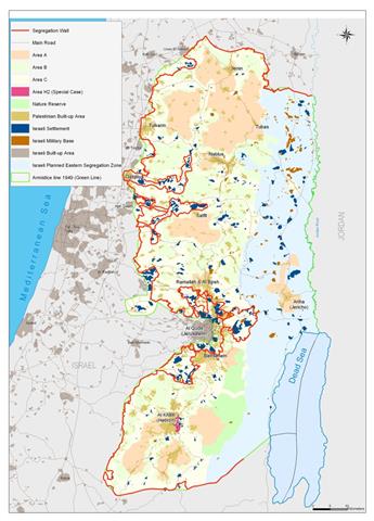
It is worth mentioning that this is not the first timethe Israeli occupation perpetrated desecration against the sanctity of the Muslim cemetery. On July 19, 1999 a Jewish contractors protected by the Israeli Army demolished the northern part of the Islamic Cemetery near Rachel's to reinforce the Israeli military installation in the area. See Map 1


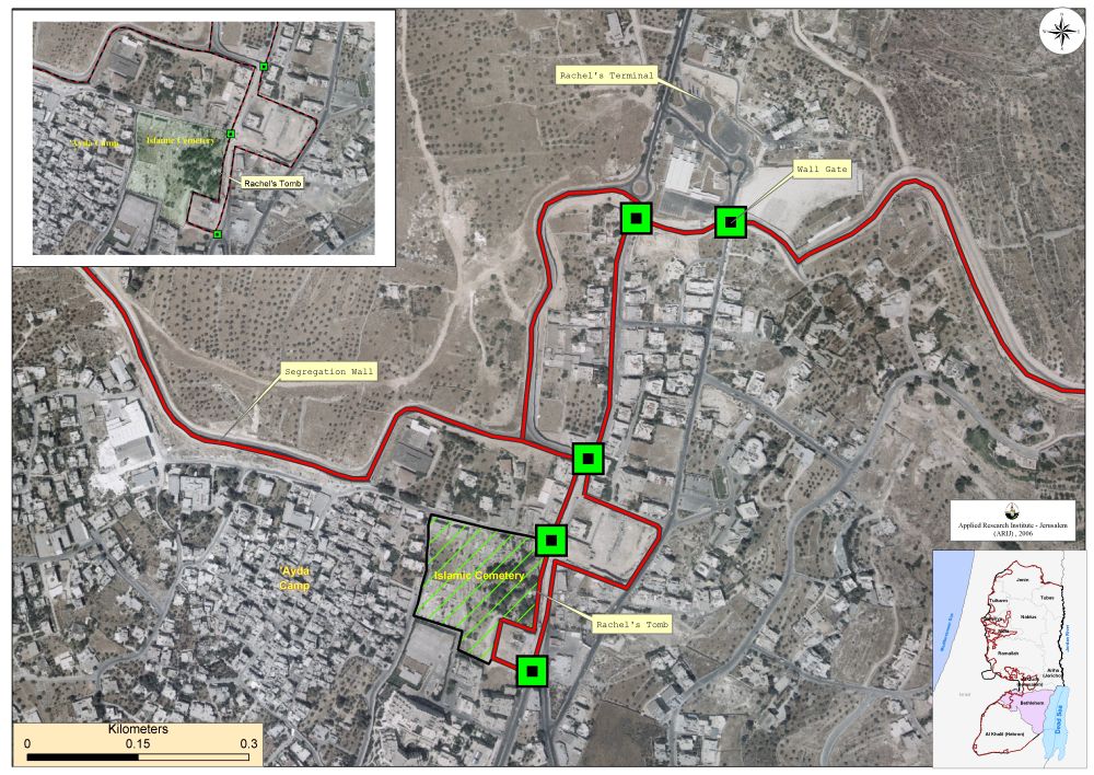
Map of the Rachel Tomb Area

The Status of Rachel Tomb Area

In September 2002, the Israeli government approved to keep Rachel's Tomb under the Israeli control by including the Tomb within the Apartheid Segregation Wall. However, the Islamic Cemetery area, which is traditionally correlated with the Tomb area, was kept out of the Segregation Wall.


The location of the Tomb area became a major and controversial issue for Bethlehem city and Governorate as a whole. The Israeli Army cutoff the traditional link between Bethlehem and Jerusalem, when the road linking the two cities was closed in a permanent manner in 2002 with concrete blocks under the pretext of protecting the Tomb area. The Tomb area was also used by the Israeli Army as a pretext to establish the security perimeter around the vicinity of the Tomb where Palestinian houses became isolated and restricted in movement of their residents to other places. Moreover and more significantly, the Tomb area was the reason under which the Israeli Army set the route of the Segregation Wall at the northern entrance of Bethlehem as it is today, and where residents of Bethlehem lost accordingly more than 3000 Dunums of empty lands set for expansion of the already limited built-up area of the city.


To Conclude

The Israeli Army insist on violating the International law rules, even more it insist that it wants to isolate all the Palestinians, even the dead ones. The Israeli Army has proven repeatedly that it will commit any sacrilege under the security pretext; this time by uprooting trees in a holy site to establish a security buffer zone even if it meant violating all humanitarian law.


Prepared by
The Applied Research Institute – Jerusalem
ARIJ

Recommended For You

At the Southeast Bethlehem Governorate: Al-Minya and Kisan Villages Caught Between Forced Displacement and Israel’s Expanding Settlement Plans

by arij
June 21, 2025
0
At the Southeast Bethlehem Governorate: Al-Minya and Kisan Villages Caught Between Forced Displacement and Israel’s Expanding Settlement Plans

General Context: Overview The villages of Al-Minya and Kisan, located within an area called by the Gush Etzion settlement Council (Gush Etzion-east) in the southeastern part of Bethlehem...

Read moreDetails

جنوب شرق بيت لحم: قرى المنيا وكيسان بين مطرقة التهجير وسندان مخطط التوسع الاستيطاني الإسرائيلي

by arij
June 21, 2025
0
جنوب شرق بيت لحم: قرى المنيا وكيسان بين مطرقة التهجير وسندان مخطط التوسع الاستيطاني الإسرائيلي

 في السياق العام: الخلفية الجغرافية والاستراتيجية تقع قريتا المنيا وكيسان في جنوب-شرق محافظة بيت لحم جنوب الضفة الغربية، وتتميزان بموقع استراتيجي فاصل بين التجمع الاستيطاني الإسرائيلي “غوش عتصيون”...

Read moreDetails

ثمانية وخمسون عاما على حرب 1967: تقويض حل الدولتين

by arij
June 5, 2025
0
ثمانية وخمسون عاما على حرب 1967: تقويض حل الدولتين

عندما دخلت منظمة التحرير الفلسطينية (م. ت. ف.) في عملية السلام مع إسرائيل من خلال توقيع اتفاقية أوسلو بتاريخ 13 أيلول 1993، فعلت ذلك على أمل — شاركها...

Read moreDetails

58 Years since the 1967 War: Undermining the Two-State Solution

by arij
June 5, 2025
0
58 Years since the 1967 War: Undermining the Two-State Solution

When the Palestine Liberation Organization (PLO) entered into the peace process with Israel through the signing of the Oslo Accord on September 13, 1993, it did so with...

Read moreDetails

77 عام  على النكبة الفلسطينية: حاضر مستمر لا تاريخ منتهي

by arij
June 23, 2025
0
77 عام  على النكبة الفلسطينية: حاضر مستمر لا تاريخ منتهي

  في الذكرى السابعة والسبعين للنكبة، لا نستحضر مجرد صفحة دامية من ماضٍ بعيد، بل نفتح كتابًا لا يزال يُكتب بمداد الدم والذاكرة. فليست النكبة واقعةً انقضت، بل...

Read moreDetails
Next Post
The Israeli Colonization activities in the Occupied Palestinian Territory during the Second Quarter of 2007

The Israeli Colonization activities in the Occupied Palestinian Territory during the Second Quarter of 2007

LATEST NEWS

أمر عسكري إسرائيلي يستهدف أراضي قرية زبوبا الفلسطينية لأغراض أمنية مستعجلة

Israeli Order Targets Zububa Village Under Security Claims

by arij
June 24, 2025
0

........................................................

أمر عسكري إسرائيلي يستهدف أراضي قرية زبوبا الفلسطينية لأغراض أمنية مستعجلة

أمر عسكري إسرائيلي يستهدف أراضي قرية زبوبا الفلسطينية لأغراض أمنية مستعجلة

by arij
June 21, 2025
0

........................................................

At the Southeast Bethlehem Governorate: Al-Minya and Kisan Villages Caught Between Forced Displacement and Israel’s Expanding Settlement Plans

At the Southeast Bethlehem Governorate: Al-Minya and Kisan Villages Caught Between Forced Displacement and Israel’s Expanding Settlement Plans

by arij
June 21, 2025
0

........................................................

جنوب شرق بيت لحم: قرى المنيا وكيسان بين مطرقة التهجير وسندان مخطط التوسع الاستيطاني الإسرائيلي

جنوب شرق بيت لحم: قرى المنيا وكيسان بين مطرقة التهجير وسندان مخطط التوسع الاستيطاني الإسرائيلي

by arij
June 21, 2025
0

........................................................

flag_yellow_lowEU-PfP-Logo

This website has been produced with the assistance of the European Union. The contents of this publication are the sole responsibility of ARIJ & LRC and can in no way be taken to reflect the views of the European Union.

© 2025 Copyright ARIJ . All Rights reserved. .

No Result
View All Result
  • Home
  • Settlements
    • New Israeli Settlements
    • Settlement Expansion
  • Israeli Violations
    • Agriculture
    • Confiscation
    • Demolition
    • Environment
    • Eviction of Palestinians
    • Settlers Attacks
  • Bypass Roads
  • Israeli Plans
  • Segregation
    • Checkpoints
    • Closure
    • Separation Plans
  • Military Orders
  • Reports
    • Daily Report
    • Monthly Report
    • Quarterly Report

© 2025 Copyright ARIJ . All Rights reserved. .