• About The Project
  • Palestine in Century
  • Selected Maps
  • Glossary
  • About ARIJ
  • About LRC
  • By Year
    • Case Studies By Year
    • Daily Report By Year
Friday, May 9, 2025
POICA
No Result
View All Result
  • Home
  • Settlements
    • New Israeli Settlements
    • Settlement Expansion
  • Israeli Violations
    • Agriculture
    • Confiscation
    • Demolition
    • Environment
    • Eviction of Palestinians
    • Settlers Attacks
  • Bypass Roads
  • Israeli Plans
  • Segregation
    • Checkpoints
    • Closure
    • Separation Plans
  • Military Orders
  • Reports
    • Daily Report
    • Monthly Report
    • Quarterly Report
No Result
View All Result
POICA
No Result
View All Result

New Israeli parallel road in Yatta area

December 9, 2006
in Bypass Roads
New Israeli parallel road in Yatta area

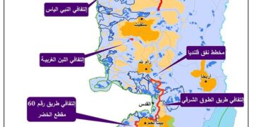
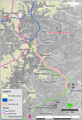
The Israeli supreme committee for planning and the sub-committee for roads affiliated to the so-called Israeli 'civil administration in Judea and Samaria' announced a new scheme for the bypass road number 356 passing by the villages of Zif, Al Buweib and ad Dirat located east of Yata town, Hebron governorate. 


According to the attached map which was distributed by the Israeli authorities along with the announcement, the new proposed section of the road is about 7600 meters long by 160 meters wide. This means that a total of 1216 dunums will be confiscated for the path of the road. In addition, thousands of other dunums will be separated behind the eastern bank of the road once it has been established and protected by special security arrangements which include road barriers, fencing and buffer zones.


(Map 1:  The parallel road route number 356)


The target land is located in the Masafer area which is part of the eastern slopes of Herbron governorate.  The following table provides data about the affected villages which are located along the route of the proposed road scheme threatening to confiscate and/or separate parts of their lands:   


No.

Village name

Population

1

Zif

750

2

Hureiz

800

3

Biar Al Arus

750

4

Ad Duweir

600

5

Al Buweib

500

6

Qurnat ar Ras

250

7

Ar Rifa'iyya

300

8

Khallet Al Maiyya

1000

9

Ad Dirat

350

10

Umm Lasafa

500

11

Az Zuweiden

550


Total

6350


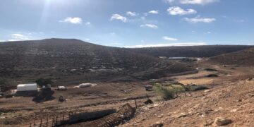
Most of the target lands are used for cereal and straw production as well as range land for local cattle.


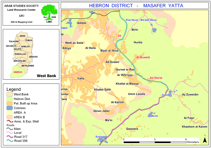
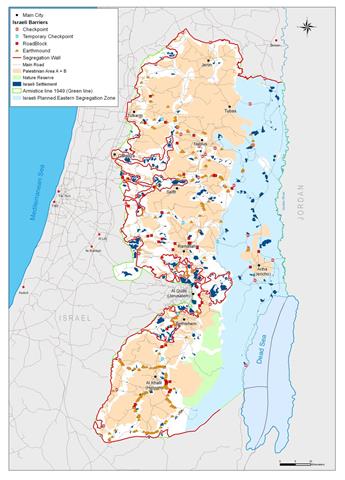
 map 2: Masafer Yatta, eastern slopes of Hebron governorate

For exclusive Jewish use

The planned road will be utilized for exclusive Jewish use so as to link the following five colonies with Hebron and Jerusalem, on one hand, and to link them with the Bir Sheva and Arad cities, on the other hand:  


Colony name

Date of establishment

Population in 2003

Karmel

1981

321

Ma'on

1981

327

Susiya

1983

643

Mezadot Yehuda ( Beit Yattir) 

1980

412

Shani

1989

438

Total


2141


Disastrous impact

The planned road route will have the following impacts on Palestinians:

1.     Blocking the villages' natural expansion east forward and confining their limits to  current land areas;

2.     Rendering vast areas of range and agricultural lands inaccessible to local citizens  who mostly depend on animal husbandry as main income;

3.     Stopping the territorial continuity between Yatta town to the west of the proposed road route and its periphery villages to the east of the route.  


Village planning schemes

The new road announcement coincided with the Israeli announcement of three detailed planning schemes for the villages of Zif, Al Buweib and Ad Dirat. In an interview with layer Musa Makhamrah, the head of the Land Defense Committees, he confirmed to LRC field worker that the Israeli published schemes do not fulfill the present and future needs of the target villages in terms of natural demographic growth and expansion. On the contrary, these schemes will cripple any expansions in the existing built up areas and confine their residents to certain areas after besieging them with Israeli settlements and bypass roads.


Legal action

The Israeli announcements gave a two month ultimatum for 'legal' objection starting from the date of publishing  in the local newspaper. In this regards,  affected land owners and village councils are preparing all the related land ownership documents and papers to present to the Israeli civil administration's legal advisor at Beit Eil. Not much hope is expected by the affected persons as previous experiences proved useless.


House demolition campaign

The latest Israeli road and planning scheme announcements came at a time when the Israeli occupation authorities are carrying a demolition campaign against Palestinian houses, farms, cisterns and animal sheds and barrack in the aforementioned villages under the pretext of un-licensing. More than ten premises have been demolished so far within the past few weeks.


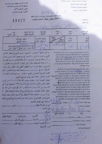
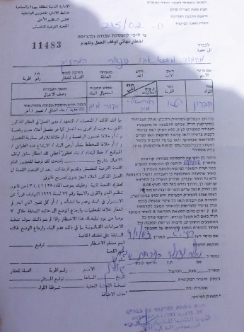
 Photos 1 & 2: copies of house demolition orders in Umm Lasafa village, Yatta)


Prepared by
The Land Research Center
LRC

Recommended For You

شق طريق استيطاني جديد يهدد سبل العيش في قرية بردلة

by arij
January 13, 2025
0
New Israeli Settlement Road Construction and Its Impact on the Village of Bardala in the Jordan Valley

المكان: تجمع بردلة- محافظة طوباس/الأغوار الزمان: سبتمبر 2024 الجهة المتضررة: أهالي قرية بردلة والقرى المجاورة الجهة المعتدية: ما تسمى بالإدارة المدنية الاسرائيلية الانتهاك: شق طريق استيطاني تفاصيل الانتهاك:...

Read moreDetails

New Israeli Settlement Road Construction and Its Impact on the Village of Bardala in the Jordan Valley

by arij
December 31, 2024
0
New Israeli Settlement Road Construction and Its Impact on the Village of Bardala in the Jordan Valley

  The construction of new settlement infrastructure in the occupied Palestinian territories has profound implications for local communities, threatening livelihoods, increasing isolation, and impairing socio-economic vulnerabilities. This case...

Read moreDetails

الطرق الالتفافية الاسرائيلية وأثرها على البيئة الفلسطينية

by arij
January 16, 2024
0
الطرق الالتفافية الاسرائيلية وأثرها على البيئة الفلسطينية

  الاعتداءات الإسرائيلية على الفلسطينيين لا تقتصر على التنكيل بالافراد، أو وضع القيود على الحركة والتنقل، أو استهداف المنازل والمنشات، أو مصادرة الأراضي، أو نهب الموارد والمصادر الطبيعية،...

Read moreDetails

Israeli Colonists Take Over an Agricultural Road in Ya’bad town / Jenin Governorate

by arij
January 12, 2022
0
Israeli Colonists Take Over an Agricultural Road in Ya’bad town / Jenin Governorate

  Violation: Taking over an agricultural road for the favor of colonization. Location: Ya’bad town / Jenin Governorate. Date: October 17th 2021. Perpetrators: Mevo Dotan Colony. Victims: Farmers...

Read moreDetails

New Colonial road to Be Opened on Sarta Village lands / Salfit Governorate

by arij
July 17, 2021
0
New Colonial road to Be Opened on Sarta Village lands / Salfit Governorate

  Violation: Opening a new Colonial Roads. Location: Sarta village/ Salfit Governorate. Date: June 1st 2021. Perpetrators: The Israeli Illegal Industrial Colony (Barkan). Victims: Farmers from the village....

Read moreDetails
Next Post
معهد الأبحاث التطبيقية – القدس (أريج) يوجه نداء استغاثة لرفض الصيغة الحالية لاقتراح الجمعية العمومية للأمم المتحدة بتسجيل الخسائر الناجمة عن بناء جدار الفاصل العنصري

معهد الأبحاث التطبيقية – القدس (أريج) يوجه نداء استغاثة لرفض الصيغة الحالية لاقتراح الجمعية العمومية للأمم المتحدة بتسجيل الخسائر الناجمة عن بناء جدار الفاصل العنصري

LATEST NEWS

الأراضي الفلسطينية بين الذرائع الأمنية والأطماع الاستيطانية – “الأمن، الآثار، والطبيعة كحجج لاقتلاع الفلسطينيين من أراضيهم”

by arij
April 15, 2025
0

........................................................

الطرق الالتفافية الاسرائيلية وأثرها على البيئة الفلسطينية

انتهاك للطبيعة والهوية في الأراضي الفلسطينية المحتلة

by arij
March 17, 2025
0

........................................................

Israel Advances Settlement Plan on Ancient Olive Groves on lands of Beit Jala city, Violating International Law and depriving Palestinians their lands

إسرائيل تمضي قدمًا في مخطط استيطاني جديد على أراضي مدينة بيت جالا، في انتهاك للقانون الدولي وحرمان الفلسطينيين من أراضيهم

by arij
April 29, 2025
0

........................................................

Israel Advances Settlement Plan on Ancient Olive Groves on lands of Beit Jala city, Violating International Law and depriving Palestinians their lands

Israel Advances Settlement Plan on Ancient Olive Groves on lands of Beit Jala city, Violating International Law and depriving Palestinians their lands

by arij
April 29, 2025
0

........................................................

flag_yellow_lowEU-PfP-Logo

This website has been produced with the assistance of the European Union. The contents of this publication are the sole responsibility of ARIJ & LRC and can in no way be taken to reflect the views of the European Union.

© 2025 Copyright ARIJ . All Rights reserved. .

No Result
View All Result
  • Home
  • Settlements
    • New Israeli Settlements
    • Settlement Expansion
  • Israeli Violations
    • Agriculture
    • Confiscation
    • Demolition
    • Environment
    • Eviction of Palestinians
    • Settlers Attacks
  • Bypass Roads
  • Israeli Plans
  • Segregation
    • Checkpoints
    • Closure
    • Separation Plans
  • Military Orders
  • Reports
    • Daily Report
    • Monthly Report
    • Quarterly Report

© 2025 Copyright ARIJ . All Rights reserved. .