
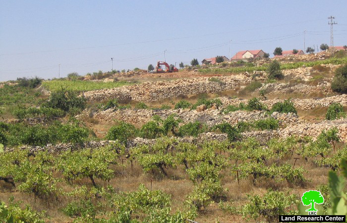
(Photo 1: Israeli bulldozers work in Palestinian land near Karmei Zur settlement)
On Thursday August 24th, 2006, Israeli bulldozers resumed works in the construction of the Segregation Wall around the settlement of Karmei Zur between the towns of Beit Ummer and Halhul, Hebron governorate.
Farmers and land owners from Halhul said to LRC field worker that Israeli Wall contractors started at an early hours of Thursday to bulldoze large areas of their lands in the south eastern side of the settlement in preparation for the erection of the Wall. These works were carried out under heavy army presence.

(Photo 2: land devastation across Palestinian fields)
The head of Halhul Municipality, Mr. Ziyad Abu Yusif, confirmed that the resumption of the Wall works around Karmei Zur aims at creating new realities on the ground before a final decision has been taken by the Supreme Israeli court on September 7th, 2006. He added that the latest Israeli action is a clear violation of the Supreme Court's decision which calls for the stoppage of all Wall works around the settlement until such final resolution is taken. Three months ago, Mr. Abu Yusif added the municipalities of Halhul and Beit Ummer, on behalf of land owners and farmers, appealed to the Supreme Court against the Israeli decision to construct a Wall at the expense of their land.
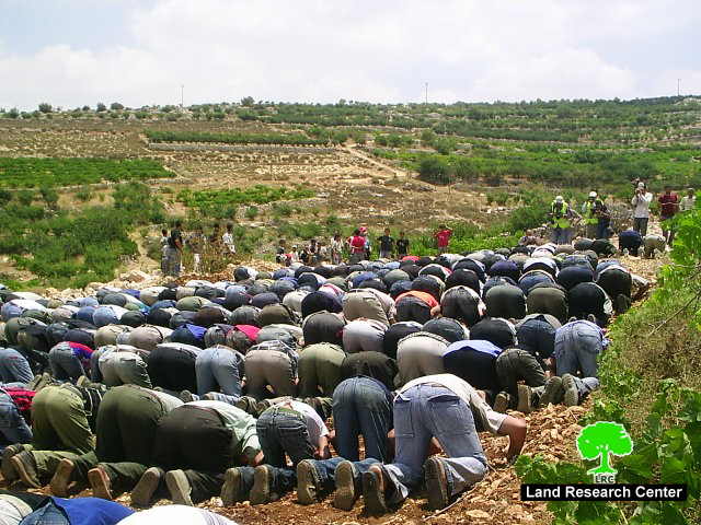
(Photo 3: Palestinians from Beit Ummer and Halhul pray on their threatened land near karmei Zur)
In April, 2005, the Israeli military issued order number T/69/05 stating the confiscation of 45.5 dunums (a strip of land at the length of 3241 meter and maximum width of 26 meters) from Beit Ummer and Halhul towns for the construction of the Wall. (For further information, please see case study ' Expansion of Karmei Zur settlement at the expense of Beit Ummer and Halhul lands' April,2005).
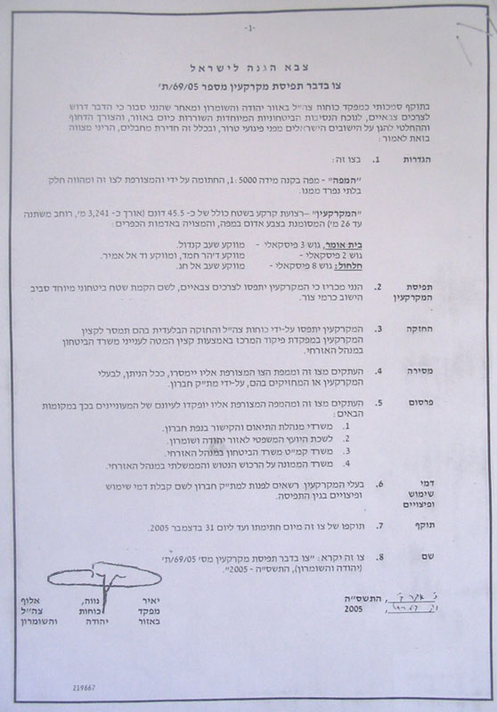
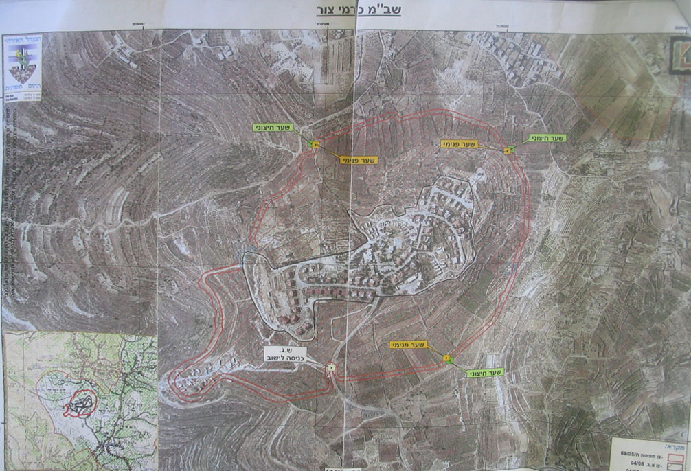
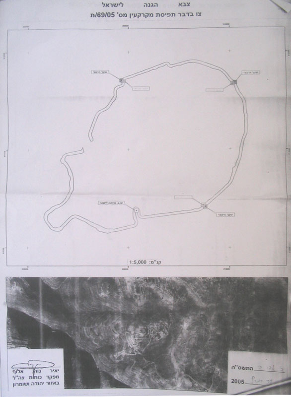
Photo 4, 5 & 6: Copies of military order No. T/69/05 and the attached maps)
The above number doesn't include the area that will be separated between the already existed fence and the new proposed Wall. This area is estimated at 400 dunums of fertile agricultural land planted with olive, grape, peach and almond trees (source: Beit Ummer municipality).
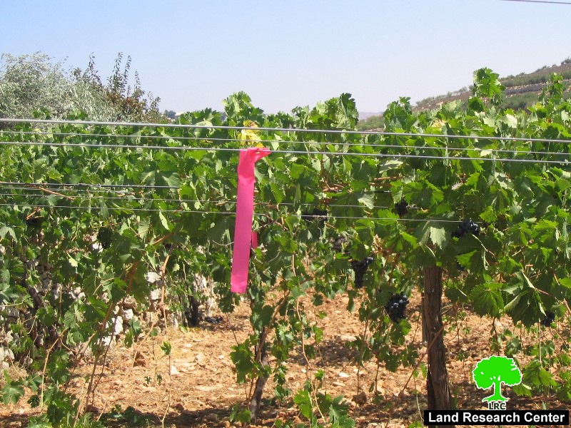
(Photo 7: grape trees on which red ribbons were fixed by the Israeli
army as a sign of possible uprooting)
Earlier this year, more than 200 dunums of Beit Ummer's agricultural lands have been devastated or separated from their owners as part of the Wall construction process out side the northern borders of the settlement ( between Beit Ummer and Karmei Zur). The latest Wall works in Halhul lands came as a continuation of this process.
Once the Wall around karmei Zur has been completed the Beit Ummer town will be strangled between the jaws of Karmei Zur's Wall in the south and Gush Etzion's planned Wall in the north, a process that will lead to the devastation, confiscation and separation of at least 4500 dunums of fertile agricultural land in the north and south of the town which, nowadays, occupies the lead in agricultural products in Hebron district. See Map 1

Karmei Zur settlement
It was established in 1984 over land taken from Beit Ummer and Halhul towns. It is affiliated to Etzion Block settlements. In the year 2004, it had the population of 664 settlers. It's built up area is 160 dunums and municipal area is 226 dunums (source: Foundation for Middle East Peace).
On the eve of Sharon's winning of the general elections in the year 2001 a new colonial post was erected outside the settlement's south western borders. Currently, it contains about 25 caravans (mobile homes) as appeared in the attached aerial photo. This colonial post was established on Halhul land.

(Photo 8: in the forefront is the new expansion of karmei Zur, in the middle
is Karmei Zur itself, in the back front is Beit Ummer town)
The land targeted for Wall construction is owned by the families of Abu Dayyeh, Abu Yusif, 'Aqil, Barbarawi and Midhia from Halhul, as well as the families of Abu 'Ayash, Bregheith, Abu Marya, Awad and Bu'ran from Beit Ummer. It is located in the following area:
-
Beit Ummer: Shi'ib Qandul, basin number 3; Daher Hamad, Wadi Al Amir, basin number 2.
-
Halhul: Shi'ib Al Haj, basin number 8.
Tree uprooting
During the bulldozing process that was carried out last Thursday and Friday, 22 olive trees and 50 almond trees were uprooted from the target land. Another 28 olive trees were separated behind the path of the Wall.
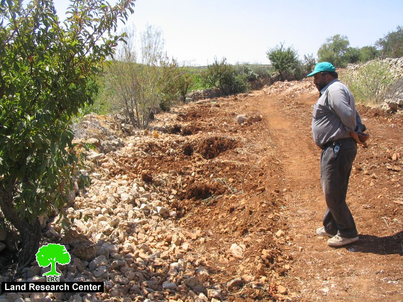
(Photo 9: A Palestinian farmer from Halhul looking at a row of earth
holes caused by uprooting his olive trees to make room for the Wall construction)
Gradual land grabbing
On March 31st, 2005, just one week before the handing over of the above-mentioned order, another two military orders were issued regarding the same lands:
-
The first one carries the number of S/04/05 (378), 5730-1970, announcing the closure of the land surrounding the settlement 'for military and security purposes' (The striped part appeared on the attached map is the closed land, the white part is the current settlement built up area).
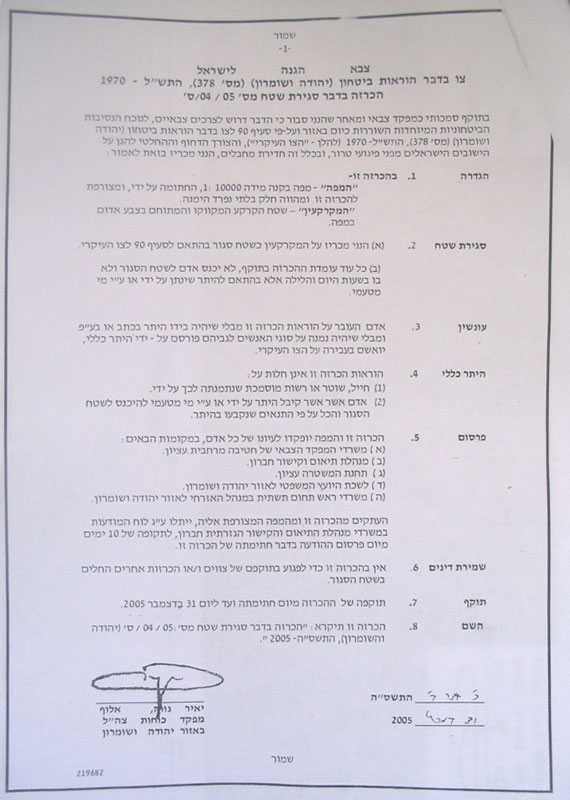
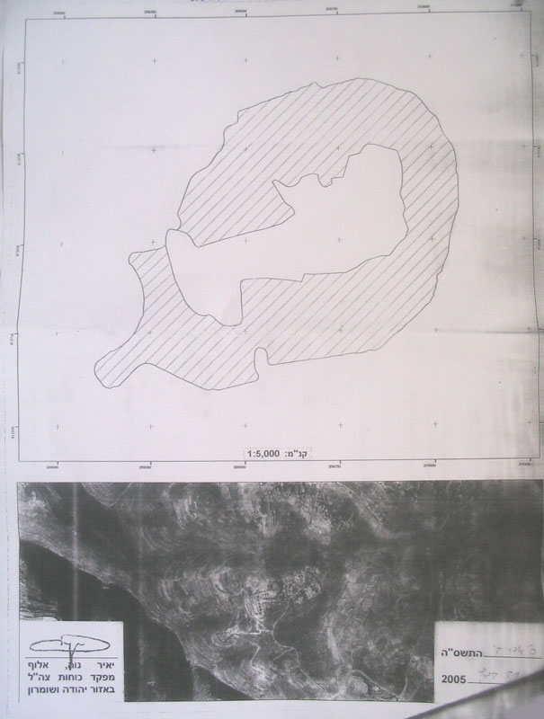
Photos 10 & 11: copy of military closure order No. S/04/05 (378 and attached map)
The order says that no one should enter the land without acquiring permission from the Israeli military.
-
The second one carries the number of 04/05 (393), 5730 -1970, 5763 -2003 prohibiting Palestinian building in the target land for 'military and security purposes'. (The striped part appeared on the attached map is the no – building area, the white part is the current settlement built up area).

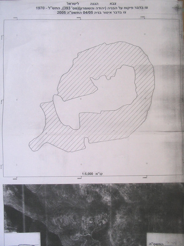
Photos 12 & 13: copy of military closure order No. 04/05 ( 393 and attached map)
Recent objections:
A series of Objections were presented to the Israeli authorities ever since the land confiscation orders were issued, the latest of which was on April 16th, 2006. It was presented by Hahul municipality and a number of land owners, of whom were the following:
|
Owner's name |
Location |
Area in Dunum |
Planted with |
|
Rahil Saber Barbarawi |
Wadi Al Amir |
8 |
Grape |
|
Mohamed Isa Abu yusif |
Wadi Al Amir |
7 |
Grape |
|
Abdullah Abdul Rahim Az Zama'ra |
Shi'ib Al Haj & Wadi Al Amir |
4 |
Olive |
|
Na'im Ali Midiya |
Wadi Al Amir |
6 |
Grape |
|
Mahmud Mustafa Az Zama'ra |
Shi'ib Al Haj & Wadi Al Amir |
4.5 |
Grape |
|
Yusif Hijazi Midiya |
Wadi Al Amir |
2 |
Grape |
|
Jamal Hamdi Az Zama'ra |
Wadi Al Amir |
9 |
Almond and grapes |
|
Abdullah Mohammed Midiya |
Wadi Al Amir |
7 |
Almond and grapes |
|
Hasan Mohammed Aqel |
Wadi Al Amir |
3 |
Grape |
|
Abdullah Mahmud Karaja |
Wadi Al Amir |
11 |
Grape and olive |
|
Total |
61.5 |
|
|
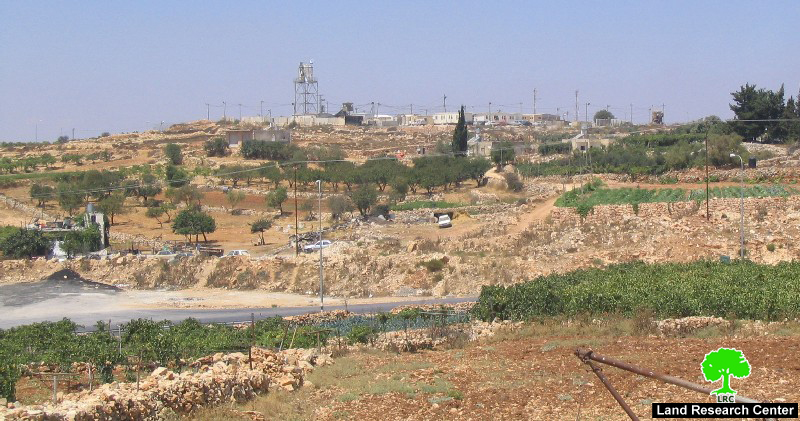
Photo 14: An Israeli military camp near the entrance to Karmei Zur settlement.
This camp was built on Halhul confiscated land)
Prepared by
The Land Research Center
LRC


