A glance about Artas village
The historical village of Artas is located one and a half kilometers to the southwest of Bethlehem city center and 15 kilometers from Jerusalem city; its location situated in a fertile valley of many water streams has made it of great importance throughout the centuries. The village is bordered by Al Khader city from the North, Ad Duheisheh refugee camp from the northeast, Khallet Hamad from the west, Wadi Rahhal from the South, and the Israeli settlement Efrat from the southwest.
The Word Artas comes from the Latin word ''Hortus'' which means the ''Civic Garden'', a name that was earned for the many streams located within the green valley spread over 1086 acres that constitute the village's area.
Area and Population: –
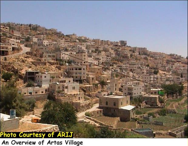
The population of Artas village recorded 433 inhabitants in the year 1922; however, according to the Palestinian National Information Center (PNIC), the population continued to grow reaching up to 1100 and 2100 inhabitants in the years 1967 and 1987, respectively. Today, the village's total population is 3,552 ( Palestinian Central Bureau of Statistics â?? PCBS 2005) most of whom are farmers (ranging between 60% and 70%) and occupies a total area of 4550 dunums. The village's built-up area occupies a total are of 500 dunums, about 11.4% of the village's total area. See Photo 1
Prior to the British Mandate ruling era over Palestine (1920-1948) the area of Artas village included 13850 dunums up until the year 1933 when the boundaries of the village diminished and redrawn to its current standing at 4400 dunums.
Six main clans constitute the population of Artas village, they are Sa'ed, Al Mashani (Rizik), Al Rabay'a, Shahin, Shihadeh and Sanad; in addition to a number of small families who moved to live in Artas during the last couple of decades, they are: Kan'an, Sulaiman Odeh, Al Ta'mari and 'Ubeid families.
Land Classification of Artas Village
In the Oslo II Interim Agreement that was signed in September 1995 between the Palestinians and Israelis, the Palestinian areas in the West Bank were categorized into three areas A, B and C which aimed at a phased withdrawal of the Israeli military forces from these areas until the accomplishment of a final status agreement.
-
Area A: constitutes the areas where the Israeli army has pulled out fully and Palestinians have complete autonomy over administrative and security issues. Area A, according to the Oslo II agreement, covered the main cities of the West Bank, except for Hebron.
-
Area B: Palestinians have full control over the civil responsibilities and Israel continues to have overriding responsibility for security.
-
While Area (C): Palestinians have responsibility for civil life such as economics, health and education; however, Israel retains full control over security and administration related to territory.
Accordingly, the 4400 dunums of Artas Village were classified to areas A, B and C; 1300 Dunums of which were classified as Area A (29.5% of the total village area) where most of the built up area of the village is concentrated; 50 dunums were classified as Area B (1.1% of the total village area); while the rest of the area, a total of 3050 dunums of Artas village lands were classified as Area C (69.3% of the total village area) and contain all the agricultural lands and the open spaces in the village. See Table 1 & Map 1
|
Table 1: Classification of Lands in Artas village according to Oslo II Agreement of 1995 |
||
|
Classification of Area |
Area in dunums |
% of the Village's total area |
|
Area A |
1300 |
29.5 |
|
Area B |
50 |
1.1 |
|
Area C |
3050 |
69.3 |
|
Total Area |
4400 |
100 |
|
ARIJ GIS Database – 2005 |
||

Map 1: Geopolitical Map of Artas Village
Classification of Artas Village lands in blocks
Nine main blocks make up the lands of Artas village; they are listed in table 2 below:-
Table 2: Areas located within Artas lands Blocks
|
Block Number |
Areas located in Block |
|
Block No. 1 |
Um Al Tale' |
|
Block No. 2 |
Um Rukbeh, Thaher Buquo, Hariqat Hasnat, Ghneim Valley, Shu'ab Sultan |
|
Block No. 3 |
Naqura, Artas Valley, Hariqat Milia, Abu Zeid Mountain, Shu'ab Salman, |
|
Block No. 4 |
Artas Valley, Al Khoukh Valley, Hariqat Sanad and Attan |
|
Block No. 5 |
The landscape of the village. |
|
Block No. 6 |
Khaled Mountain |
|
Block No. 7 |
Solomon's Pools area |
|
Block No. 8 |
'Alia's Hamlet (Khallet 'Alia), Al Karweesh Hamlet |
|
Block No. 9 |
Shu'ab Abu Zeid, An Nahleh. |
Artas Folklore Center â?? 2006
Main Archeological Sites in Artas Village
The village of Artas is most illustrious for its religious and archeological sites that interpret the village's history, among of which, are the following:
-
Al Banat Monastery (The Closed Heaven of Artas),
-
Al Khoukh and 'Alia hamlets which have remains back to the Roman Century such as ancient water springs and canals;
-
Artas Valley, which also has, remains of a Crusadas church and a Roman Castle built by Herod;
-
Solomon's pools, just upstream from Artas village and is among the most attractive spots in the village. Three large pools that bear the name of king Solomon.
1. Artas Sisters' Monastery; also known as the Monastery of Virgin Mary or the Closed Heaven of Artas; established in 1898, during the Ottoman ruling period. It lies in the northwestern part of Abu Zaid Mountain (Block 9).
The Sisters of St. Mary complain against the constant and aggressive infringe of the Israeli settlers of Efrat (established 1979) on their land. The stone wall surrounding the monastery was damaged and destroyed due to the settlers aggressive activities against the village. Past expropriations of land by the Israeli government and military to expand Efrat settlement have cost the Monastery to loss of 30 dunums of the its surrounding lands.
2- Solomon's Pools
It is not clear why they were called 'Solomon's Pools' and who named them after King Solomom. An Arab traveler mentioned them as the Pools of Al-Marji' (or Return), which, according to a legend, is the place where brothers of Joseph are thought to have returned after they dropped him in the well. However; it is documented that the third pool, was built by the Mamlouk Sultan al-Zahir Khohaqadam in 1460 (Encyclopedia Palestina, 1994; Sanad, 1992). The Pools collected the runoff water from the adjacent mountains, the al-Arrub wadi and from two adjacent springs. The collected water was considered the major feed of water to the residents of Bethlehem and Jerusalem during the Ottoman period where water was transferred through a system of aqueducts and alike-pipelines of closely fitted stone.
The Pools were renovated in the 1920s by the British Mandate authorities who also installed a pumping station to increase the efficiency of water transportation to the nearby communities. Supplying water to East Jerusalem from the pools ceased after the Israeli occupation of the West Bank and the Gaza Strip in 1967.
Today, the Pools are in a dilapidated state and the water is used by the neighboring village of Artas, in spite of being heavily polluted. The surrounding area of the Pools is forested with numerous trees and bushes that are currently in need of care, protection and proper management.
Historical Features in Artas Village
Artas's Village natural beauty and diversified natural areas attract nature lovers from around the world to visit the area that dates back to hundreds of years. Below is a brief description of the historical sites in the village
-
'Alia Hamlet (Kherbit 'Alia): Located south east of Artas and contains the remains of a Roman town, mosaic floor, water channels, in addition to rock-carved tombs.
-
Al Bireh Hamlet (Kherbit Al Bireh): Located south of Solomon's Pool, alongside Jerusalem-Hebron Road. It contains remains of demolished buildings, Olive oil and wine pressers, Mosaic floor as well as carved basins and caves.
-
Al Khoukh Hamlet (Kherbit Al Khoukh): It is located south east of Deir Al-Banat (Al Banat Monastery). It has the ruins of a Roman town called Etam which takes its name from the First Roman city of Etam, in addition to a spring and a water channel.
-
Al Bassa Hamlet (Kherbit Al Bassa): Located south of Solomon's Pools and reaches up to 676 meters above sea level. It contains ruins of a Roman town called Bethbeza and remains of other demolished buildings and caved graves.
-
Al Banat Monastery: is located south east of Artas village. It was built during the early Byzantine period. The present site contains the remains of big buildings, mosaic floor and many carved rocks. See Photo 2
-
Artas Valley (Wadi Artas): It contains many important historical sites, including the remains of a Crusader church, a Roman Palace and several Roman Mills. Also there are Roman water Channels known as Belatius, Sifurius and Herodius channels.
-
Wadi Al-Biyar:Located near El-Khader village and is known for being one of the sources of water for Solomon's Pools. See Map 2
Map 2: Monuments and Historical Features in Artas Village
Water and Agriculture in Artas Village
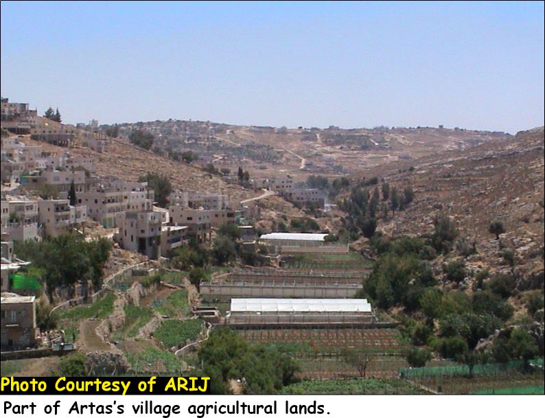
Artas village is well known for its wide range production of vegetables, fruits and field crops. This was mainly associated with the abundance of water resources in the village, which is considered one of the richest villages with water in Palestine; in addition to the average temperature observed during summer and winter times (warm summer, cool winter).
Almost, three-quarters of the village's population work in agriculture. According to Artas Folklore center, there are 21 kinds of vegetables cultivated in the village such as cabbage, Lattice, Spinach, cauliflower, Eggplants, Cucumber, Radish, Tomato, Squash and pepper; in addition to 11 kinds of fruits and other field crops such as Wheat, Barley, apricots, Nuts, Pomegranate, strawberry, Apple, figs, pear, grapes, Almonds, Olives, and beans. Villagers of Artas sell their agricultural products in the local markets (Bethlehem, Beit Jala and Beit Sahour) and when possible Jerusalem and other areas of the West Bank. See Photo 3 & Photo 4
Artas residents use the springs and water streams of the village to water their agricultural lands, they are: Saleh Water Stream, Al Qal'aa water Stream, 'Attan Water Stream, Al Burak Water Stream, Al Farujeh Water Stream and Artas Spring System.
-
Saleh Water Stream ('Ein Saleh or Ras Al 'Ein); lies 120 meters to the west of Solomon's pools and runs 814 meters above sea level.
-
Al Qal'aa Water Stream ('Ein Al Qal'aa or 'Ein Al Burj): Due to its location inside the castle (or the Qal'a in Arabic), this water stream was given this name. It runs 800 meters above sea level.
-
'Attan Water Stream ('Ein Attan or 'Ein Um Ayyoub): It lies in 'Attan hamlet or (Khallet 'Attan) south of Solomon's Pools and run 760 meters above sea level.
-
Al Burak Water Stream: It is situated in the northeastern part of the least elevated pool (Solomon's Pools).
-
Al Farujeh Water Stream: It was discovered during the period of the British mandate.
-
Artas Spring System: located in the eastern part of Khaled's Cave (Magharet Khaled in Arabic) and runs 676 meters above sea level. This system consists of one spring with an annual discharge of approximately 319,000 CM (Hosh, 1994). This spring represents the backbone of Artas village, as it constitutes the only source for domestic and irrigation purposes.See Photo 5 & Photo 6
Livestock
Livestock is an important component in the life style of Artas Village. Many households depend on livestock for their main source of income. A majority of the villagers (women and men) jointly care for cows, sheep, goats, pigeons, Turkey, ducks, rabbits and chickens. In the rainy season, these animals often graze in the open spaces of Artas Village lands and in the dry season; the animals graze on the uncultivated wheat and Barley fields. Villagers also sell small livestock like chickens, ducks and and its products (eggs, milk, etc) in the local markets.
Israeli Colonization activities in Artas village
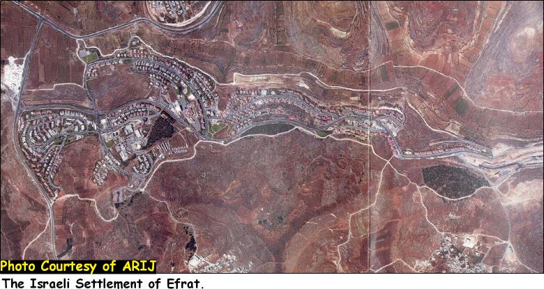
The village of Artas lost a considerable area of its; when these lands were seized by the Israeli government to establish Efrat settlement in 1979. The settlement that accommodates 7300 israeli settler has a totals area of 2180 dunums (ARIJ GIS 2005); 460 Dunums of which belong to Artas village. See Satellite of Efrat Settlement
Furthermore, the Israeli Army issued several military orders to confiscate lands from in the period between 1991 and 2002, which amounted to more than 2000 Dunums. Table 3 below, details the military orders that were issued in the village
Table 3: Israeli land confiscation orders in Artas village over various periods.
|
Date |
Type of Confiscation |
Area Confiscated |
Purpose |
|
January 9, 1991 |
Military Order # 8/91 |
121.5 |
Declared State Land |
|
March 12,1991 |
Military Order # 16/91 |
741 |
Declared State Land |
|
March 14, 1991 |
Military Order # 17/91 |
1449.9 |
Declared State Land |
|
1991 |
Published in Al Itihad Newspaper |
10.125 |
Bypass Road # 60 |
|
2002 |
During Al Aqsa Intifada |
101.25 |
To establish 2 Military watch points |
|
Total |
———————- |
2423.775
|
——— |
|
ARIJ Military Orders Database – 2006 |
|||
Artas village and the Segregation Wall
The Village of Artas, as the rest of the Palestinians cities and villages falls within the vortex of the Segregation Wall. The village of Artas is threatened to lose almost half of its lands as appears in the revised map of the Segregation Wall of February 20, 2005 that was published on the Israeli Ministry of Defense's website.
For that purpose, a series of military orders were issued by the Israeli Occupation Forces to seize lands from Artas village for the construction of the Segregation wall, the first of which, was on August, 3, 2004, when the Israeli authorities issued a military order holding number (59-1967) and stipulating the confiscation of 350 dunums of lands from Artas village and Al Louza hamlet lands (Khallet Al Louza) for constructing the Segregation Wall.
A year later, on July 7, 2005, the Israeli military authorities issued military order number (137/05/T) which stated the confiscation of 162 dunums of lands from blocks 1, 2, 3 and 9 (listed in table 2) for the construction of the Segregation Wall in the village. See Copy of military order

(Military order number (137/05/T))
Table 4: Areas located within Artas blocks
|
Block No. |
Village |
Name of area |
|
|
|
|
|
Block 1 |
Artas |
Um Al Talea' |
|
Block 2 |
Artas |
Hareqat Hasnat |
|
Block 3 |
Artas |
Shu'ab Salman |
|
Block 9 |
Artas |
Al Nahleh, Shu'ab Abu Zeid |
Translation of military order in Annex 1
The order stated the confiscation of the area on which the path of the wall will be constructed but didn't include the lands that will be segregated behind the wall path once completed, which include some of Artas's nature and archeological Sites (1826.5 dunums of lands). Table 5 below shows the land use land cover of Artas village lands, along with the lands that are going to be segregated behind the wall path. See Map 3

Map 3: The Segregation Wall Path in Artas Village
Table 5: Land Use Land Cover (LULC) of Artas Village Lands
|
Land Classification of Artas Village Lands |
LULC inside the village boundary Artas |
LULC in the area isolated west of the Wall (in dunums) |
% of the total village area |
LULC East of the Wall (in dunums) |
|
Arable land |
270 |
59 |
1.34 |
211 |
|
forests |
180 |
0.5 |
0.01 |
179.5 |
|
Hetrogeneous agricultural areae |
500 |
120 |
2.73 |
380 |
|
Mine, Dump and Construction sites |
180 |
0 |
0.00 |
180 |
|
Open space with little or no vegetation |
1600 |
970 |
22.05 |
630 |
|
Permanent crops |
450 |
8 |
0.18 |
442 |
|
Shrubs and/or herbaceous vegetation associations |
410 |
360 |
8.18 |
50 |
|
Palestinian built-up area |
500 |
9 |
0.20 |
491 |
|
Jewish colony 2002 (the settlement expanded to 460 dunums in Year 2004) |
310 |
300 |
6.82 |
10 |
|
|
|
|
|
|
|
Total land cover |
4400 |
1826.5 |
|
2573.5 |
Source: ARIJ database- GIS, 2005

Map 4: Land Use Land Cover
The planned Segregation Wall path in Artas village will stretch a length of 3.185 Kilometers and will isolate a total of 1826.5 dunums of the Village's lands (41.5% of the village's Total area) behind it once completed (Artas's western and southern parts). The wall will also engulf the part of Efrat settlement located within Artas village boundary.
Effect of the Wall on Artas village
Villagers of Artas depend on agriculture and its related sub sectors (tending livestock) for their living. The confiscation of Lands of Artas will severely affect their living as the lands most suitable for cultivation will be confiscated and/ or isolated behind the Segregation Wall, which will seriously affect the amount of agricultural produce of the village.
In addition, a number of archeological and nature sites will be isolated behind the wall path once it is completed; they are: Um Rukbeh, 'Alia Hamlet (Kherbit 'Alia), Thaher Buquo, Hariqat Hasnat,Ghneim Valley (located in Block 2), Hariqat Sanada (Located in Block 4), Shu'ab Abu Zeid (Located in Block 9), Deir Al Banat (Located in Block 3), , Saleh Water Stream ('Ein Saleh, located in Block 9).
Annex 1: Translation of military order number (137/05/T)
|
Israel Defense Forces Order to Seize lands n0 137/05/T
According to my authorities as a Military Chief Commander in the Region of Judea and Samaria, and as I believe that it is imperative for military reasons due to the special security situation in the region, I order the following:
1- In This Order:
The 'Map' – signed in scale 1: 10000 and attached to the order is an essential part of this order.
The 'Lands' – An area of land which is 162 dunums (1,717 meters long and 100 meters wide), marked in red in the map and is located in lands of:
Artas
2- I announce by that the above mentioned lands are seized for imperative military purposes, to construct the Wall on lands of Artas Vilage.
3- The IDF seize the lands and an absolute control of the land is given to the Military Chief Commander of the Central Region through the Ministry of Defense Chief Officer in the Civil Administration Office.
4- Copies of this military order and the attached map are handed out to Land owners or to the District Co-ordination Office in Bethlehem.
5A- This military order is to be notified to Land Owners or those who act on behalf of them by posting it at the District Coordination Office in Bethlehem and dispersing it on the lands by any possible mean.
5B- Copies of the military order and the attached map are available for interested parties at the following places:
5C- Copy of the military order and the attached map is set at Bethlehem District Coordination Office Board for 10 days from the issuance date of the military order, as mentioned in Part (5A).
6- Land owners or those who act on behalf of ownership have the right to object the military order in 7 days from the date of the field visit as mentioned in Part (5A) above through the District Coordination Office in Bethlehem or at the Office of the juridical advisor in the region.
7- Land Owners have the right to go to the District Coordination Office in Bethlehem to get usage expenses and compensation.
8- This order is valid from the date it was signed and until 31/12/2007.
9- This order is called: 'Order to seize lands n0 210/05/T (Judea & Samaria) 5765-2005.
Ya'er Naveh
|
The Wall in International law:-
The Israeli Segregation Wall has harsh impacts on the Palestinian society especially that it cuts off the agricultural lands from its owners, and deprives them from their living and consequently affects their economic situation and life style. The construction of the Segregation Wall is a clear violation of International law and UN resolutions:
Fourth Geneva Conventions, Article 53: Any destruction by the Occupying Power of real or personal property belonging individually or collectively to private persons, or to the State, or to other public authorities, or to social or cooperative organizations, is prohibited, except where such destruction is rendered absolutely necessary by military operations.
Fourth Geneva Conventions, Article 33:
-
No protected person may be punished for an offence he or she has not personally committed. Collective penalties and likewise all measures of intimidation or of terrorism are prohibited.
-
Pillage is prohibited.
-
Reprisals against protected persons and their property are prohibited.
The Wall also violates the International Covenant on Civil and Political Rights and the International Covenant on Economical, Social, and Cultural Rights both of which Israel has signed.
-
The International Covenant on Civil and Political Rights (ICCPR) – Property (ICCPR, article 1): All peoples have the right of self-determination. By virtue of that right they freely determine their political status and freely pursue their economic, social and cultural development.
-
The International Covenant on Economic, Social and Cultural Rights (ICESCR) – health (ICESCR, article 12): The States Parties to the present Covenant recognize the right of everyone to the enjoyment of the highest attainable standard of physical and mental health.
-
The International Covenant on Economic, Social and Cultural Rights (ICESCR) – Education (ICESCR, art.13: The States Parties to the present Covenant recognize the right of everyone to education. They agree that education shall be directed to the full development of the human personality and the sense of its dignity, and shall strengthen the respect for human rights and fundamental freedoms.
-
The International Covenant on Economic, Social and Cultural Rights (ICESCR) – Food (ICESCR, art. 11): The States Parties to the present Covenant recognize the right of everyone to an adequate standard of living for himself and his family, including adequate food, clothing and housing, and to the continuous improvement of living conditions. The States Parties will take appropriate steps to ensure the realization of this right, recognizing to this effect the essential importance of international co-operation based on free consent.
References:-
-
Artas Folkore Center Archives, 2006
-
ARIJ – GIS Databases, 2005
-
'http://www.pcbs.gov.ps/.' Small Area Population, Revised Estimates (2004-2006).
The Palestinian Central Bureau of Statistics (PCBS).
26 04 2006 . -
'Environmental Profile for the West Bank, Volume 1: Bethlehem District..' http://www.arij.org.
June 1995. The Applied Research Institute Jerusalem (ARIJ). April 2006 .. June 1995. The Applied Research Institute Jerusalem (ARIJ). April 2006 . -
Encyclopedia Palestine, Vol 1. Damascus. 1994. (Arabic)
-
Hosh, L. Development of Local Water Resources in Palestine – Definition of Potential
Involvement A Report for the Near East Foundation. New York, September 1994.
Prepared by
The Applied Research Institute – Jerusalem
ARIJ


