• About The Project
  • Palestine in Century
  • Selected Maps
  • Glossary
  • About ARIJ
  • About LRC
  • By Year
    • Case Studies By Year
    • Daily Report By Year
Tuesday, June 3, 2025
POICA
No Result
View All Result
  • Home
  • Settlements
    • New Israeli Settlements
    • Settlement Expansion
  • Israeli Violations
    • Agriculture
    • Confiscation
    • Demolition
    • Environment
    • Eviction of Palestinians
    • Settlers Attacks
  • Bypass Roads
  • Israeli Plans
  • Segregation
    • Checkpoints
    • Closure
    • Separation Plans
  • Military Orders
  • Reports
    • Daily Report
    • Monthly Report
    • Quarterly Report
No Result
View All Result
POICA
No Result
View All Result

The new changes on the Segregation Wall path in Al Jab’a village

May 16, 2006
in Separation Plans
The new changes on the Segregation Wall path in Al Jab’a village


A glance about Al Jab'a village

Al Jab'a is a Palestinian village located 12.5 Kilometers to the southwest of Bethlehem city. It has a total area of 7120 dunums and the built-up area constitutes 150 dunums. The village is situated 1100 meters from the Armistice line (Green Line).

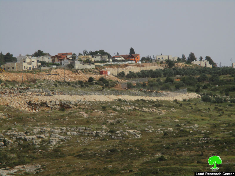
Before the 1948 war, Al Jab'a village used to have 7345 dunums of lands mostly planted with Olives, but after the war 225 dunums came to lie west of the Green line. After the 1967 war the village was targeted due to its location close to the Armistice line and its mountainous topographic nature. Out of the 7120 dunums inside the village boundary of Al Jab'a, 666 dunums were confiscated for the construction of the Israeli settlement of Beit 'Ain (Tsoref).

Today, the village is the home of 876 inhabitants and it borders the Gosh Etzion settlement bloc (the bloc encompasses an area of 72,223 dunums) and it is surrounded by the Israeli settlements of Gavaot, Bet Ain (Tsoref) and Kfar Etzion. Since 1967 until today, the village was going under harsh Israeli measures such as uprooting of trees, land confiscation and land razing.    

Al Jab'a village and the new changes on the Segregation Wall

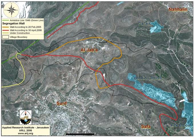
In continuation of the land confiscation process in the occupied Palestinian Territory, the Israeli authorities issued a series of military orders to confiscate hundreds of dunums of agricultural lands in Al Jab'a village in order to construct the segregation Wall and a trade passage on its lands.

On 26 April, 2006, the Israeli Prime Minister Ehud Olmert and the Israeli Cabinet agreed on continuing the construction of the Segregation Wall on the lands of the West Bank with some changes to be made on the Wall's path in the areas of Ariel settlement north of Salfit, Beit Iksa village northwest of Jerusalem, Al Jab'a and Al Walaja in Bethlehem.

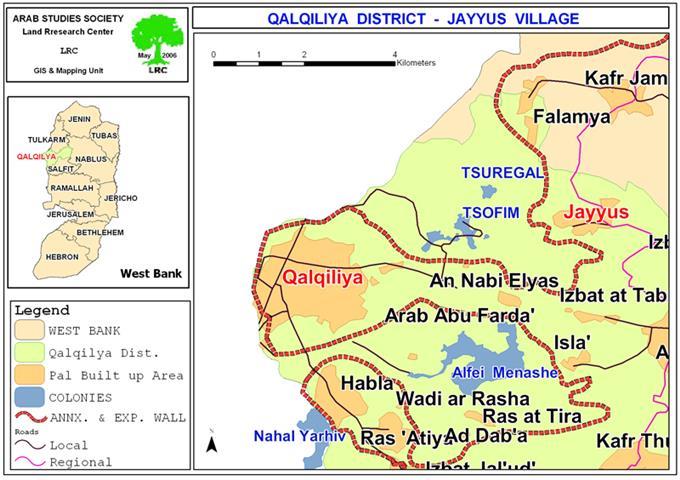
The Wall section that was planned to be constructed north of Al Jab'a village according to the Wall plan published by the Israeli Ministry of Defense on February 20, 2005, is changed due to the new amendments, whereby the Wall will be shifted and constructed south of the village. As a result of the new amendments, Al Jab’a village will be totally isolated from Bethlehem Governorate’s lands and will be enclaved together with Battir, Husan, Nahalin, Wad Fuqin, Al Balluta Hamlet, 'Afaneh Hamlet and Beit Sakaria Hamlet in one big enclave located between the Segregation Wall west of Bethlehem and the Wall that runs along the 1949 Armistice Line (Green Line) and encompasses the Israeli settlement bloc of Gosh Eztion. See Map 1

The change in Wall Route was mainly because the previous route have placed bypass road number 367 (which connects the Gush Etzion settlement bloc with cities inside Israel) south of the Segregation Wall. This would demand opening an alternative road for the settlers of Gush Etzion, but due to the geographic difficulties, expenses, time and for ‘security reasons’, the Israeli government decided to shift the Wall southwards, south of the bypass road, which would place Al Jab’a village north of the Wall and isolates it from the nearby communities. The status of Al Jab’a will be similar to that of Bethlehem western rural villages whose only connection with Bethlehem center will be through a terminal and tunnel at Al Khader.

Conclusion

The construction of the Israeli Segregation Wall in the Occupied Palestinian Territory aims to ensure the Israeli control over large areas of lands, disconnect the Palestinian villages and towns of the West Bank and keep them under the Israeli control.

The confiscation and destruction of Palestinian land is a violation of the Fourth Geneva Convention, Article 147 of which clearly prohibits, ''extensive destruction and appropriation of property, not justified by military necessity and carried out unlawfully and wantonly.''  Violations of Articles of the Fourth Geneva Convention constitute breaches of the Convention and should be prosecuted as War Crimes.


Prepared by:  
The Applied Research Institute – Jerusalem

Recommended For You

إغلاق مداخل قرية دير نظام بالتزامن مع إقامة مقطع جديد من السياج الفاصل / محافظة رام الله

by arij
June 25, 2019
0
The Israeli occupation violates human rights in Deir Nitham / Ramallah governorate

  الانتهاك: إقامة مقطع جديد من السياج الفاصل وإغلاق مداخل القرية. الموقع: قرية دير نظام شمال مدينة رام الله. تاريخ الانتهاك: 13/02/2019. الجهة المعتدية: جيش الاحتلال الإسرائيلي. الجهة...

Read moreDetails

The Israeli occupation violates human rights in Deir Nitham / Ramallah governorate

by arij
June 25, 2019
0
The Israeli occupation violates human rights in Deir Nitham / Ramallah governorate

  Violation: closing the town’s entrance and establishing a new segment of the apartheid wall. Location: Deir Nitham village north Ramallah city. Date: 13/02/2019. Perpetrator:  The Israeli occupation...

Read moreDetails

Info-graph: Manipulating the Demography of Occupied East Jerusalem
“The Construction of the Israeli Segregation Wall in and around Jerusalem

by arij
January 16, 2019
0
Info-graph: Manipulating the Demography of Occupied East Jerusalem “The Construction of the Israeli Segregation Wall in and around Jerusalem

  When Israeli captured East Jerusalem along with other Arab-Palestinian territories during the 1967 war, it became an obsession of the successive Israeli governments to win the demographic...

Read moreDetails

جيش الاحتلال الاسرائيلي ينصب بوابة حديدية جديدة شمال مدينة سلفيت

by arij
July 3, 2018
0
جيش الاحتلال الاسرائيلي ينصب بوابة حديدية جديدة شمال مدينة سلفيت

  الانتهاك: نصب بوابة حديدية على مدخل طريق زراعي شمال سلفيت. الموقع: مدينة سلفيت.. تاريخ الانتهاك: 21 حزيران 2018م. الجهة المعتديه: جيش الاحتلال الإسرائيلي. الجهة المتضرره: المزارعون في...

Read moreDetails

Israel to build new segment of the apartheid wall around “Ma’ale Isreal”

by arij
December 10, 2018
0
Israel to build new segment of the apartheid wall around “Ma’ale Isreal”

violation: completing the construction of the apartheid wall Location: Sarta Ash-Sharqiya village/ Salfit Governorate. Date:  May 01 - 2018 Perpetrators: Israeli Occupation Forces Victims:  residents of Sarta Description:...

Read moreDetails
Next Post
Israeli Occupation Authorities Prevent Farmers In Jayyus from Getting Fertilizers into their Lands

Israeli Occupation Authorities Prevent Farmers In Jayyus from Getting Fertilizers into their Lands

LATEST NEWS

77 عام  على النكبة الفلسطينية: حاضر مستمر لا تاريخ منتهي

77 عام  على النكبة الفلسطينية: حاضر مستمر لا تاريخ منتهي

by arij
June 2, 2025
0

........................................................

Expansion of Gilo Settlement: A Strategic Plan to Isolate Bethlehem and Undermine Palestinian Rights

Expansion of Gilo Settlement: A Strategic Plan to Isolate Bethlehem and Undermine Palestinian Rights

by arij
May 12, 2025
0

........................................................

الأراضي الفلسطينية بين الذرائع الأمنية والأطماع الاستيطانية – “الأمن، الآثار، والطبيعة كحجج لاقتلاع الفلسطينيين من أراضيهم”

by arij
April 15, 2025
0

........................................................

الطرق الالتفافية الاسرائيلية وأثرها على البيئة الفلسطينية

انتهاك للطبيعة والهوية في الأراضي الفلسطينية المحتلة

by arij
March 17, 2025
0

........................................................

flag_yellow_lowEU-PfP-Logo

This website has been produced with the assistance of the European Union. The contents of this publication are the sole responsibility of ARIJ & LRC and can in no way be taken to reflect the views of the European Union.

© 2025 Copyright ARIJ . All Rights reserved. .

No Result
View All Result
  • Home
  • Settlements
    • New Israeli Settlements
    • Settlement Expansion
  • Israeli Violations
    • Agriculture
    • Confiscation
    • Demolition
    • Environment
    • Eviction of Palestinians
    • Settlers Attacks
  • Bypass Roads
  • Israeli Plans
  • Segregation
    • Checkpoints
    • Closure
    • Separation Plans
  • Military Orders
  • Reports
    • Daily Report
    • Monthly Report
    • Quarterly Report

© 2025 Copyright ARIJ . All Rights reserved. .