• About The Project
  • Palestine in Century
  • Selected Maps
  • Glossary
  • About ARIJ
  • About LRC
  • By Year
    • Case Studies By Year
    • Daily Report By Year
Monday, June 2, 2025
POICA
No Result
View All Result
  • Home
  • Settlements
    • New Israeli Settlements
    • Settlement Expansion
  • Israeli Violations
    • Agriculture
    • Confiscation
    • Demolition
    • Environment
    • Eviction of Palestinians
    • Settlers Attacks
  • Bypass Roads
  • Israeli Plans
  • Segregation
    • Checkpoints
    • Closure
    • Separation Plans
  • Military Orders
  • Reports
    • Daily Report
    • Monthly Report
    • Quarterly Report
No Result
View All Result
POICA
No Result
View All Result

Increase of Palestinians suffering at Israeli checkpoints
” The case of Jama’in village “

April 14, 2006
in Checkpoints
Increase of Palestinians suffering at Israeli checkpoints   ” The case of Jama’in village “


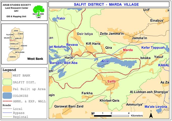
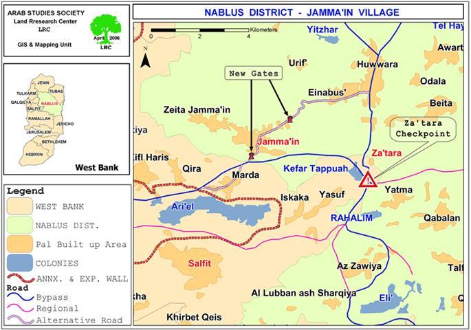
As part of the on going Israeli policy of closure, separation and repression the Israeli army strengthened its measures on all checkpoints in the occupied West Bank, including the Za'tara ( Tabuh ) checkpoint which is located 9 km to the south of the city of Nablus on road number 60 connecting between the northern and southern mountainous heart land of the  West Bank. In other words, this checkpoint is a major crossing point between the northern and southern governorates of the West Bank, on one hand, and between the western and eastern governorates, on the other hand. See Map 1


Map 1: Location of Jama'in village with the two iron gates and the
Za'tara crossing on road No. 60),
Photo courtesy of LRC

The Za'tara ( Tabuh ) checkpoint has been established over lands confiscated from the village of Hawara, Nablus district and the village of Iskaka, Salfit district.Israeli repressive measures at this particular checkpoint include lengthy hours of checking, turning people back, especially the Tulkarem, Qalqiliya and Jenin passengers who lack passing permits, and arresting of passengers for any small reason.

To avoid this, passengers are forced to use the only available alternative road to reach their destination which is the Hawara – Jama'in road. This road is very dangerous as it is narrow, curvy and passes through a complex of stone quarries and mountainous areas. In addition, it takes longer time than the original road through Za'tara junction. See Photo 1


Photo 1: The Za'tara ( Tabuh ) crossing point )

Photo courtesy of LRC


Two iron gates

Even, the Israeli occupation forces didn't let this option work, as they erected two iron gates at the eastern and western entrances to Jama'in so as to command the Palestinian movement on this local alternative road. Israeli soldiers very often close these two gates and halt all Palestinian movement on this road adding more hardships and suffering to passengers and to local citizens of Jama'in alike.

Road Barrier

Apart from this, the Israeli occupation forces erected last February a road barrier along the Trans Samaria highway No. 5 which passes in Jama'in's southern land area. As a result, hundreds of dunums of agricultural lands ( Jama'in total land area is 17823 dunums of which 1358 dunums are built up area) have been separated behind the road and owners' access denied.

Wild pigs

To add to the Palestinian misery, the Israeli occupation forces and authorities brought into the area quite many wild pigs which are dangerous to agriculture and people of the area.

Despite all complaints and protests against their presence, the Israeli authorities refused to listen, claiming that these animals are of extinct species and shouldn't be killed or extracted from the area.


Prepared by
The Land Research Center
LRC

Recommended For You

الحرب على قطاع غزة وتأثيرها على محافظة الخليل جنوب الضفة الغربية

by arij
November 30, 2023
0

  تقع محافظة الخليل في الجزء الجنوبي من الضفة الغربية المحتلة، إلى الجنوب من مدينة القدس، وعلى بعد حوالي 36 كم منها. يحدها من الشمال محافظة بيت لحم،...

Read moreDetails

تطبيق سياسة الفصل العنصري على استخدام الطرق الرئيسية في الضفة الغربية وتقيد حركة وتنقل المواطنين الفلسطينيين

by arij
November 22, 2023
0
معاناة شجرة الزيتون الفلسطينية بسبب الاحتلال والاستيطان في العام 2023

  بناء على تقديرات مراقبين دوليين يبلغ عدد الحواجز الإسرائيلية في الضفة الغربية أكثر من 567 حاجز إسرائيلي متعددة الاشكال منها 77 حاجزًا رئيسيًا وجزئي تتحكم في حركة...

Read moreDetails

The Instigation of Apartheid Roads Era: Israel blocks Palestinian movement inside West Bank Governorates

by arij
November 22, 2023
0

  According to international observers, Israel constrains the West Bank territory with 567 various types of obstacles; 77 of which are main checkpoints and partial checkpoints that control...

Read moreDetails

Between “Ben Gavir” and Netanyahu Not Oblivious but Vindictive, The reality of Israeli Apartheid Stands in the occupied Palestinian territory

by arij
September 13, 2023
0
Between “Ben Gavir” and Netanyahu Not Oblivious but Vindictive, The reality of Israeli Apartheid Stands in the occupied Palestinian territory

  In the wake of the overwhelming Israeli settlers and the Israeli occupation government increasing their wave of attacks and assaults on the Palestinian people (more than 700...

Read moreDetails

نصب بوابة حديدية على مدخل قرية حوسان في محافظة بيت لحم

by arij
November 1, 2022
0
نصب بوابة حديدية على مدخل قرية حوسان في محافظة بيت لحم

   الانتهاك: نصب بوابة حديدية جديدة. الموقع: بلدة حوسان/ محافظة بيت لحم. التاريخ: 11/08/2022م. الجهة المعتدية: جيش الاحتلال الإسرائيلي. الجهة المتضررة: أهالي قرية حوسان والقرى المجاورة. تفاصيل الانتهاك:...

Read moreDetails
Next Post
Marda village Houses and Lands flooded with Rain/Sewage Mix !!

Marda village Houses and Lands flooded with Rain/Sewage Mix !!

LATEST NEWS

77 عام  على النكبة الفلسطينية: حاضر مستمر لا تاريخ منتهي

77 عام  على النكبة الفلسطينية: حاضر مستمر لا تاريخ منتهي

by arij
June 2, 2025
0

........................................................

Expansion of Gilo Settlement: A Strategic Plan to Isolate Bethlehem and Undermine Palestinian Rights

Expansion of Gilo Settlement: A Strategic Plan to Isolate Bethlehem and Undermine Palestinian Rights

by arij
May 12, 2025
0

........................................................

الأراضي الفلسطينية بين الذرائع الأمنية والأطماع الاستيطانية – “الأمن، الآثار، والطبيعة كحجج لاقتلاع الفلسطينيين من أراضيهم”

by arij
April 15, 2025
0

........................................................

الطرق الالتفافية الاسرائيلية وأثرها على البيئة الفلسطينية

انتهاك للطبيعة والهوية في الأراضي الفلسطينية المحتلة

by arij
March 17, 2025
0

........................................................

flag_yellow_lowEU-PfP-Logo

This website has been produced with the assistance of the European Union. The contents of this publication are the sole responsibility of ARIJ & LRC and can in no way be taken to reflect the views of the European Union.

© 2025 Copyright ARIJ . All Rights reserved. .

No Result
View All Result
  • Home
  • Settlements
    • New Israeli Settlements
    • Settlement Expansion
  • Israeli Violations
    • Agriculture
    • Confiscation
    • Demolition
    • Environment
    • Eviction of Palestinians
    • Settlers Attacks
  • Bypass Roads
  • Israeli Plans
  • Segregation
    • Checkpoints
    • Closure
    • Separation Plans
  • Military Orders
  • Reports
    • Daily Report
    • Monthly Report
    • Quarterly Report

© 2025 Copyright ARIJ . All Rights reserved. .