• About The Project
  • Palestine in Century
  • Selected Maps
  • Glossary
  • About ARIJ
  • About LRC
  • By Year
    • Case Studies By Year
    • Daily Report By Year
Tuesday, October 14, 2025
POICA
No Result
View All Result
  • Home
  • Settlements
    • New Israeli Settlements
    • Settlement Expansion
  • Israeli Violations
    • Agriculture
    • Confiscation
    • Demolition
    • Environment
    • Eviction of Palestinians
    • Settlers Attacks
  • Bypass Roads
  • Israeli Plans
  • Segregation
    • Checkpoints
    • Closure
    • Separation Plans
  • Military Orders
  • Reports
    • Daily Report
    • Monthly Report
    • Quarterly Report
No Result
View All Result
POICA
No Result
View All Result

A Restraining Order to halt Constructions at Al Khader Crossing Point !

April 1, 2006
in Military Orders
A Restraining Order to halt Constructions at Al Khader Crossing Point !


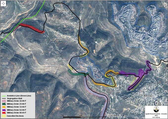
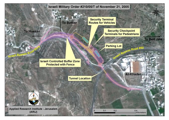
The Israeli Supreme Court issued a restraining order to halt the construction of the military crossing point on the entrance of Al Khader Village, West of Bethlehem. On November 21, 2005, the Israeli authorities issued a military order number (210/05/T , page 1 & page 2) which states the confiscation of 85 Dunums of lands from Al Khader, Battir and Beit Jala cities to construct a crossing point (terminal) at the entrance of Al Khader village to control the movement of Palestinian residents moving between Bethlehem western rural villages ( Battir, Husan, Nahhalin and Wadi Fukin) which is planned to become isolated west of the Segregation Wall (once completed) and the rest of Bethlehem Governorate. See Map 1  , & ) which states the confiscation of 85 Dunums of lands from Al Khader, Battir and Beit Jala cities to construct a crossing point (terminal) at the entrance of Al Khader village to control the movement of Palestinian residents moving between Bethlehem western rural villages ( Battir, Husan, Nahhalin and Wadi Fukin) which is planned to become isolated west of the Segregation Wall (once completed) and the rest of Bethlehem Governorate.

See Translation of military order in Annex 1

The Israeli Supreme Court Decision

Residents of Bethlehem western rural village councils (Nahalin, Hussan, Battir, Wadi Fukin ) along with Al Khader and Beit Jala Municipalities objected the military order and filed petitions to the Israeli Supreme court to stop the construction of the terminal. Lately, on March 12, 2006, the Israeli Supreme court, and as a result of the submitted petition, issued a restraining order to halt the construction of the military crossing point (terminal) at the entrance of Al Khader Village, west of Bethlehem.

The petition rejects the whole route of the Segregation Wall which is planned to be constructed in Western Bethlehem Governorate, as the Wall encompasses all of Gosh Etzion settlement bloc and threatens the isolation of more than 53200 Dunums of Palestinian lands. The Palestinian villages of Al Walajeh, Battir, Husan Nahalin and Wadi Fukin will be entrapped between two Walls; one that runs along bypass road number 60 (or the locally known by the 'Tunnel Road'); while the other runs close to the 1949 Armistice Line (Green line). Residents of the western villages depend much on Bethlehem urban center as the main service and employment provider. It is worth mentioning that the population of these villages exceeds 18,000 Palestinian residents who will be adversely impacted if the Israeli Wall plans are implemented and would lose their livelihood. The petition therefore calls for the Wall and terminal plans to be cancelled in this area.     

Conclusion:-

The construction of the Segregation Wall accompanied by a terminal is considered a real catastrophe to the residents of these villages, as the villagers will be completely isolated from Bethlehem Governorate, have to pass through the terminal in any time they want to leave their villages, will have to pass through security checks and will face annoyances from the Israeli soldiers in the terminal. Moreover, anyone who wants to access one of these villages must be from the residents of these villages otherwise s/he will not enter. In another meaning the local residents will be prisoners in their villages; they can not enter or leave without the permission from the Israeli jailer.

Annex 1

Israel Defense Forces

 Order to Seize lands n0  210/05/T


According to my authorities as a Military Chief Commander in the Region of Judea and Samaria, and as I believe that it is imperative for military reasons due to the  special security situation in the region, I order the following:

1- In This Order:

The 'Map' – signed in scale 1: 10000 and attached to the order is an essential part of this order.

The 'Lands' – An area of land which is 85 dunums, marked in red in the map: 

Al Khader

  • Block 2: Al Butma Site, Sahel Ad Deir.

Battir

  • Block 12: Khallet Abu Hart site

  • Block 13: Al Homor Site

Beit Jala

  • Block 2: Khallet Ash Shook site

2- I announce by that the above mentioned lands are seized for imperative military purposes, to construct Al Khader Passage.

3- The IDF seize the lands and an absolute control of the land is given to the Military Chief Commander of the Central Region through the Ministry of Defense Chief Officer in the Civil Administration Office.  

4- Copies of this military order and the attached map are handed out to Land owners or to the District Co-ordination Office in Bethlehem.

5A- This military order is to be notified to Land Owners or those who act on behalf of them by posting it at the District Coordination Office in Bethlehem and dispersing it on the lands by any possible mean.

5B- Copies of the military order and the attached map are available for interested parties at the following places:

  • DCO of Bethlehem.

  • Offices of the juridical advisor in Judea and Samaria.

  • Office of Chief Commander in the ministry of defense at the Civil Administration.

  • Chief Office of the Absentee and Public Properties in the Civil Administration.    

5C- Copy of the military order and the attached map is set at Bethlehem District Coordination Office Board for 10 days from the issuance date of the military order, as mentioned in Part (5A).

6- Land owners or those who act on behalf of ownership have the right to object the military order in 7 days from the date of the field visit as mentioned in Part (5A) above through the District Coordination Office in Bethlehem or at the Office of the juridical advisor in the region.

7- Land Owners have the right to go to the District Coordination Office in Bethlehem to get usage expenses and compensation.

8- This order is valid from the date it was signed and until 31/12/2007.

9- This order is called: 'Order to seize lands n0 210/05/T (Judea & Samaria) 5765-2005.

Ya'er Naveh
Chief Commander of the Israel Defense Forces in Judea & Samaria
                                    -Signature


Prepared by:  
The Applied Research Institute – Jerusalem

Recommended For You

ما يزيد عن 1900 دونما من الأراضي الفلسطينية في بيت لحم مهددة بالعزل لصالح مستوطنة افراتا

by arij
October 8, 2025
0
ما يزيد عن 1900 دونما من الأراضي الفلسطينية في بيت لحم مهددة بالعزل لصالح مستوطنة افراتا

في الثاني من شهر تشرين أول من العام 2025، أصدرت سلطات الاحتلال الإسرائيلي أمرًا عسكريًا جديدًا يحمل الرقم (ت/3/25) تحت عنوان "تعديل حدود – يهودا والسامرة، 5785-2025". ويأتي...

Read moreDetails

سلطات الاحتلال الإسرائيلي تستغل ‘المنفعة العامة’ لنهب الموارد الفلسطينية

by arij
September 30, 2025
0
سلطات الاحتلال الإسرائيلي تستغل ‘المنفعة العامة’ لنهب الموارد الفلسطينية

في الاول من شهر ايلول من العام 2025، نشرت الإدارة المدنية الإسرائيلية، الذراع الأيمن لحكومة الاحتلال الإسرائيلي أمرا عسكريا جديدا تحت عنوان " أمر ءبشأن قانون الأراضي (الاستملاك...

Read moreDetails

The Occupation Targets the Village of Raba Southeast of Jenin with Military Orders and Seizes Vast Areas of Its Lands

by arij
September 13, 2025
0
الاحتلال يستهدف بأوامر عسكرية قرية رابا جنوب شرق جنين ويصادر مساحات واسعة من أراضيها

 The Israeli occupation Army have continued their policy of plundering Palestinian lands, as their bulldozers leveled wide areas of agricultural land in the village of Raba, southeast of...

Read moreDetails

الاحتلال يستهدف بأوامر عسكرية قرية رابا جنوب شرق جنين ويصادر مساحات واسعة من أراضيها

by arij
September 13, 2025
0
الاحتلال يستهدف بأوامر عسكرية قرية رابا جنوب شرق جنين ويصادر مساحات واسعة من أراضيها

  واصلت قوات الاحتلال الإسرائيلي سياسة نهب الأراضي الفلسطينية، حيث أقدمت آلياتها على تجريف أراض زراعية واسعة في قرية رابا جنوب شرق محافظة جنين، تمهيدا لشق شارع عسكري...

Read moreDetails

Nablus Governorate’s Archaeological Sites Face Israeli Expropriation Plans

by arij
September 11, 2025
0
” المواقع الأثرية في محافظة نابلس… ساحة مفتوحة أمام مخططات المصادرة الإسرائيلية “

On 10 August, 2025, the Israeli Civil Administration (ICA), issued a booklet of military orders signed by the head of the so-called ‘Israeli Civil Administration’ in the occupied...

Read moreDetails
Next Post
The enclavement of Al Walajeh Village

The enclavement of Al Walajeh Village

LATEST NEWS

محافظة أريحا على خريطة المصادرة الإسرائيلية- إسرائيل تسعى للاستحواذ على أكثر من 7000 دونم في منطقة النبي موسى

محافظة أريحا على خريطة المصادرة الإسرائيلية- إسرائيل تسعى للاستحواذ على أكثر من 7000 دونم في منطقة النبي موسى

by arij
October 13, 2025
0

........................................................

ما يزيد عن 1900 دونما من الأراضي الفلسطينية في بيت لحم مهددة بالعزل لصالح مستوطنة افراتا

ما يزيد عن 1900 دونما من الأراضي الفلسطينية في بيت لحم مهددة بالعزل لصالح مستوطنة افراتا

by arij
October 8, 2025
0

........................................................

Annexation of the Jordan Valley: Implications for the Two-State Solution and Regional Stability

Annexation of the Jordan Valley: Implications for the Two-State Solution and Regional Stability

by arij
September 29, 2025
0

........................................................

Isolation of Three Villages Northwest of Jerusalem: Silent Annexation Creeps toward the Capital

عزل ثلاث قرى فلسطينية شمال غرب مدينة القدس: الضم الاسرائيلي الصامت يزحف نحو محيط العاصمة

by arij
September 24, 2025
0

........................................................

flag_yellow_lowEU-PfP-Logo

This website and its content were initiated in 1993 by the Applied Research Institute – Jerusalem (ARIJ) and the Land Research Center (LRC) with the support from the European Union up until 2023. Since then, the Applied Research Institute – Jerusalem (ARIJ) has taken over the continued development and maintenance of the website. The views expressed remain solely those of ARIJ) and do not necessarily reflect those of the European Union.

© 2025 Copyright ARIJ . All Rights reserved. .

No Result
View All Result
  • Home
  • Settlements
    • New Israeli Settlements
    • Settlement Expansion
  • Israeli Violations
    • Agriculture
    • Confiscation
    • Demolition
    • Environment
    • Eviction of Palestinians
    • Settlers Attacks
  • Bypass Roads
  • Israeli Plans
  • Segregation
    • Checkpoints
    • Closure
    • Separation Plans
  • Military Orders
  • Reports
    • Daily Report
    • Monthly Report
    • Quarterly Report

© 2025 Copyright ARIJ . All Rights reserved. .