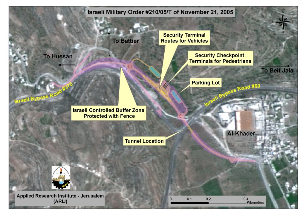
On November 21, 2005, the Israeli Army issued military order # 210/05/T to confiscate 85 Dunums (according to the order) of lands that belong to three Palestinian communities west of Bethlehem district, Beit Jala, Battir and Al-Khader to construct a tunnel and a terminal for travelers between Bethlehem western rural area and Bethlehem governorate. The location of the tunnel is under the Israeli controlled bypass road # 60, whereas the area targeted by the military order extends from Al Khader village east of road # 60 and joins the tunnel underneath road # 60, which ends in a terminal under the Israeli forces supervision and controls the movement both ways of it. The new Israeli military order constitutes a border point between Bethlehem western rural villages (population exceeds 18000), which will be entrapped by the Segregation Wall and the rest of Bethlehem district. It also should be noted that the Israelis are expected to establish a civil administration at the terminal site instead of the existing one at Kfar Etzion (to obtain traveling permits or access permits to lands, etc) since the Palestinian residents will no longer be able to travel on bypass road # 60 to get there. See Map 1
What will the situation be under the new arrangement?
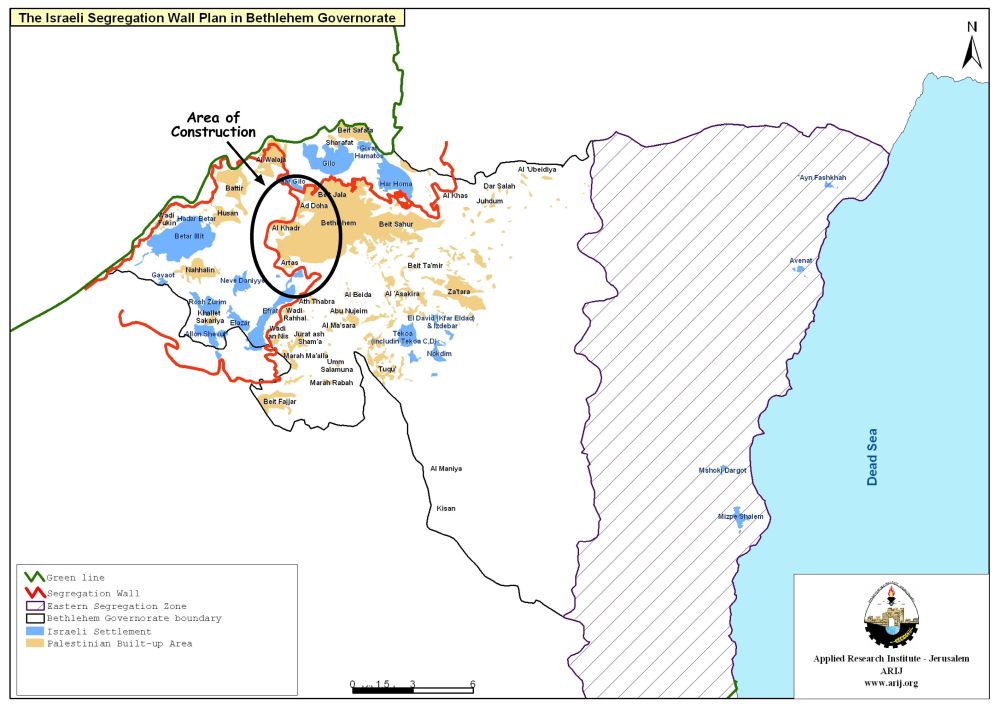
In the original route of the Israeli Segregation Wall, the four Palestinian villages (Nahalin, Battir, Hussan and Wad-Fukin) part of Bethlehem western rural area were set to be enfolded with the Segregation Wall. However, under the February 20, 2005 updated route of the Segregation Wall, released by the Israeli Army, the four villages were no longer enfolded by the Segregation Wall but instead the entire western rural area of Bethlehem was set to be entrapped between the Segregation Wall running along bypass road # 60 and the Segregation Wall to be build along the 1949 Armistice Line (the Green Line). However, no indication was made in the Israeli Army map of February 20, regarding the movement procedures between Bethlehem western rural area and the center of the governorate. It was not until November 21, 2005, the time when the Israeli Army issued military order # 210/05/T, that the residents of the four villages became aware that a terminal will separate them from Bethlehem center and a controlled tunnel would be their only link to the rest of the Governorate. A petition of protest against the new arrangements was filed in the Israeli court on behalf of the four villages of the western rural area; came back with a response that the tunnel will be opened 24 hours; except in times when security alerts requires closing it.
Gibberish rules
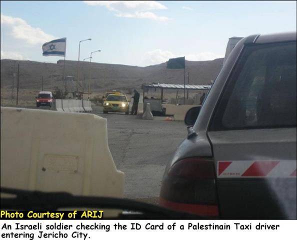
The Israeli Army nor the Israeli court riposte did clarify what will the procedures be for Palestinians traveling from Bethlehem to the four villages after they cross the tunnel, as the Israeli Army's map for the military order 210/05/T confirms that Palestinians who want to travel through the tunnel in any direction would have to stop for security check while traveling through the terminals, where they would most likely be required to establish residency rights; meaning that going to the villages from Bethlehem will be based on identification card, which prove location of residency. This will naturally constitute an actual obstruction of free movement between the western rural villages of Bethlehem and the governorate center, as movement will most likely be exclusive to residents of these villages (as was the case in other areas in the West Bank where the Wall was already constructed and the Gates are operating). Furthermore, traveling through the tunnel and the Israeli controlled terminals will take much more time than it should; taking into consideration the considerable number of population, in addition to the trade, industrial and agricultural related transportation.
Moreover, Palestinian residents who own lands beyond the tunnel (west of the Segregation Wall along bypass road # 60) will be required to provide an Israeli accredited proof of ownership in order to be eligible to receive a permit that will allow them to access to their lands. In any case this also represent a predicament to many Palestinians, who owns lands on the other side of the planned route of the Segregation Wall, since the lands they own are not registered directly by their names, but in the name of their ancestors who are long gone. What is more is that permits are most likely to be issued only to Palestinians with proof of ownership and no one else, which makes it difficult for many of them to care for their lands since the majority of lands are still registered in the names of the elderly in the families. The hazardousness of not being able to care for land that falls within Israeli dominion (in the seam zone) is that the lands will be subject to be claimed by the Israeli State once they establish the composition of an 'Absentee Property' case.
What is the significance of the Tunnel?
There is more to the tunnel than meets the eye, aside from being a substitute-traveling route to Palestinians from Bethlehem's western rural villages to the governorate; it constitutes a link between two different protectorates (the 'seam zone' and area 'C', which falls under Israeli control). Furthermore, the completion of the Israeli Segregation Wall along bypass road # 60 and the tunnel will form a transition point as the area located west of the Segregation Wall along bypass road # 60 (the seam zone) enfold the Gush Etzion settlement bloc (one of six settlements blocs, Israel is keen to keep control of under any peace agreement), which is included within the Israeli plan for 'metropolitan' Jerusalem.
Why did the Israelis decide NOT to enfold the four villages (Nahalin, Battier, Hussan and Wad-Fukien) with the Segregation Wall?
When the Israeli Army published a map in February 20, 2005, illustrating the updated route plan of the Segregation Wall in the West Bank, one of the most significant alterations to the original route took place at Bethlehem western rural area. The original plan of the Segregation Wall at that area was drawn to enfold the four villages located there (Nahalin, Hussan, Battir and Wadi-Fukien), whereas the updated route of the Wall have shown that the villages are no longer enfolded by the Wall, but entrapped between two Walls. The first of these two Walls is located west of the four villages and stretches closely along the 1949 Armistice Line (the Green Line), whereas the other is located 5 Km (average*) deep inside the West Bank territory further to the east of the 1949 Armistice Line and runs along the Israeli bypass road # 60. WHY & WHAT; motivated the Israelis to inflict such changes to the route of the Segregation Wall? Simply that the original route did not harmonize with the objective of the Segregation Wall, which is to capture all that is possible of the West Bank land. As for the WHY, did the Israelis decide not to enfold the four villages with the Segregation Wall, it is simply because they realized that the Segregation Wall will indirectly protect the existence of these villages; even if it separates them from their lands, the Wall will still protect the villages' built up areas, which contradicts with the Israeli's aspirations and conspiration to drive the Palestinian residents into a voluntary desertion of their homes. The WHAT that made them tamper with the original route is the fact that one set of Wall along bypass road # 60 will in effect jeopardize their plan to link the Gush Etzion bloc with Jerusalem from the southwest area; thus leaving the 1949 Armistice Line (which, they seek to undermine and substitute with an official border east of it) as is and open issue to future negotiations.
A more disturbing outcome of entrapping Bethlehem's western rural area between two sets of the Segregation Wall is the fact that 53,200 Dunums will be entrapped as well between the two Walls. This gives much room for the Gush Etzion settlements bloc to expand and increase over time, as they will be presented with all kind of facilitations, contrary to the Palestinian residents of the four entrapped villages. See Map 2
The implication of the Segregation Wall or Walls and the tunnel goes far beyond Bethlehem western rural areas and the four villages, as it will influence the entire population of the Governorate for what the targeted area represent to the population; the fruit basket and a vital inhabitation and territorial area, which is basically what is reserved for expansion of the Governorate especially that the Israelis have dominated the eastern slopes of the Governorate; turning them to closed military areas. The Israeli plan is to drive the residents of Bethlehem's western rural area to voluntarily evacuate their villages and capture the entire area to include it as planed within Jerusalem metropolitan area, which include next to Gush Etzion bloc, Ma'ale Adumim bloc, Giva't Ze'ev and Moda'in bloc.
:::::::::::::____
* the distance between the Segregation Wall running along the 1949 Armistice Line (the Green Line) and the Segregation Wall running along the Israeli bypass road # 60 fluctuate between 4-6 Km.
Prepared by
The Applied Research Institute – Jerusalem
ARIJ