• About The Project
  • Palestine in Century
  • Selected Maps
  • Glossary
  • About ARIJ
  • About LRC
  • By Year
    • Case Studies By Year
    • Daily Report By Year
Tuesday, October 14, 2025
POICA
No Result
View All Result
  • Home
  • Settlements
    • New Israeli Settlements
    • Settlement Expansion
  • Israeli Violations
    • Agriculture
    • Confiscation
    • Demolition
    • Environment
    • Eviction of Palestinians
    • Settlers Attacks
  • Bypass Roads
  • Israeli Plans
  • Segregation
    • Checkpoints
    • Closure
    • Separation Plans
  • Military Orders
  • Reports
    • Daily Report
    • Monthly Report
    • Quarterly Report
No Result
View All Result
POICA
No Result
View All Result

A new land confiscation order to complete the bordering of the largest finger-like corridor in the West Bank !

February 12, 2006
in Military Orders
A new land confiscation order to complete the bordering of the largest finger-like corridor in the West Bank !

At the beginning of the current month (February 2006) the Israeli occupation authorities issued military order number T/15/06 stating the confiscation of 279 dunums from Qalqiliya and Salfit lands for the purpose of constructing a new stage of the Segregation Wall. 

According to the order, a total of 279 dunums of lands will be confiscated for this purpose from the four Palestinian villages, Hajja, Qalqiliya (basin # 2 and 9); kafr Laqif, Qalqiliya (basin # 4 and 1); Deir Istiya, Salfit (basin # 18) and Azzun, Qalqiliya (basin # 2). The planned wall route is about 2.800 meters long and between 580100 meters wide. The above number doesn�t include the land that will be segregated behind the Wall which is estimated at thousands of dunums. See Copies of Military Order


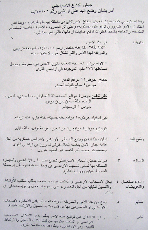
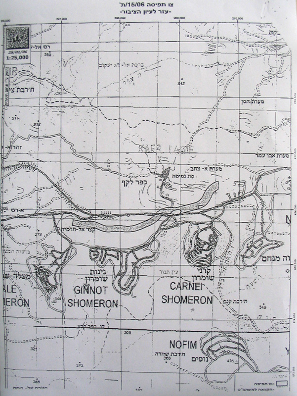
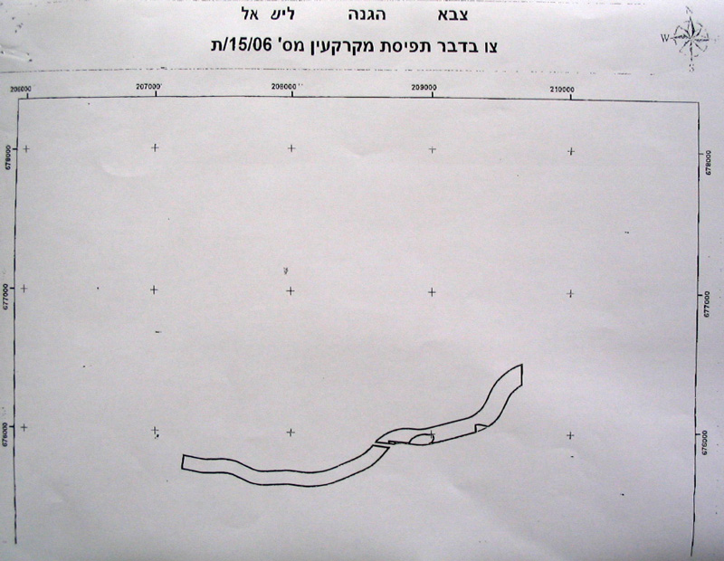
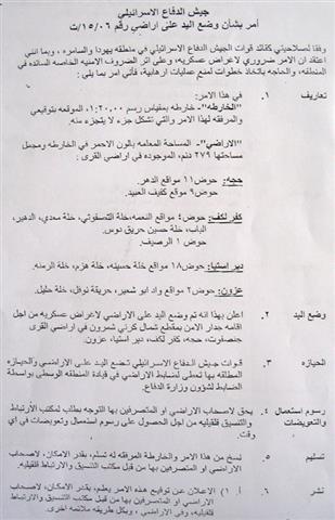
(Photos 1, 2 & 3 : copies of the military order and the attached maps)


Location, population and area

The following table provides information about the four Palestinian villages by Location, population and area:


No

Village name

Location

Population
Year 2005

Area in dunum


Total

Built up

1

Hajja

Qalqiliya

2444

11717

932

2

Kafr Laqif

Qalqiliya

951

2579

298

3

Azzun

Qalqiliya

7985

9140

1525

4

Deir Istia

Salfit

3730

34000

900


Total


15110


Source: Palestinian Central Bureau of Statistics � Population Projection 2005


The Wall route is planned to penetrate through the lands of these four Palestinian villages so as to complete the bordering of the biggest finger-like corridor of 'Ariel settlement bloc.' in the West Bank which aims at ensuring the annexation of all Israeli settlements in the area. This finger- like corridor includes 15 Israeli settlements al located within the bloc. : Ariel, Neve Oranim, Carnei Shomron, Ginnot Shomron, Ma'ale Shomron, Immanuel, Nufim, Yakir, Qiriat Notifim, Revava, Barqan, Alei Zahav ( Yo'ezer), Pedu'el, Beit Arie and Ofarim. See Map 1


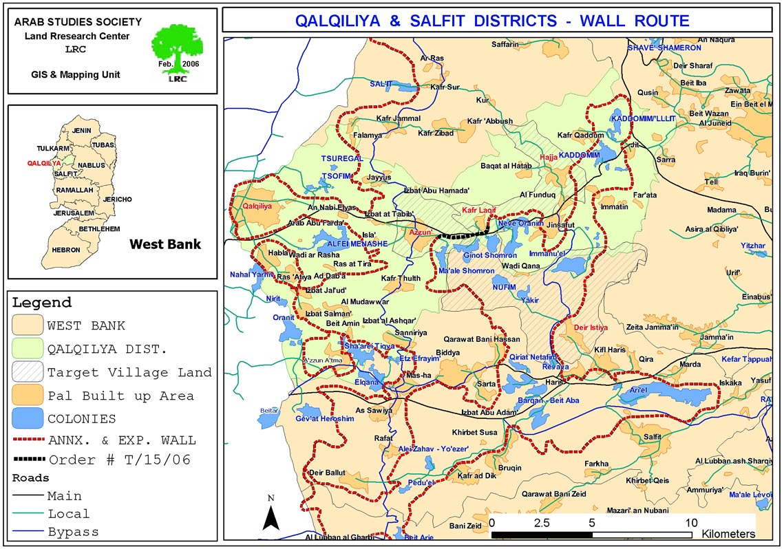
Map 1: The Wall route over the lands of the four villages

Map prepared by LRC


The Ariel finger like corridor will result in the annexation of thousands of dunums of Palestinian lands and dozens of underground water wells which, in effect, will cause disastrous impact on the very existence and welfare of Palestinian people in the area.  The construction of the segregation wall around Ariel bloc started at the beginning of 2003.


The following are some of the impacts caused or to be caused to Palestinian citizens as a result of the construction of the Segregation Wall in this area

  • Bulldozing thousands of dunums of olive orchards considered to be the only source of living for Palestinian families, particularly, after loosing jobs inside Israel;

  • The difficulty of accessing into agricultural lands which have been already separated behind the Wall;

  • Giving Israeli settlers in the area a wide scale space of land for expansion and development at the expense of Palestinian land and future development.

  • The above mentioned Wall section between the villages of Azzun and Kafr Laqif will cut main road number 55 linking between the cities of Qalqiliya and Nablus. The Palestinian movement on this road will be under the mercy of the Israeli army who plan to establish a permanent checkpoint comprised of an iron gate and watch towers. No Palestinian will be able to pass without having valid passing permits from the Israeli military.


Prepared by
The Land Research Center
LRC

Recommended For You

ما يزيد عن 1900 دونما من الأراضي الفلسطينية في بيت لحم مهددة بالعزل لصالح مستوطنة افراتا

by arij
October 8, 2025
0
ما يزيد عن 1900 دونما من الأراضي الفلسطينية في بيت لحم مهددة بالعزل لصالح مستوطنة افراتا

في الثاني من شهر تشرين أول من العام 2025، أصدرت سلطات الاحتلال الإسرائيلي أمرًا عسكريًا جديدًا يحمل الرقم (ت/3/25) تحت عنوان "تعديل حدود – يهودا والسامرة، 5785-2025". ويأتي...

Read moreDetails

سلطات الاحتلال الإسرائيلي تستغل ‘المنفعة العامة’ لنهب الموارد الفلسطينية

by arij
September 30, 2025
0
سلطات الاحتلال الإسرائيلي تستغل ‘المنفعة العامة’ لنهب الموارد الفلسطينية

في الاول من شهر ايلول من العام 2025، نشرت الإدارة المدنية الإسرائيلية، الذراع الأيمن لحكومة الاحتلال الإسرائيلي أمرا عسكريا جديدا تحت عنوان " أمر ءبشأن قانون الأراضي (الاستملاك...

Read moreDetails

The Occupation Targets the Village of Raba Southeast of Jenin with Military Orders and Seizes Vast Areas of Its Lands

by arij
September 13, 2025
0
الاحتلال يستهدف بأوامر عسكرية قرية رابا جنوب شرق جنين ويصادر مساحات واسعة من أراضيها

 The Israeli occupation Army have continued their policy of plundering Palestinian lands, as their bulldozers leveled wide areas of agricultural land in the village of Raba, southeast of...

Read moreDetails

الاحتلال يستهدف بأوامر عسكرية قرية رابا جنوب شرق جنين ويصادر مساحات واسعة من أراضيها

by arij
September 13, 2025
0
الاحتلال يستهدف بأوامر عسكرية قرية رابا جنوب شرق جنين ويصادر مساحات واسعة من أراضيها

  واصلت قوات الاحتلال الإسرائيلي سياسة نهب الأراضي الفلسطينية، حيث أقدمت آلياتها على تجريف أراض زراعية واسعة في قرية رابا جنوب شرق محافظة جنين، تمهيدا لشق شارع عسكري...

Read moreDetails

Nablus Governorate’s Archaeological Sites Face Israeli Expropriation Plans

by arij
September 11, 2025
0
” المواقع الأثرية في محافظة نابلس… ساحة مفتوحة أمام مخططات المصادرة الإسرائيلية “

On 10 August, 2025, the Israeli Civil Administration (ICA), issued a booklet of military orders signed by the head of the so-called ‘Israeli Civil Administration’ in the occupied...

Read moreDetails
Next Post
A Tunnel in Al-Khader Raise more Agony and Despair !!

A Tunnel in Al-Khader Raise more Agony and Despair !!

LATEST NEWS

Annexation of the Jordan Valley: Implications for the Two-State Solution and Regional Stability

الرئاسة الثانية لترامب: فرصة متجددة لطموحات إسرائيل التوسعية – ضم غور الأردن والتداعيات على حل الدولتين واستقرار المنطقة

by arij
October 14, 2025
0

........................................................

محافظة أريحا على خريطة المصادرة الإسرائيلية- إسرائيل تسعى للاستحواذ على أكثر من 7000 دونم في منطقة النبي موسى

محافظة أريحا على خريطة المصادرة الإسرائيلية- إسرائيل تسعى للاستحواذ على أكثر من 7000 دونم في منطقة النبي موسى

by arij
October 13, 2025
0

........................................................

ما يزيد عن 1900 دونما من الأراضي الفلسطينية في بيت لحم مهددة بالعزل لصالح مستوطنة افراتا

ما يزيد عن 1900 دونما من الأراضي الفلسطينية في بيت لحم مهددة بالعزل لصالح مستوطنة افراتا

by arij
October 8, 2025
0

........................................................

Annexation of the Jordan Valley: Implications for the Two-State Solution and Regional Stability

Annexation of the Jordan Valley: Implications for the Two-State Solution and Regional Stability

by arij
September 29, 2025
0

........................................................

flag_yellow_lowEU-PfP-Logo

This website and its content were initiated in 1993 by the Applied Research Institute – Jerusalem (ARIJ) and the Land Research Center (LRC) with the support from the European Union up until 2023. Since then, the Applied Research Institute – Jerusalem (ARIJ) has taken over the continued development and maintenance of the website. The views expressed remain solely those of ARIJ) and do not necessarily reflect those of the European Union.

© 2025 Copyright ARIJ . All Rights reserved. .

No Result
View All Result
  • Home
  • Settlements
    • New Israeli Settlements
    • Settlement Expansion
  • Israeli Violations
    • Agriculture
    • Confiscation
    • Demolition
    • Environment
    • Eviction of Palestinians
    • Settlers Attacks
  • Bypass Roads
  • Israeli Plans
  • Segregation
    • Checkpoints
    • Closure
    • Separation Plans
  • Military Orders
  • Reports
    • Daily Report
    • Monthly Report
    • Quarterly Report

© 2025 Copyright ARIJ . All Rights reserved. .