• About The Project
  • Palestine in Century
  • Selected Maps
  • Glossary
  • About ARIJ
  • About LRC
  • By Year
    • Case Studies By Year
    • Daily Report By Year
Monday, September 1, 2025
POICA
No Result
View All Result
  • Home
  • Settlements
    • New Israeli Settlements
    • Settlement Expansion
  • Israeli Violations
    • Agriculture
    • Confiscation
    • Demolition
    • Environment
    • Eviction of Palestinians
    • Settlers Attacks
  • Bypass Roads
  • Israeli Plans
  • Segregation
    • Checkpoints
    • Closure
    • Separation Plans
  • Military Orders
  • Reports
    • Daily Report
    • Monthly Report
    • Quarterly Report
No Result
View All Result
POICA
No Result
View All Result

More land confiscation for the erection of new military towers

March 9, 2017
in Military Orders
More land confiscation for the erection of new military towers

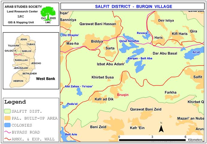
Haris village is located 5 km to the northwest of Salfit city and houses a total population of 3800.  Its total area is 8450 dunums, out of which, 484 dunums are occupied by the built up area.

The village represents a live example of the severity of the Israeli occupation in regards to land confiscation and property dispossession. During the 1970's, the Israeli Governorate established the Trans-Samaria Highway number 5 over the lands of the village which leaded to the partition of the village into two parts as well as the destruction of hundreds of dunums of fertile agricultural lands and the obstruction of any territorial expansion of the village to the south and to the north. See map 1: Location of Haris village and the surrounding settlements.

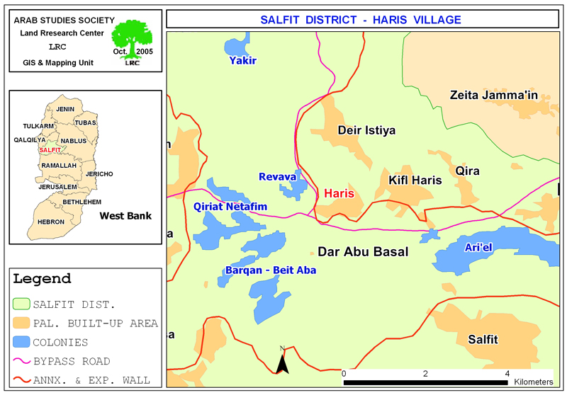
In the meanwhile, a number of Israeli settlements besiege the village from three sides and obstruct its expansion; the settlements are: Revava in the west, Qiryat Netafim in the west, Barqan in the southwest and Ariel in the southeast. Continuous daily harassments on part of the Israeli army and settlers are sources of constant fear and tension for the village's citizens.

New land confiscation

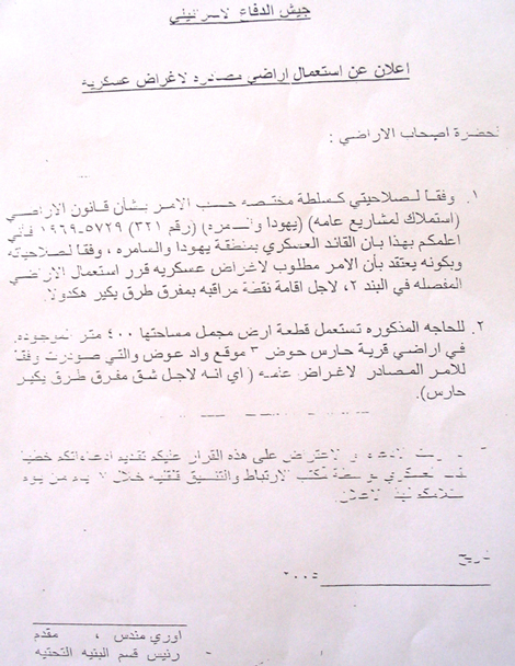
At the beginning of this month, the Israeli army circulated a new military order stipulating the confiscation of 400 square meters in Wadi Awad location, basin number 3, for the establishment of a new military observation point (military watch tower) at the junction leading to Yakir settlement in the north of the village. The order carries the number of 321/5729/1969. See photo 1: copy of the new military order.


Impacts of the new Israeli measures

The following are the expected impacts of the establishment of the new Israeli observation point:

1.     The planned military tower distances only 60 meters from the residential houses which means that the inhabitants of these houses will live under constant fear and unrest.

2.     The expected tower will control the Palestinians movements in and out of the village towards the Trans-Samaria highway and will cut between the western and eastern parts of Salfit Governorate.

3.     It will further limit the movement of Palestinian farmers, shepherds and land owners in the areas surrounding the tower.

It is worth mentioning that the owner of the land, Mr. Husni Ali Shamlawi has presented an objection to the Israeli military committee at Beit Eil, but, yet, to no avail.


Prepared by
The Land Research Center
LRC

Recommended For You

” المواقع الأثرية في محافظة نابلس… ساحة مفتوحة أمام مخططات المصادرة الإسرائيلية “

by arij
August 26, 2025
0
” المواقع الأثرية في محافظة نابلس… ساحة مفتوحة أمام مخططات المصادرة الإسرائيلية “

في العاشر من شهر اب من العام 2025, أصدرت الإدارة المدنية الإسرائيلية كراسة أوامر عسكرية موقعة من قبل رئيس ما يسمى "بالإدارة المدنية الإسرائيلية" في الضفة الغربية المحتلة,...

Read moreDetails

“سيطرة من تحت الأرض”, بواقع 108 أمرا عسكريا, سيطرة اسرائيلية على مياه الفلسطينيين في الضفة الغربية المحتلة

by arij
August 12, 2025
0
بواقع 86 أمرا عسكريا – الأوامر العسكرية الإسرائيلية, الأداة الرئيسية للاحتلال الاسرائيلي للسيطرة على المياه الفلسطينية في الضفة الغربية المحتلة

مقدمة، لطالما شكّلت أزمة المياه إحدى القضايا الأكثر صعوبة في الأراضي الفلسطينية المحتلة، إلا أنها في العقود القليلة الماضية اتخذت منحًنا تصاعديًا خطيرًا، حتى بلغت مستويات غير مسبوقة....

Read moreDetails

تهويد صامت بالأمتار: الطريق إلى بني كيديم خطوة نحو الشرعنة الاستيطانية

by arij
July 16, 2025
0
تهويد صامت بالأمتار: الطريق إلى بني كيديم خطوة نحو الشرعنة الاستيطانية

في الثامن عشر من شهر حزيران من العام 2025، تسلّم أهالي بلدتي سعير والشيوخ الواقعتين شمال شرق محافظة الخليل أمراً عسكرياً إسرائيلياً جديداً يقضي بمصادرة 4.8 دونما من...

Read moreDetails

من غير شرعية إلى واقع مفروض, البؤرة الاستيطانية سدي بوعز في رعاية الاحتلال

by arij
July 15, 2025
0

في الثامن من شهر تموز من العام 2025، سلّمت سلطات الاحتلال الإسرائيلي أمرًا عسكريًا جديدًا يقضي بمصادرة أراضٍ فلسطينية وممتلكات خاصة في بلدة الخضر جنوب غرب محافظة بيت...

Read moreDetails

ملاخي هشالوم: أكثر من مجرد بؤرة استيطانية … مشروع تهويد وتوسّع اسرائيلي

by arij
July 10, 2025
0
ملاخي هشالوم: أكثر من مجرد بؤرة استيطانية … مشروع تهويد وتوسّع اسرائيلي

قامت سلطات الاحتلال الإسرائيلي بتاريخ 7 تموز 2025 بنشر أمر عسكري جديد في الضفة الغربية المحتلة، يحمل عنوان: "أمر بشأن الأملاك الحكومية (يهودا والسامرة) (رقم 59) لسنة 1967"....

Read moreDetails
Next Post
Confiscation of more lands for military uses in Brugin village.

Confiscation of more lands for military uses in Brugin village.

LATEST NEWS

Israeli Breach of the Hebron Agreement through the Establishment of a New Settlement in Area (H1)

Israeli Breach of the Hebron Agreement through the Establishment of a New Settlement in Area (H1)

by arij
August 26, 2025
0

........................................................

خرق إسرائيلي لاتفاقية الخليل بإنشاء مستوطنة جديدة في منطقة (H1)

خرق إسرائيلي لاتفاقية الخليل بإنشاء مستوطنة جديدة في منطقة (H1)

by arij
August 26, 2025
0

........................................................

” المواقع الأثرية في محافظة نابلس… ساحة مفتوحة أمام مخططات المصادرة الإسرائيلية “

” المواقع الأثرية في محافظة نابلس… ساحة مفتوحة أمام مخططات المصادرة الإسرائيلية “

by arij
August 26, 2025
0

........................................................

مشروع (E1): الضربة القاضية لحل الدولتين وإعادة تشكيل الخريطة الجيوسياسية للضفة الغربية

The Government Pushes Forward Plans in E1, Considered a Death Blow to the Two-State Solution

by arij
August 16, 2025
0

........................................................

flag_yellow_lowEU-PfP-Logo

This website has been produced with the assistance of the European Union. The contents of this publication are the sole responsibility of ARIJ & LRC and can in no way be taken to reflect the views of the European Union.

© 2025 Copyright ARIJ . All Rights reserved. .

No Result
View All Result
  • Home
  • Settlements
    • New Israeli Settlements
    • Settlement Expansion
  • Israeli Violations
    • Agriculture
    • Confiscation
    • Demolition
    • Environment
    • Eviction of Palestinians
    • Settlers Attacks
  • Bypass Roads
  • Israeli Plans
  • Segregation
    • Checkpoints
    • Closure
    • Separation Plans
  • Military Orders
  • Reports
    • Daily Report
    • Monthly Report
    • Quarterly Report

© 2025 Copyright ARIJ . All Rights reserved. .