Location and Population
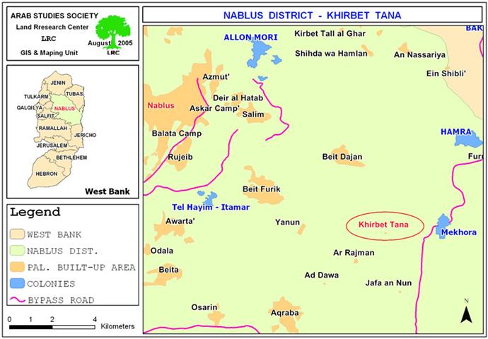
Khirbet Tana is located 7 kilometers to the east Beit Furik town in Nablus in the eastern slopes of the West Bank overlooking the Jordan valley rift. The population of Khirbet Tana is divided into farmers and herd owners as they tend to the Khirba every season especially during winter and spring seasons.
Due to the fact that the Khirba is far from Beit Furik town, residents stay in it to take care of their sheep and to plant their fields with barley and wheat. The number of residents in Tana at the time of the latest demolition was 56 families with total family members of 315. See map of location

Map 1: map of Location of Kherbet Tana- Nablus.
Area
The area of Tana is approximately 2500 dunums of which only 4.8 dunums are for the built up area.
Economic situation
The people of Tana depend on animal husbandry as main income. They own about 7000 head of sheep and goat and 200 cows. Their herds graze in nearby pastures whose total area is estimated at 1500 dunums. They, also use another 1000 dunums for the cultivation of animal fodder such as barley and clover. However, the Khirba severely suffer difficult economic conditions because of its location in the semi dry climate where there is no enough water and no fertile pastures.
Citizens of Tana live a semi nomadic life inside barracks, stone built rooms, caverns, sheds, as well as tents.
Israeli threats put in action
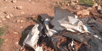
On July 5th, 2005, a large Israeli army force comprised of about 35 jeeps supported by bulldozers stormed Khirbet Tana and started the demolition process of a school, 14 residential barracks, 18 animal barracks and sheds, six animal fodder stores as well as two cisterns under the pretext of un-licensing. The total area of those demolished structures is 2159 square meters (2.159 dunums). During this operation, more than 50 dunums of grazing fields were also burned by the attacking Israeli force, see photo 1 and table 1 below and table 1 below

Photo 1: part of the lands burned by the Israeli army in Kherbit Tana, Photo courtesy of LRC.
Table 1: House, barrack, shed and cistern demolition by name of owner, use and area:
|
No. |
Owner's name |
Use |
Area M2 |
|
1 |
Musa Isa Nasasrah |
One barrack for family use |
36 |
|
|
|
One barrack for animal use |
60 |
|
2 |
Abdul hafiz Hasan Abdul Rahman |
One barrack for family use |
80 |
|
|
|
One barrack for animal use |
75 |
|
|
|
One cavern for storing animal fodder |
Non Available ( NA) |
|
3 |
Firsan Faris Hanani |
One stone built house used as family residence |
60 |
|
|
|
One barrack for animal use |
200 |
|
|
|
One animal fodder store |
NA |
|
4 |
Ra'id Afif Hanani |
One barrack for animal use |
180 |
|
|
|
One cistern |
50 |
|
5 |
Qusai Mustafa Hanani |
One barrack for animal use |
30 |
|
|
|
One animal fodder store |
NA |
|
6 |
Fayez Yusif Hanani |
One barrack for animal use |
150 |
|
|
|
One animal fodder store |
|
|
7 |
Samer Abdul Hafiz Hasan |
One barrack for family use |
40 |
|
|
|
One barrack for animal use |
50 |
|
8 |
Wasif Abu Sa'ud Hanani |
One barrack for family use |
40 |
|
|
|
One barrack for animal use |
120 |
|
9 |
Fursan Musa Isa |
One barrack for family use |
40 |
|
|
|
One barrack for animal use |
70 |
|
10 |
Majid Afif Hanani |
One barrack for family use |
40 |
|
|
|
One barrack for animal use |
180 |
|
|
|
One animal fodder store |
NA |
|
11 |
Arafat Moahmud Nasasrah |
One barrack for animal use |
70 |
|
|
|
One shed for family use |
20 |
|
12 |
Mohammed Faris Hanani |
One shed for family use |
20 |
|
13 |
Mohammed Tawfiq Nasasrah |
One stone built room for family use |
30 |
|
|
|
One barrack for animal use |
60 |
|
|
|
One animal fodder store |
NA |
|
14 |
Abdul Mahdi Nasasrah |
One stone built shed for family use |
20 |
|
|
|
One shed for family use |
50 |
|
15 |
Radi Mahmud Hanani |
One barrack for family use |
50 |
|
|
|
One barrack for animal use |
40 |
|
|
|
One stone built shed for animal use |
40 |
|
|
|
One cistern |
50 |
|
16 |
Zuhdi Nasasrah |
One barrack for animal use |
36 |
|
|
|
One iron built shed for family use |
20 |
|
17 |
Hussein Mustafa Hanani |
One barrack for animal use |
50 |
|
18 |
Mahmud Ahamd Mahmud |
One barrack for family use |
42 |
|
|
|
One barrack for animal use |
100 |
|
Total |
2159 |
||

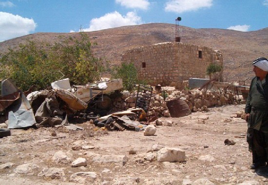
(Photo 2: The ruins of the residential shed of Mr. Fayez Yusif after demolition))
Photo courtesy of LRC
(Photos 3 & 4: ruins of demolished barracks and sheds in Tana)
Photo courtesy of LRC
This operation came as a culmination of ongoing threats of evacuation and dismissal of Khirbet Tana citizens on part of the Israeli occupation forces.
The first wave of these threats started in March, 2004 when 3 Israeli military jeeps reached Khirbet Tana and ordered the residents to leave the area immediately. See photo 5
(Photo 5: Mr. Fawzan Musa Nasasrah is looking at his demolished shed)
)Photo courtesy of LRC
Services in Khirbet Tana
There is an old mosque composed of one old-room of 50 m2 area. It's age is dated back to almost 150 years. See photo 6

Photo 6: The old mosque of Tana, , Photo courtesy of LRC.
In addition, the Kherba used to have an elementary school established in 2001 and consisted of two classrooms of 80 M2 area. The school was demolished in the campaign of July 5th, 2005. Tana is now left with no school. See Photo 7 and Photo 8
Photo 7: Teachers and pupils standing in front of Tana elementary school building before demolition.
Photo 8: some of the furniture of Tana elemnetary school following the demolition
Photo courtesy of LRC
Water Sources
There are three old springs in Tana. A water collection tank was placed to gather water from the upper and lower springs. The middle spring went dry a while ago. Residents of Kherbit Tana use these springs for both human and animal drinking. A number of underground cisterns were dug up for water collection during winter time. Two of these cisterns were demolished during the aforementioned campaign. See photo 9

Photo 9: A general view of Tana dwellings and the school before demolition . : A general view of Tana dwellings and the school before demolition . Photo courtesy of LRC
Prepared by
The Land Research Center
LRC


