• About The Project
  • Palestine in Century
  • Selected Maps
  • Glossary
  • About ARIJ
  • About LRC
  • By Year
    • Case Studies By Year
    • Daily Report By Year
Thursday, June 5, 2025
POICA
No Result
View All Result
  • Home
  • Settlements
    • New Israeli Settlements
    • Settlement Expansion
  • Israeli Violations
    • Agriculture
    • Confiscation
    • Demolition
    • Environment
    • Eviction of Palestinians
    • Settlers Attacks
  • Bypass Roads
  • Israeli Plans
  • Segregation
    • Checkpoints
    • Closure
    • Separation Plans
  • Military Orders
  • Reports
    • Daily Report
    • Monthly Report
    • Quarterly Report
No Result
View All Result
POICA
No Result
View All Result

A Restraining order in Dahiet Al Barid neighborhood

March 9, 2017
in Military Orders
A Restraining order in Dahiet Al Barid neighborhood

On June 22, 2005, the Israeli High Court of Justice issued a temporary restraining order to stop constructions of the Segregation Wall planned in the southern part of Ar Ram Town (Dahiet Al Barid neighborhood), which was supposed to break through the residential houses cutting the neighborhood into separate parts.

The order came in response to the many petitions raised by Ar Ram39;s council, the local inhabitants and the institutions located in Dahiyat Al Barid against the construction of the Segregation Wall in the area.  

Earlier on March 2005, the Israeli Occupation Forces (IOF) had served out residents of Dahiet Al Barid military order number (05/57/T Judea & Samaria 2005) stating the seizure of 26.2 dunums of land, making a way for a new section of the Segregation Wall to be constructed on lands of the area .. Click here for related articles    

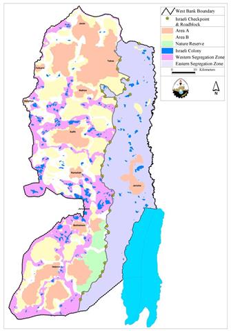
Ar Ram is a Palestinian town, located approximately 7 kilometers northeast of Jerusalem city center.  The built-up area of the town is approximately 3,289 dunums (3.3 km2).  The Wall stretches for six kilometers around Al Ram, encircling the built-up area from almost all sides, controlling the movement of its residents and appropriating large areas of Palestinian lands for the expansion of illegal Israeli settlements. Upon the completion of the wall in the town, Ar Ram and part of Dahiet Al Barid will be cut off from the rest of East Jerusalem and isolated in a tiny ethnic Palestinian ghetto. (See map one). ).

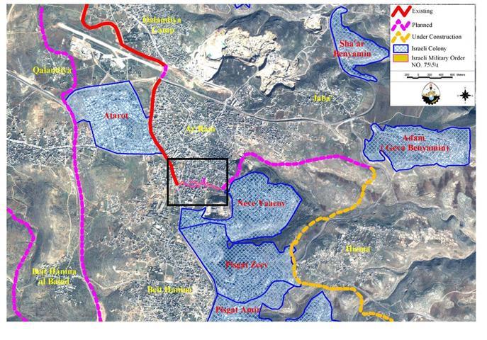
Map 1: Location map, Dahiet Al Barid neighborhood, Ar Ram town and the path of the Segregation Wall.

The Israeli plan to construct the wall in the area intends to isolate an active part of Dahiet Al Barid from the rest of its community, Ar Ram town. The area that is going to become segregated by the Wall includes a number of institutions, they are as shown in map two:

1. Rosary Sister school

2. Rosary Sister Monastry

3. Franciscan Monastry

4. Latin Club

5.  Coptic collage monasteries

6.  Orthodox club

7. World Bank and USAID

8.  British Institution


Map 2: Institutions located at Dahiet Al Barid that will be isolated by the Wall

Status of the Wall in Ar Ram Town:-

The Segregation Wall which is under its final stages of construction, will encircle Ar Ram town, including Dahiet Al Barid neighborhood, from three sides: From the west, separating the area from northwest Jerusalem villages such as Beir Nabala, Al Jib, Al Judeira and Beit Hanina al Tahta where a 6-8 meters high wall is already constructed along the main road from Jerusalem to Qalandyia checkpoint and dividing the area into two parts, (click here for related articles);See Photo 1;

from the south, a section which is under debate, is planned to be constructed and will separate part of Dahiet Al Barid from the rest of the community itself and from Ar Ram town;

from the southeast, the constructed section will separate Al Ram from the nearby illegal settlement of Neve Yaacov; and finally from the north road number 445. Thus, Ar Ram will be confined in a big ghetto where more than 50,000 people will be isolated from the nearby villages and from East Jerusalem. Ar Ram will also lose its southeastern lands, which are the only reserve lands for future extension, and which will be isolated at the other side of the wall (close to the illegal settlement of Neve Yaacov). See photo 2 & Photo 3 &


Conclusion:

The Wall being built in and around Ar Ram town will place it in an isolated Ghetto, adding it to the rest of the Palestinian communities that have also been severely affected by such a blatant violation.

The Segregation wall results in the violation of human rights including the right to freedom of movement, access to holy places, to work, to health, to education, and to an adequate standard of living.  The International Court of Justice (ICJ) decision supports the right to self-determination of the Palestinian people, which they are prevented from exercising by the wall39;s disruption of the territorial integrity and unity of the population.  39;Self-defense39; or 39;state of necessity39; can not be used as justification for violating this right and other international legal principles and therefore Israel must cease construction and all other states must refrain from supporting Israel in building the Wall  39; Article 11 of the ICESCR requires states parties to 39;recognize the right of everyone to an adequate standard of living for himself and his family, including adequate food, clothing and housing, and to the continuous improvement of living conditions39;.

Referances

  • [1] International Covenant on Civil and Political Rights

  • [2] supra note 1, para. 129

  • [3] International Covenant on Economic, Social, and Cultural Rights and the United Nations Convention on the Rights of the Child

  • [4] supra note 1, para. 118

  • [5] supra note 1, para. 122

  • [6] supra note 1, para. 142

  • [7] supra note 1, para. 145

  • [8] supra note 1, para. 146


Prepared by:  
The Applied Research Institute – Jerusalem

Recommended For You

الأراضي الفلسطينية بين الذرائع الأمنية والأطماع الاستيطانية – “الأمن، الآثار، والطبيعة كحجج لاقتلاع الفلسطينيين من أراضيهم”

by arij
April 15, 2025
0

مقدمة شهدت الأراضي الفلسطينية في الضفة الغربية المحتلة على مدار عقود طويلة سياسة ممنهجة من المصادرة الإسرائيلية للأراضي، حيث تبرر سلطات الاحتلال الإسرائيلي هذه السياسة بمجموعة من الذرائع...

Read moreDetails

سلطات الاحتلال الإسرائيلي تخصص ما يزيد عن 16,000 دونما من الأراضي الفلسطينية التي تحيط بالمستوطنات الإسرائيلية لأغراض الرعي

by arij
February 12, 2025
0
سلطات الاحتلال الإسرائيلي تخصص ما يزيد عن 16,000 دونما من الأراضي الفلسطينية التي تحيط بالمستوطنات الإسرائيلية لأغراض الرعي

  أصدرت سلطات الاحتلال الإسرائيلي في العاشر من شهر شباط من العام 2025 ستة أوامر عسكرية جديدة تقضي"بإعلان عن نية المسؤول عن الأملاك الحكومية وأملاك الغائبين على المصادقة...

Read moreDetails

Sheep Pens in Bardala Village Falls to a systematic Attack of the Israeli Army, Aiming to Displace the Community

by arij
January 30, 2025
0
اخطارات اسرائيلية بوقف العمل في قرية بردلة

The Israeli Settlement Council Organization stormed the village of Bardala, northeast of Tubas, targeting a sheep pen owned by Mr. Louay Abu Rushdi. The escorting occupation Army issued...

Read moreDetails

اخطارات اسرائيلية بوقف العمل في قرية بردلة

by arij
January 30, 2025
0
اخطارات اسرائيلية بوقف العمل في قرية بردلة

  الموقع: بردلة -الأغوار الشمالية / محافظة طوباس الجهة المعتدية: المجلس الأعلى للتخطيط /تنظيم مجلس المستوطنات الجهة المتضررة: السيد لؤي ابو رشدي الانتهاك: وقف عمل لحظيرة أغنام تفاصيل...

Read moreDetails

إخطارات بهدم بركسات سكنية وزراعية في تجمع عاطوف

by arij
January 23, 2025
0
Demolition Notices for Residential and Agricultural Structures in the Atouf Community

  الانتهاك: إخطارات بهدم مسكن وحظائر اغنام الموقع: الرأس الاحمر- عاطوف / محافظة طوباس الجهة المعتدية: تنظيم مجلس المستوطنات الجهة المتضررة: السيد ثائر حسين تفاصيل الانتهاك أقدمت قوات...

Read moreDetails
Next Post
The Plot of the Eastern Segregation Wall

The Plot of the Eastern Segregation Wall

LATEST NEWS

77 عام  على النكبة الفلسطينية: حاضر مستمر لا تاريخ منتهي

77 عام  على النكبة الفلسطينية: حاضر مستمر لا تاريخ منتهي

by arij
June 2, 2025
0

........................................................

Expansion of Gilo Settlement: A Strategic Plan to Isolate Bethlehem and Undermine Palestinian Rights

Expansion of Gilo Settlement: A Strategic Plan to Isolate Bethlehem and Undermine Palestinian Rights

by arij
May 12, 2025
0

........................................................

الأراضي الفلسطينية بين الذرائع الأمنية والأطماع الاستيطانية – “الأمن، الآثار، والطبيعة كحجج لاقتلاع الفلسطينيين من أراضيهم”

by arij
April 15, 2025
0

........................................................

الطرق الالتفافية الاسرائيلية وأثرها على البيئة الفلسطينية

انتهاك للطبيعة والهوية في الأراضي الفلسطينية المحتلة

by arij
March 17, 2025
0

........................................................

flag_yellow_lowEU-PfP-Logo

This website has been produced with the assistance of the European Union. The contents of this publication are the sole responsibility of ARIJ & LRC and can in no way be taken to reflect the views of the European Union.

© 2025 Copyright ARIJ . All Rights reserved. .

No Result
View All Result
  • Home
  • Settlements
    • New Israeli Settlements
    • Settlement Expansion
  • Israeli Violations
    • Agriculture
    • Confiscation
    • Demolition
    • Environment
    • Eviction of Palestinians
    • Settlers Attacks
  • Bypass Roads
  • Israeli Plans
  • Segregation
    • Checkpoints
    • Closure
    • Separation Plans
  • Military Orders
  • Reports
    • Daily Report
    • Monthly Report
    • Quarterly Report

© 2025 Copyright ARIJ . All Rights reserved. .