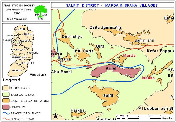
On June 1st, 2005, the Israeli bulldozers resumed constructions of the Segregation Wall in Marda village (located north of Salfit city). The resumption of work came after a halt that lasted for several months following the decision taken by the Israeli high court in response to objections presented by affected Palestinian farmers and land owners. The Wall plan in this village aims at annexing the second largest settlement in the West Bank the settlement of Ariel into Israeli proper at the expanse of Palestinians.
The village of Marda
The village of Marda is located 9 km northeast Salfit city. It houses a total population of 2200 inhabitants and occupies a total land area of 9020 dunums, out of which 500 dunums comprise built up area. Of the aforementioned village total, More than 3600 dunums (33% of the villages total lands ) were seized for the construction and the expansion of Ariel settlement.

Map 1: Location Map of Marda Village
Brief introduction to Ariel Settlement
Ariel Settlement was established in 1978 following the Camp David Accords between Egypt and Israel..The settlement, gradually expanded over the years from the east and south on lands originally confiscated from Marda, Kafl Haris and Iskaka all located in Salfit Governorate until it became the second largest Jewish settlement in the West Bank (the capital of Samaria in Jewish term) along with a large industrial zone, tourist hotel and a university. The settlement is located 20 km to the east of the Armistice Line, inside the West Bank proper and is linked to Israel by the Trans Samaria Highway. Currently, it has a total area of 29000 dunums (three folds bigger than Marda village) and houses a population of 18000 settlers.
Marda and the Wall
Constructions of the Segregation Wall started in Marda village late in 2004. Shortly after, it was halted following a series of protests and objections by the affected Palestinian land owners and farmers who submitted all related land ownership documents to the Israeli high court in an attempt to prove their ownership of the lands and stop wall constructions in the village. The court suspended all works until further discussion and reviewing.
Nevertheless, in March 2005, the commander of the Israeli army in the West Bank, Ya'ir Neve, signed a new military order stating the confiscation of 197 dunums of Marda village lands for Wall construction.


Photo 1,2 Copies of the military order against Marda land , Copies of the military order against Marda land

( Map 2: topographic map attached to the military order))
The aforementioned Israeli military order contradicts the latest version of the amended Wall map which was issued by the 'Israeli Ministry of Defense' on February 20th, 2005, claiming that the Wall works had been stopped in this section (about 129 km long) for further discussion and debate.

( Map 3: topographic map of the newly confiscated strip
of land around Ariel settlement))

Photo 4: (an aerial photo showing Marda besieged between
Ariel settlement and Samaria highway))
Losses incurred by Wall construction in Marda
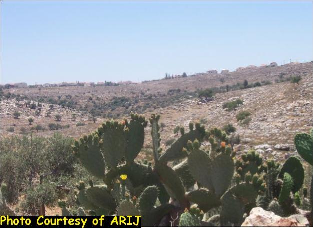
At least 1000 dunums of agricultural and arid lands of Marda village are expected to be confiscated or separated behind the Wall. In addition, about 1000 long-lived olive trees which are considered the primary source of living for the affected Palestinian families have been either destroyed or uprooted in addition to 800 trees of similar types will be separated behind the Wall. This number is likely to increase as work goes on from one place to another south of Marda village, which, eventually, will be totally besieged between the settlement of Ariel in the south and the Trans Samaria highway in the north.
Animal breeders will also be affected by the loss of grazing areas and water resources as vast areas of pastures and several cisterns will be separated behind the Wall and access to them is denied.
A profile of Israeli violations against the village
Ever since the occupation of 1967, the village of Marda has been under the successive series of Israeli violations targeting humans and lands as followed:
1. In 1978, the village was exposed to a colonial onslaught during which 400 dunums of its lands were forcibly seized to make a room for the establishment of Ariel settlement. In successive years, a total of 3660 dunums from the villages lands were seized for the expansion of the aforementioned settlement. Moreover, hundreds of additional dunums located in the vicinity of the settlement were spoiled and contaminated by the deliberate pumping of wastewater coming out of the settlement into the villages lands creating an ecological disaster for both the lands and the people;
2. The very often attacks by the Israeli army on the village with sound bombs, gun fire and tear gas bombs with the aim of frightening its inhabitants;
3. Denying Palestinian farmers access to their agricultural lands, especially during olive picking seasons;
4. The release of dozens of wild pigs in the lands of the village with the aim of destroying agriculture and frightening farmers;
5. The confiscation and devastation of about 120 dunums of land for the construction of the Trans Samaria Highway number 1 in 1980. This confiscation process led to the uprooting of at least 240 olive trees;
6. During the current Intifada, 110 dunums of fertile agricultural land to the north of the village of Marda were seized for the construction of the Trans Samaria Highway number 2, leading to the uprooting of 230 olive trees and the announcement of the area as a closed military zone;
7. On July 27th, 2004, 4 dunums of the village lands were bulldozed under the pretext that stones were thrown from the area at Israeli cars passing the Trans Samaria Highway;
On August 17th, 2004, Israeli settlers burned 140 olive trees planted in 7 dunums of lands located to the east of the village. A complaint was presented by Palestinian land owners to the DCO against this action but no response has yet been given.

( Photo 5: burned olive trees to the right side of Trans Samaria Highway)
( Photo courtesy of LRC)
Summation of losses
According to LRC field work, a total of 44% of Marda village lands are already seized or will be seized or separated once the Wall is completed. These lands are divided as followed:
1. 3660 dunums for Ariel settlements;
2. 1000 dunums for Wall constructions;
3. 120 dunums for constructing Samaria High Way # 1;
4.110 dunums for constructing Samaria Highway # 2.
5. A total of 2410 olive trees were either uprooted or separated as followed:
-
-
1000 olive trees have been uprooted and 800 others will be separated by the construction of the Segregation Wall;
-
240 olive trees uprooted for constructing the Samaria Highway #1;
-
230 olive trees were uprooted for constructing the Samaria highway #2;
-
140 olive trees were burned at the hands of Israeli settlers.
-
Prepared by
The Land Research Center
LRC