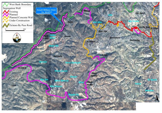
The Israeli Defense Army has just released a new military order # 86/05/T under which five Palestinian villages (Walajeh, Battir, Husan, Nahalin, Wad-Fukin and Al Jab'a) will fall into the Israeli Segregation Wall trap; in addition to cutting off these villages from significant 4500 dunums of agricultural lands that constitute to many of the residents a main source of income.
The Israeli military order; signed and released by the high commander of the Israeli Army on April 21, was only available to Palestinian landowners after two weeks and included a description of the confiscation order along with the targeted villages' names, parcel numbers and area confiscated at each location.
According to the military order, the targeted area covers in length 10,560 meters (6.6 miles) and 130 meters width; bringing the total area set to erect the Segregation Wall to a total of 757 Dunums. However, that is not entirely true as calculations of targeted area conducted by the GIS (Geographical Information System) department at the Applied Research Institute-Jerusalem (ARIJ) which shows that the actual size of the targeted area as described in the military order stands at 970 Dunums; a miscalculation that habitually occurs with Israeli military orders. See Map of wall plan of Bethlehem western rural areas. .
Analysis of military Order:-
The Israeli army claimed that residents in the targeted villages would have free access to their lands as soon as they get permits from the Israeli civil administration to enter their agricultural fields. Farmers' access to the lands beyond the Segregation Wall (upon completion) will be through 12 Israeli controlled iron gates. However, what the Israelis will not say is that they will only issue permits to farmers who are able to prove landownership through a credited Israeli organization (most likely to be the civil administration) and only the owner/s whose name/s listed in the ownership deeds (usually the eldest of the families) will receive permits. Furthermore, the Israeli civil administration will only issue permits to those who receive a clean bill of security clearance and on seasonal basis, when the owners will find a hard time to manage the fields on their own especially that the permits do not include additional labor or equipments.
The new military order will put the residents of the three villages Husan, Battir, Al Walajeh in a ghetto where their only connection with Bethlehem district (main service provider) is a single exit, an underground tunnel that connects between the three villages and Al-Khader village across the bypass road #60 under which the tunnel goes.
Residents of Wadi-Fukin and Nahalin will however have to go through a tunnel of their own under bypass road #375 to get to Husan village before they go under the second tunnel from Battier to Bethlehem district. Al Jab'a village will be left outside the Ghetto of Bethlehem Western Rural villages, but will be included within the Hebron Ghetto; thus cutting it off from Bethlehem Governorate.
In addition, the Israelis did not detail whether they will require Palestinian citizen of the trapped villages to acquire permits to enter and exist their home villages like other Palestinian localities entrapped by the Segregation Wall north of the West Bank. However, it is most likely that the Israeli Army will substantiate residency of the targeted villages with ID cards verification, which exclude non-residents to enter the villages.
Conclusion:-
The Western rural villages of Bethlehem district has suffered massive loss since the Israeli occupation of the West Bank in 1967, considerable agricultural land areas were confiscated for settlements and bypass roads construction and now the Segregation Wall. All and all, 29% (13000 Dunums) of total area (45,000 Dunums) of Bethlehem western rural villages will be slated upon the completion of the Segregation Wall.
Prepared by:
The Applied Research Institute – Jerusalem


