• About The Project
  • Palestine in Century
  • Selected Maps
  • Glossary
  • About ARIJ
  • About LRC
  • By Year
    • Case Studies By Year
    • Daily Report By Year
Monday, June 2, 2025
POICA
No Result
View All Result
  • Home
  • Settlements
    • New Israeli Settlements
    • Settlement Expansion
  • Israeli Violations
    • Agriculture
    • Confiscation
    • Demolition
    • Environment
    • Eviction of Palestinians
    • Settlers Attacks
  • Bypass Roads
  • Israeli Plans
  • Segregation
    • Checkpoints
    • Closure
    • Separation Plans
  • Military Orders
  • Reports
    • Daily Report
    • Monthly Report
    • Quarterly Report
No Result
View All Result
POICA
No Result
View All Result

The impacts of the Segregation Wall on Khirbet Jubara, Tulkarem

March 9, 2017
in Segregation
The impacts of the Segregation Wall on Khirbet Jubara, Tulkarem


Location and population

Khirebt Jubara is located 5 km to the south of Tulkarem city near the Green Line. It is mostly an agricultural village, depending on cultivation and chicken rearing for commercial purposes where 90% of the village's income comes from those two sectors.

Village area 

The total village built up area is 171 dunums. The rest of the village area is cultivated with citrus and olive trees, as well as cereals and irrigated vegetables.


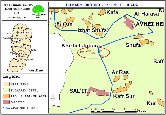
(Map 1- Location of Khirebt Jubara))

Israeli violations against the village

The village has gone under many Israeli violations throughout the occupation, the latest of which was the construction of the Segregation Wall which led to the confiscation and separation of hundreds of dunums of agricultural lands.  Now, the Segregation Wall surrounds the village from all directions leaving only two passage ways through:

  • Al Kafriyat checkpoint in the north of the village: (The only access point into and out of Khebit Jubara for residents with valid permits.)

  • Gate number 22 in the south of the village which was installed in early August 2003 and is only opened to students and rarely for village's residents.

The latest is opened twice a day (from 7:00 am to 7:30 am and from 12:00 pm to 12:30 pm) to allow farmers access their lands segregated behind the Wall. School students, also, use this gate on their way to and from the nearby village of Ar Ras.


(Photo 1 and Photo 2– Khirbet Jubara- Tulkarem- Northern entrance to Khirbet Jubara protected by an army tower
(Photos courtesy of LRC)
 

The Wall path around the village is 70 meters wide and 5 km long ( about 350 dunums have been seized for this purpose) apart from the lands segregated behind the Wall and are estimated at 4000 dunums. ( This number includes the neighboring villages such as Ar Ras, Izbat Shufa and Sal'it. 

Wall impacts  

1- At the economic level

The Wall has led to the actual devastation of about 350 dunums of agricultural lands, the uprooting of hundreds of fruitful trees of various types and the segregation of hundreds of additional dunums. Many horticulture irrigation systems were also destroyed during the construction of the Wall.

The transfer of agricultural commodities out of the village was hampered by the Israeli travel restrictions, stipulating the acquisition of special permits from the Israeli military for all commercial trucks involved in this process. In most cases, permits were denied and commodities spoiled, either in loaded trucks or on the ground. These restrictions and complications have discouraged many farmers from carrying on with their farming and, therefore, raised the percentages of unemployment and poverty in the village to un- precedent levels.  

Meanwhile, the Israeli occupation forces have put many obstacles in the face of governmental and non-governmental institutions offering humanitarian and developmental services to the village by asking them to obtain permits from the Israeli military.

2- At the social level

The construction of the Wall has separated the village from its environs.  Social links between the village citizens and the out side world were reduced to the minimum. This has been due to the entry-prohibition policy adopted by the Israeli military since they don't allow anyone to get out of the village without having valid passing permits.

3- At the educational level

Khirbet Jubarais out of Educational services; therefore students have to leave their homes quite early in the morning and gather at gate No. 22. This gate serves as the only exit leading south to the neighboring village of Ar Ras where schools are situated. Students have to wait there until the army patrol comes and opens the gate.  

In fact, the opening of the gate is totally dependent on the whims of individual soldiers, who have no respect for school time or schedule, a situation that results in students waiting long hours under rain or heat, and loosing a number of  school classes every day. This miserable treatment resulted in psychological effects on those students and on the educational achievement.


( Photo 3 & Photo 4 -Khirbet Jubara- Tulkarem: The southern entrance- Gate No. 22 where pupils and farmers have to wait long hours before reaching destination) 
(Photos courtesy of LRC)

In many times, even, the Israeli forces refuse to open the gate all day denying the village students the right to education as human beings. In related envelopment, UNESCO has erected two umbrellas by the gate to protect school pupils from rain and heat.

( Photo 5– Khirbet Jubara- Tulkarem: one of the umbrellas provided by UNESCO for the use of school pupils) 
(Photo courtesy of LRC)

New military decrees

It is worth mentioning that on 28.12.2004, the Israeli army issued new land confiscation orders claiming the amendment of the Wall path around the village with the aim of bringing it out of the Wall circle. This amendment, however, will lead to the confiscation and separation of more village lands, contrary to the Palestinian demands of reducing the already seized village lands. 


Prepared by
The Land Research Center
LRC

Recommended For You

سلطات الاحتلال الإسرائيلي تفرض واقعا جيوسياسيا جديدا في منطقة شمال قطاع غزة المحتل

by arij
March 13, 2024
0
سلطات الاحتلال الإسرائيلي تفرض واقعا جيوسياسيا جديدا في منطقة شمال قطاع غزة المحتل

  أظهرت صور الأقمار الصناعية الصادرة عن برنامج مراقبة الأرض التابع للاتحاد الأوروبي (كوبرنيكوس) لقطاع غزة المحتل في العاشر من شهر اذار من العام 2024، ان سلطات الاحتلال...

Read moreDetails

الحرب على قطاع غزة وتأثيرها على محافظة الخليل جنوب الضفة الغربية

by arij
November 30, 2023
0

  تقع محافظة الخليل في الجزء الجنوبي من الضفة الغربية المحتلة، إلى الجنوب من مدينة القدس، وعلى بعد حوالي 36 كم منها. يحدها من الشمال محافظة بيت لحم،...

Read moreDetails

تطبيق سياسة الفصل العنصري على استخدام الطرق الرئيسية في الضفة الغربية وتقيد حركة وتنقل المواطنين الفلسطينيين

by arij
November 22, 2023
0
معاناة شجرة الزيتون الفلسطينية بسبب الاحتلال والاستيطان في العام 2023

  بناء على تقديرات مراقبين دوليين يبلغ عدد الحواجز الإسرائيلية في الضفة الغربية أكثر من 567 حاجز إسرائيلي متعددة الاشكال منها 77 حاجزًا رئيسيًا وجزئي تتحكم في حركة...

Read moreDetails

The Instigation of Apartheid Roads Era: Israel blocks Palestinian movement inside West Bank Governorates

by arij
November 22, 2023
0

  According to international observers, Israel constrains the West Bank territory with 567 various types of obstacles; 77 of which are main checkpoints and partial checkpoints that control...

Read moreDetails

Between “Ben Gavir” and Netanyahu Not Oblivious but Vindictive, The reality of Israeli Apartheid Stands in the occupied Palestinian territory

by arij
September 13, 2023
0
Between “Ben Gavir” and Netanyahu Not Oblivious but Vindictive, The reality of Israeli Apartheid Stands in the occupied Palestinian territory

  In the wake of the overwhelming Israeli settlers and the Israeli occupation government increasing their wave of attacks and assaults on the Palestinian people (more than 700...

Read moreDetails
Next Post
Israeli Occupying Forces flout High Court Ruling

Israeli Occupying Forces flout High Court Ruling

LATEST NEWS

77 عام  على النكبة الفلسطينية: حاضر مستمر لا تاريخ منتهي

77 عام  على النكبة الفلسطينية: حاضر مستمر لا تاريخ منتهي

by arij
June 2, 2025
0

........................................................

Expansion of Gilo Settlement: A Strategic Plan to Isolate Bethlehem and Undermine Palestinian Rights

Expansion of Gilo Settlement: A Strategic Plan to Isolate Bethlehem and Undermine Palestinian Rights

by arij
May 12, 2025
0

........................................................

الأراضي الفلسطينية بين الذرائع الأمنية والأطماع الاستيطانية – “الأمن، الآثار، والطبيعة كحجج لاقتلاع الفلسطينيين من أراضيهم”

by arij
April 15, 2025
0

........................................................

الطرق الالتفافية الاسرائيلية وأثرها على البيئة الفلسطينية

انتهاك للطبيعة والهوية في الأراضي الفلسطينية المحتلة

by arij
March 17, 2025
0

........................................................

flag_yellow_lowEU-PfP-Logo

This website has been produced with the assistance of the European Union. The contents of this publication are the sole responsibility of ARIJ & LRC and can in no way be taken to reflect the views of the European Union.

© 2025 Copyright ARIJ . All Rights reserved. .

No Result
View All Result
  • Home
  • Settlements
    • New Israeli Settlements
    • Settlement Expansion
  • Israeli Violations
    • Agriculture
    • Confiscation
    • Demolition
    • Environment
    • Eviction of Palestinians
    • Settlers Attacks
  • Bypass Roads
  • Israeli Plans
  • Segregation
    • Checkpoints
    • Closure
    • Separation Plans
  • Military Orders
  • Reports
    • Daily Report
    • Monthly Report
    • Quarterly Report

© 2025 Copyright ARIJ . All Rights reserved. .