• About The Project
  • Palestine in Century
  • Selected Maps
  • Glossary
  • About ARIJ
  • About LRC
  • By Year
    • Case Studies By Year
    • Daily Report By Year
Monday, October 13, 2025
POICA
No Result
View All Result
  • Home
  • Settlements
    • New Israeli Settlements
    • Settlement Expansion
  • Israeli Violations
    • Agriculture
    • Confiscation
    • Demolition
    • Environment
    • Eviction of Palestinians
    • Settlers Attacks
  • Bypass Roads
  • Israeli Plans
  • Segregation
    • Checkpoints
    • Closure
    • Separation Plans
  • Military Orders
  • Reports
    • Daily Report
    • Monthly Report
    • Quarterly Report
No Result
View All Result
POICA
No Result
View All Result

Stages of the Segregation Wall construction in Hebron Governorate !!!

March 9, 2017
in Segregation
Stages of the Segregation Wall construction in Hebron Governorate !!!


The Israeli occupation authorities continue the construction processes of the Apartheid Segregation Wall in Hebron district despite the Palestinian on going Palestinian protests. 

The following are the actual construction stages of the Wall:

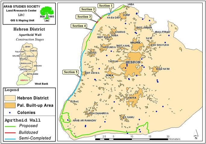
1- The first section: it has the distance of 2 km starting from the land of Jaba'a village in the north western corner of Hebron district and going through the lands of Surif town and Khirbet Adeir. The path of the Wall in the first section travels at a depth ranging between 0 to 200 meters to the east of the Artimistice Line (Green Line) inside the lands of the West Bank. The road has been opened at a width of 30 – 50 meters. Base course has been provided. Cement basis for the erection of the fence has been fixed. Israeli machineries were seen working in the site. Almost 300 dunums were seized in this section. (See section 1 on the attached map). ).

( Map 1))


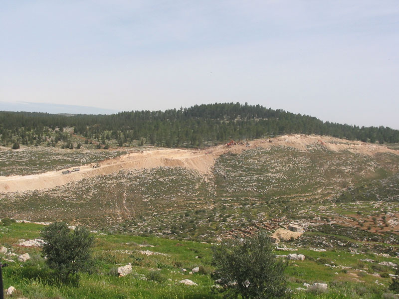
( Photo 1- Israeli machinery preparing the path of the Wall opposite to Surif and Ed Deir villages.
(
(
photo courtesy of LRC ) )

2- The second section: it is located within the lands of Khirbet Adeir. This section is about 200 meters long. It travels 100 meters to the east of the Artimistice Line (Green Line). The road has been bulldozed at a width of 30 meters, but no further works were done.  ( see section 2 on the attached map) Works in this section were halted last October following objections by the Land owners.  No machinery was seen at the site. Almost 30 dunums have been seized in this section.) Works in this section were halted last October following objections by the Land owners.  No machinery was seen at the site.

3- The third section: It is located within the lands of Khirbet Adeir and the village of Kharas. It travels 100 meters to the east of the Artimistice Line (Green Line) at a distance of 300 meters. The road has been bulldozed at a width of 30 meters. Works were halted here due to petitions objections presented by Palestinian last October. No machinery was seen at the site. ( see section 3 on the attached map). Targeted lands are cultivated with fruitful olive trees and located in a very fertile plain. About 40 dunums have already been seized in this section.). Targeted lands are cultivated with fruitful olive trees and located in a very fertile plain.

4- The fourth section: it is located in the lands of Beit Ula and Nuba villages. It travels between 100 to 500 meters to the east of the Artimistice Line (Green Line) at a distance of 2200 meters. The road has been opened at a width of 30 – 50 meters. Base course has also been provided. Cement basis for the erection of the fence has been fixed. Israeli machinery was seen working at the site.  ( see section 4 on the attached map). About 700 dunums have been seized in this section.).

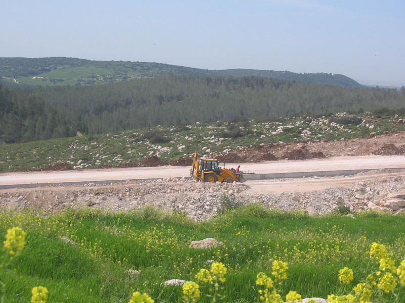
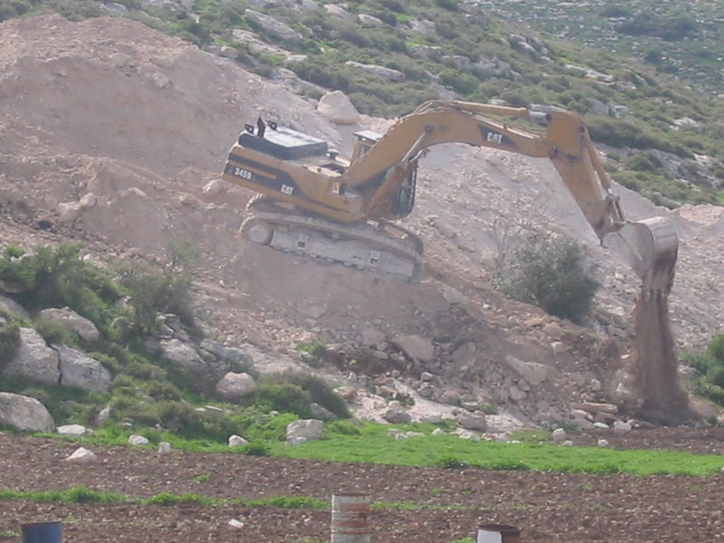
( Photo 2- Israeli machinery working in the path of the road in Khirbet Attus affiliated to Beit Ula village west of Hebron- – Photo courtesy of LRC) )

 5- The fifth section: It starts from Edna town, all the way to Al Burj village. It travels at a distance of about 15 km and goes between 100 to 500 meters deep inside the lands of the West Bank.  The road has been opened at a width of 30 – 50 meters. Base course have also been provided. Cement basis for the erection of the fence has been fixed. Israeli machinery was seen working at the site (see section 5 on the attached map). The following are the Palestinian villages whose lands are affected by this section (Section 5) of the Wall (respectively from north to south):  Edna, Deir Samit, Beit Awwa, Sikka, Al Majd, Deir al Asal al Tihta, Deir al Asal al Fouqa, Beit Arrush, Beit Mirsim and Al Burj. About 4500 dunums have been seized in this section.). The following are the Palestinian villages whose lands are affected by this section (Section 5) of the Wall (respectively from north to south):  Edna, Deir Samit, Beit Awwa, Sikka, Al Majd, Deir al Asal al Tihta, Deir al Asal al Fouqa, Beit Arrush, Beit Mirsim and Al Burj.

Photo 3- A Caterpillar preparing the road to the west of Edna town.

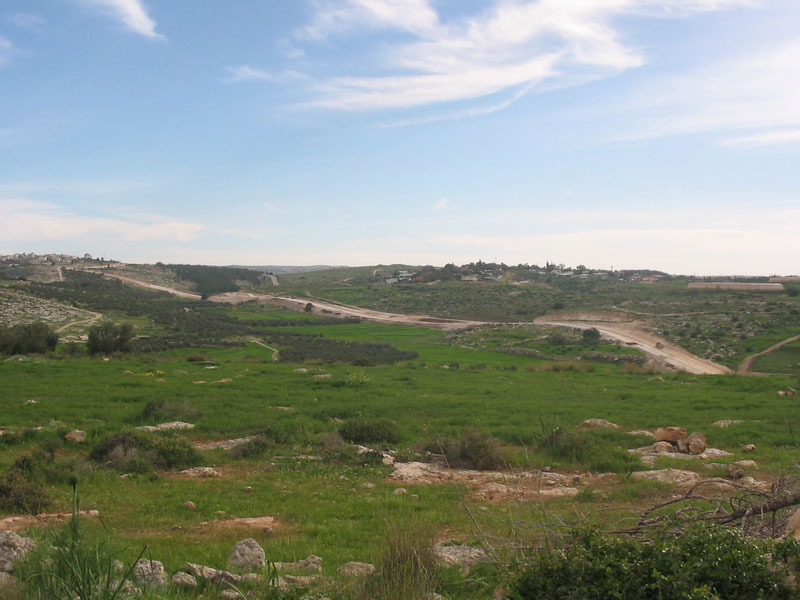
Photo 4- A section of already constructed Wall road in Deir Samit Lands..

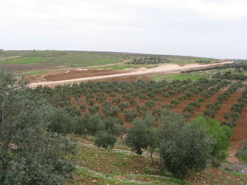
Photo 5- A section of the Wall road in Sikka village lands.

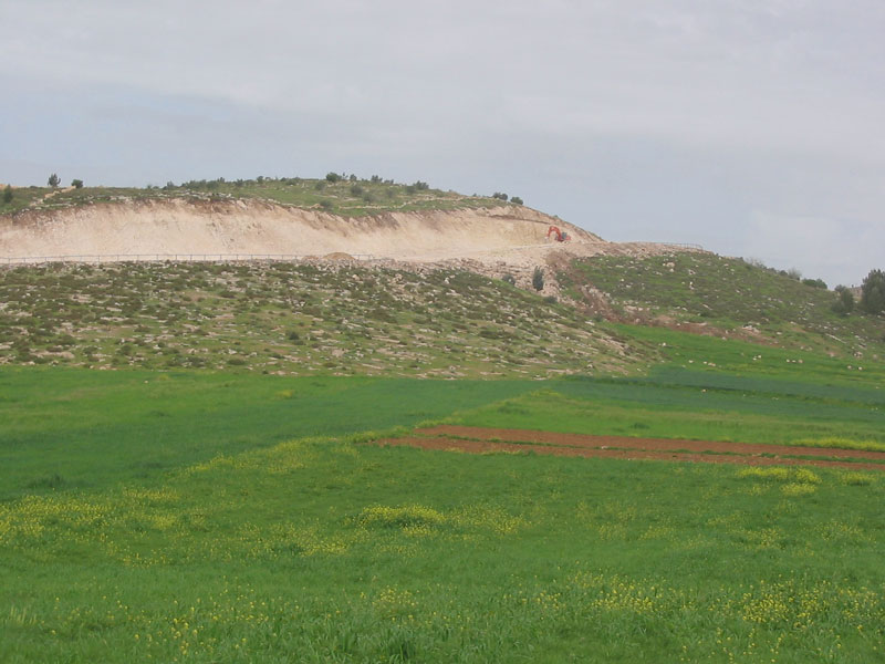
Photo 6- Cutting through hills in Al Majid Lands

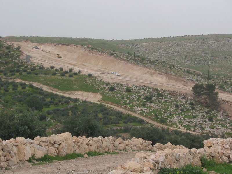
photo 7- Cutting through hills in Beit Arrush

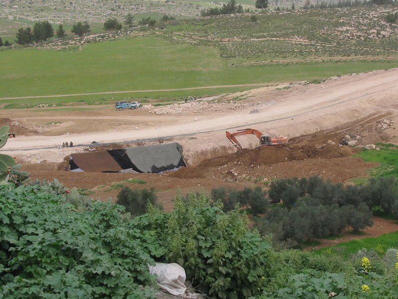
photo 8- Constructing water drainage systems  under Wall paths in Al Burj Lands

( Photo courtesy of LRC)

 The total area of land actually seized so far is 5570.

New military orders

On March 2nd, 2005, the Israeli occupation authorities announced the seizure of 10104 dunums of lands of Edha iriya, Yatta and Es Samu villages for the construction for the Segregation Wall.  The recent land seizure was mentioned in a military decree signed by general Ya'ir Nave, commander of the Israeli armed forced in the West Bank., carrying the number of T/04/05 (see attached copy of military decree).

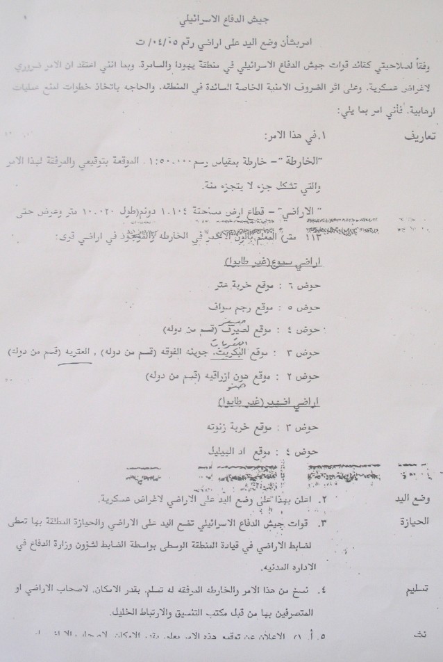
( Photo 9- A copy of the latest military order No. T/04/05))

The aforementioned military decree came in contradictory with the latest amendment of the path of the Wall in the West Bank taken by the Israeli government on February 20th, 2005. 


Prepared by
The Land Research Center
LRC

Recommended For You

عقاب جماعي يومي: الفلسطينيون تحت هيمنة الحواجز العسكرية

by arij
September 24, 2025
0
عقاب جماعي يومي: الفلسطينيون تحت هيمنة الحواجز العسكرية

تشهد الضفة الغربية المحتلة واقعًا خانقًا نتيجة السياسات الإسرائيلية المتمثلة بفرض المزيد من الحواجز العسكرية اليومية والإغلاقات، والتي باتت أداة منهجية للسيطرة والتحكم بحياة الفلسطينيين اليومية، وليست مجرد...

Read moreDetails

العدالة المؤجلة ورأي بلا تنفيذ: من قرار المحكمة إلى واقع الضم

by arij
July 9, 2025
0
العدالة المؤجلة ورأي بلا تنفيذ: من قرار المحكمة إلى واقع الضم

مقدمة في التاسع من تموز 2004، أصدرت محكمة العدل الدولية، وهي الجهاز القضائي الرئيسي للأمم المتحدة، رأيا استشاريا تاريخيا اعتبرت فيه بناء اسرائيل لجدار الفصل في الاراضي الفلسطينية...

Read moreDetails

سلطات الاحتلال الإسرائيلي تفرض واقعا جيوسياسيا جديدا في منطقة شمال قطاع غزة المحتل

by arij
March 13, 2024
0
سلطات الاحتلال الإسرائيلي تفرض واقعا جيوسياسيا جديدا في منطقة شمال قطاع غزة المحتل

  أظهرت صور الأقمار الصناعية الصادرة عن برنامج مراقبة الأرض التابع للاتحاد الأوروبي (كوبرنيكوس) لقطاع غزة المحتل في العاشر من شهر اذار من العام 2024، ان سلطات الاحتلال...

Read moreDetails

الحرب على قطاع غزة وتأثيرها على محافظة الخليل جنوب الضفة الغربية

by arij
November 30, 2023
0

  تقع محافظة الخليل في الجزء الجنوبي من الضفة الغربية المحتلة، إلى الجنوب من مدينة القدس، وعلى بعد حوالي 36 كم منها. يحدها من الشمال محافظة بيت لحم،...

Read moreDetails

تطبيق سياسة الفصل العنصري على استخدام الطرق الرئيسية في الضفة الغربية وتقيد حركة وتنقل المواطنين الفلسطينيين

by arij
November 22, 2023
0
معاناة شجرة الزيتون الفلسطينية بسبب الاحتلال والاستيطان في العام 2023

  بناء على تقديرات مراقبين دوليين يبلغ عدد الحواجز الإسرائيلية في الضفة الغربية أكثر من 567 حاجز إسرائيلي متعددة الاشكال منها 77 حاجزًا رئيسيًا وجزئي تتحكم في حركة...

Read moreDetails
Next Post

Hizma: A Palestinian Village between the Wall and the Settlements

LATEST NEWS

محافظة أريحا على خريطة المصادرة الإسرائيلية- إسرائيل تسعى للاستحواذ على أكثر من 7000 دونم في منطقة النبي موسى

محافظة أريحا على خريطة المصادرة الإسرائيلية- إسرائيل تسعى للاستحواذ على أكثر من 7000 دونم في منطقة النبي موسى

by arij
October 13, 2025
0

........................................................

ما يزيد عن 1900 دونما من الأراضي الفلسطينية في بيت لحم مهددة بالعزل لصالح مستوطنة افراتا

ما يزيد عن 1900 دونما من الأراضي الفلسطينية في بيت لحم مهددة بالعزل لصالح مستوطنة افراتا

by arij
October 8, 2025
0

........................................................

Annexation of the Jordan Valley: Implications for the Two-State Solution and Regional Stability

Annexation of the Jordan Valley: Implications for the Two-State Solution and Regional Stability

by arij
September 29, 2025
0

........................................................

Isolation of Three Villages Northwest of Jerusalem: Silent Annexation Creeps toward the Capital

عزل ثلاث قرى فلسطينية شمال غرب مدينة القدس: الضم الاسرائيلي الصامت يزحف نحو محيط العاصمة

by arij
September 24, 2025
0

........................................................

flag_yellow_lowEU-PfP-Logo

This website and its content were initiated in 1993 by the Applied Research Institute – Jerusalem (ARIJ) and the Land Research Center (LRC) with the support from the European Union up until 2023. Since then, the Applied Research Institute – Jerusalem (ARIJ) has taken over the continued development and maintenance of the website. The views expressed remain solely those of ARIJ) and do not necessarily reflect those of the European Union.

© 2025 Copyright ARIJ . All Rights reserved. .

No Result
View All Result
  • Home
  • Settlements
    • New Israeli Settlements
    • Settlement Expansion
  • Israeli Violations
    • Agriculture
    • Confiscation
    • Demolition
    • Environment
    • Eviction of Palestinians
    • Settlers Attacks
  • Bypass Roads
  • Israeli Plans
  • Segregation
    • Checkpoints
    • Closure
    • Separation Plans
  • Military Orders
  • Reports
    • Daily Report
    • Monthly Report
    • Quarterly Report

© 2025 Copyright ARIJ . All Rights reserved. .