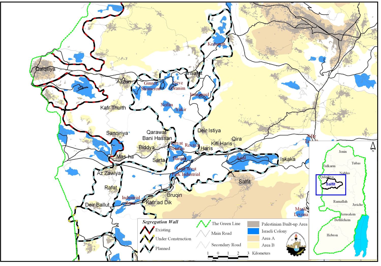
Salfit governorate lies in the northwestern part of the West Bank. It is surrounded by Qalqiliya Governorate from the north, Ramallah Governorate from the south, Nablus Governorate from the east and the Green line from the west. Salfit governorate has a total area of 202,066 dunums. Within the Governorate boundaries there are 22 Israeli settlements that eat up 18,620 dunums; 9.21 % of the governorate area. Salfit city is the major urban center in the governorate with a population of about 10,018 inhabitants (PCBS), an area of 23,078 dunums and a built up area of 1428 dunums (ARIJ database). The governorate is situated over fertile land and depends mainly on agriculture for its main source of income.
Iskaka village:-
Iskaka is located in Salfit Governorate, 4.85 km northeastern of Salfit city and 13.5 Km away from Nablus. Iskaka lies in area classified as 'B' in Oslo Agreement (which means that it is under Palestinian civil administration and Israeli military control.) Agriculture is the main source of income in Iskaka as it is famous of cultivating Olive trees (70% of the residents in the governorate depends on olive production). There are 7 major clans in the village which are: Kharb, Lammi, Zahar, Tira , 'Aka, Haifa and the Lehadjeen.
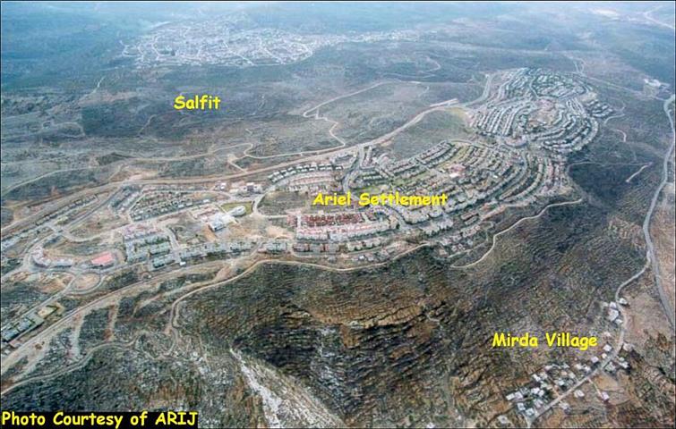
According to the village boundary delineated during the British mandate, the original land of Iskaka covered nearly 6500 dunums. In 1967 the Israeli occupation forces started confiscating agricultural lands from the village and in 1978, 1000 dunums of the village lands were confiscated and Ariel settlement replaced the olive groves. Ariel settlement is currently the second largest settlement in the West Bank (after Ma'ale Adumim) with an area of 5178 dunums and is inhabited by 18,000 settlers. Ariel is situated on lands confiscated from Salfit, Mirda, Kufur Harith and Iskaka.
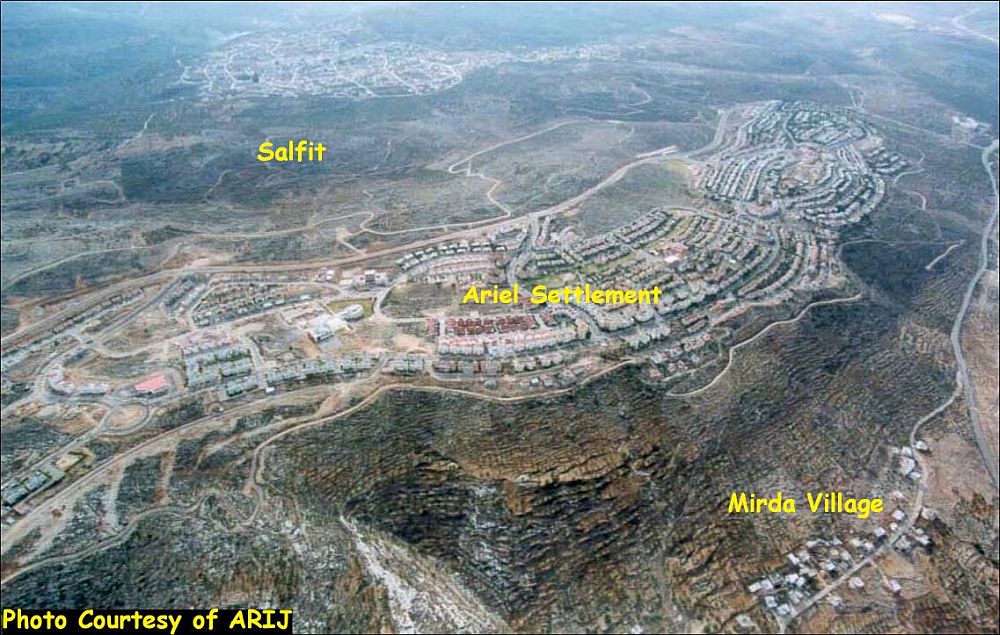
Today, the village of Iskaka is surrounded by a set of settlements; Ariel from the west, Kfa Tapuah from northeast and Rachelim from the east, See map..
The Segregation Wall
In 2003, as part of phase one of constructing the Segregation Wall, 5 km of the wall were built in Salfit Governorate, from Mas-ha village to Elkana settlement. On May 9, 2004, The Israeli occupation forces handed Iskaka villagers military order number (04/ 45/T Judea & Samaria 2004) stating the confiscation of 267.4 dunums of their agricultural lands for the construction of the Segregation Wall, see a translation of the military order.
|
Israel Defense Forces According to my authorities as a Military Chief Commander in the Region of Judea and Samaria, and as I believe that it is imperative for military reasons due to the special security situation in the region, I order the following: 1- The 'Map' signed in scale 1:10000 and attached to the order is an essential part of this order. The 'Lands' : An area of land which is 267.4 dunums(3116 meter long and 100 meters wide) marked in red in the map :
2- I announce by that the above mentioned lands are seized for military reasons 3- The IDF seize the lands and have an absolute control over it that is given to the officer of the central command officer of lands who is responsible in the ministry of defense. 4-These copies are to be given by the District Co-ordination Office 'The DCO' of Qalqiliya to the owners of land. 5- Copies are found with maps for those who are interested in the following places:
6- The owners of land have the right to go to the DCO in Qalqiliya in order to get more information about their right of land use expenses and compensation. 7- The Validity of this order starts at the date signed till 31/12/2007 8- The name of this order is: ' Order to seize lands n0 04/45/T (Judea & Samaria ) 2004'
Mosheh Kaplenski |

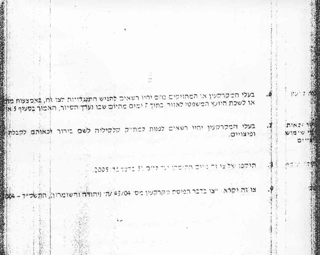
Military order number 04/45/T
Phase two of the Segregation Wall in Salfit Governorate started in June 2004 were land razing took place on the lands of Salfit and Iskaka around Ariel block, but works were halted due to appeals raised to the Israeli High Court by the local residents in the Governorate. However, in January 24, 2005, constructions were resumed following a decision from Israeli attorney general Mazouz to resume the works. Lands are being razed on a 4 km section on Iskaka and Salfit lands and will isolate around 6700 dunums from Salfit city and 550 dunums from Iskaka village.
The Wall around Ariel Block will extend over 9 km and will confiscate 24972 dunums from the villages of Haris, Kafer Haris, Marda, Iskaka and Salfit city.
This section of the Segregation Wall is the deepest inside the West Bank as the Wall around Ariel Block is 22 km away from the Green line (the armistice line of 1948 and the internationally recognized border between the Palestinian state and Israel). To get around the international disagreement of such a deep penetration, the Israeli Government claims that Ariel envelope is part of the depth wall but eventually will be joint to the main Wall.
Ariel envelope offsets a distance of 300 to 650 meters (aerial distance, the actual distance is larger due to the topography) away from the boundaries of the settlement confiscating thousands of dunums from the nearby villages that the villagers can't access.
Most of the villagers in Salfit governorate depend mainly on agricultural production as their main source of income. Farmers are now hindered from accessing their agricultural lands and therefore will have to search for alternative ways to earn a living. The impact of the Wall will lead to further economic and environmental devastation, increasing levels of poverty, and increasing despair and desperation among Palestinians as they witness Israeli occupation authorities appropriate more land for the construction of the Segregation Wall.
The International Court of Justice (ICJ) in its ruling on July 9, 2004 considered the Wall as illegal, demanded Israel to stop its construction, dismantle the already built part and compensate the Palestinian for the damages inflicted on them. In addition the segregation wall will cause a shift to the 1967 borders, thus breach the United Nations resolutions 242, 338, the International Laws, human rights and Geneva Conventions. Furthermore resuming the construction of the Wall at this time (after the Palestinian elections) will jeopardize the aspirations and efforts to reach a peaceful solution to the Arab-Israeli conflict in the Middle East.
Read also:-
Prepared by:
The Applied Research Institute – Jerusalem


