• About The Project
  • Palestine in Century
  • Selected Maps
  • Glossary
  • About ARIJ
  • About LRC
  • By Year
    • Case Studies By Year
    • Daily Report By Year
Friday, May 9, 2025
POICA
No Result
View All Result
  • Home
  • Settlements
    • New Israeli Settlements
    • Settlement Expansion
  • Israeli Violations
    • Agriculture
    • Confiscation
    • Demolition
    • Environment
    • Eviction of Palestinians
    • Settlers Attacks
  • Bypass Roads
  • Israeli Plans
  • Segregation
    • Checkpoints
    • Closure
    • Separation Plans
  • Military Orders
  • Reports
    • Daily Report
    • Monthly Report
    • Quarterly Report
No Result
View All Result
POICA
No Result
View All Result

Israeli Settlers’ road planned over ancient historical site in Hebron’s Old City

March 9, 2017
in Military Orders


The Israeli occupation army issued a military order on February 11th, 2005, carrying the number of ( T/17/05) and signed by the Israeli general commander Yaeer Nafeh. The order states the confiscation of Palestinian lands in Tel Rumaida area, in the western part of Hebron's Old City to build a new road for Israeli settlers that connects ' Ramat Yashai' settlement in Tel Rumaida with the three other settlements in the heart of Hebron city – ' Beit Hadasa, Beit Romano, Abraham Avino' .

   
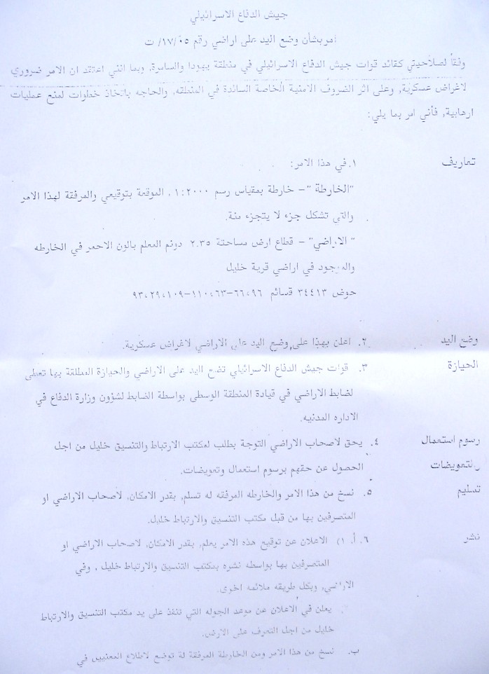
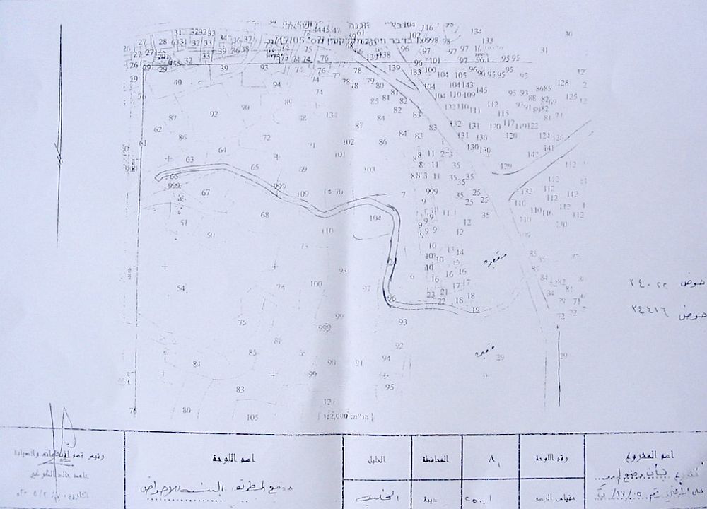
( Photo 1 and 2- Copy of the military decree in Arabic and the attached map)

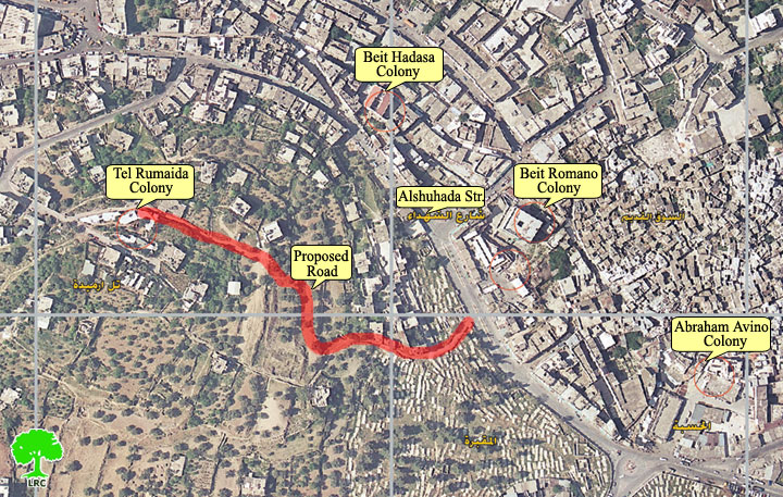
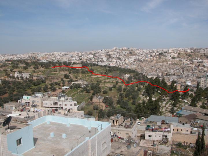
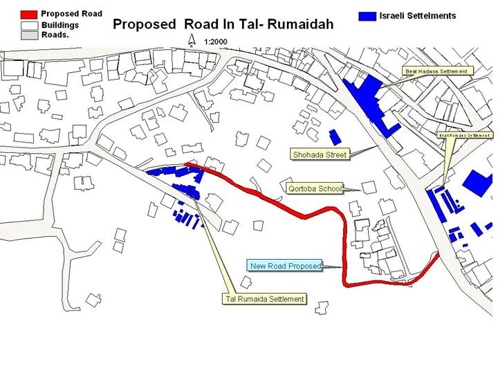
The road is planned to start from the middle of Al Shuhada street between ' Beit Rumano' and ' Abraham Avino' up to 'Ramat Yashai ' settlement in Tel Rumaida.


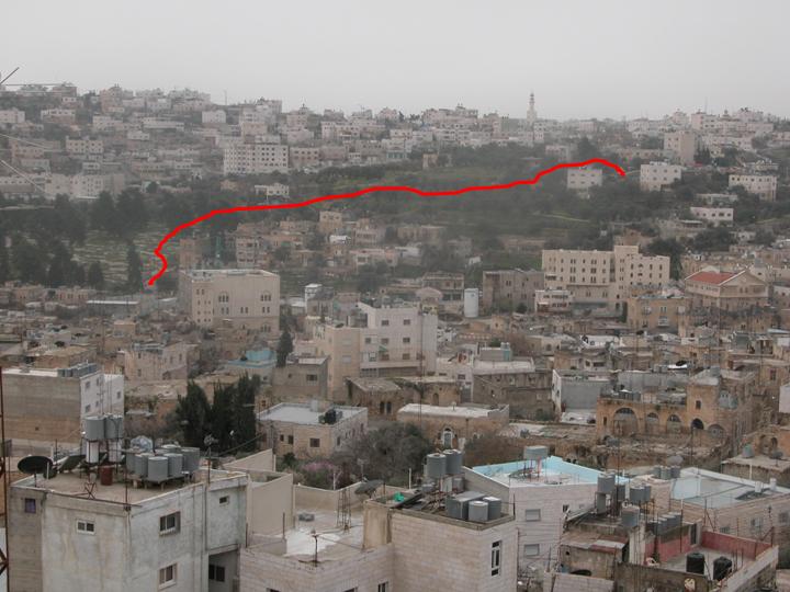
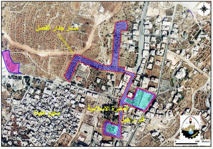
(Photo 3- Aerial photo of Hebron's old city shows the route of the planned road)

( Map 1- proposed road in Tel Rumaida and settlements)

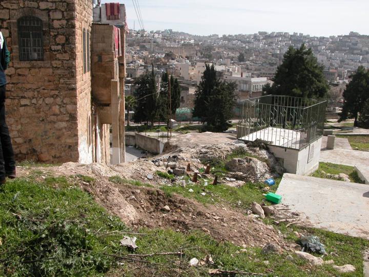
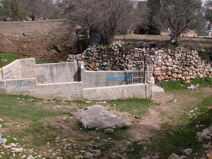
Creating this road will lead to the demolition of historical houses, Muslims' graves, uprooting of long – lived olive trees and destroying ancient monuments in the area. Tel Rumaida area has been known as one of the famous archeological sites throughout centuries. It has been subjected to many Israeli settlers' attacks. See Photo 4 and Photo 5

 
( Photo 4 and Photo 5– Proposed route of road threatens graves, houses and olive trees- Photos courtesy of LRC)

Hebron Rehabilitation Committee has filed a complaint against the Israeli occupation authorities. Objections against the aforementioned order were also submitted by the affected Palestinian residents to the Israeli Military Objection Committee in Beit El in a procedure before setting up a court case against the Israeli high court.


(Photo 6- Some of the graves and houses threatened with demolition by the proposed road–
(Photo courtesy of LRC)

The targeted land is owned by several Palestinian families, including the families of Abu Sakur, Abu Munshar, Igneiby, Al Saheb, Abu Ghalyoon, in addition to a Muslim cemetery, Al Saqawati Muslim shrine, and Al Ain Al Jadeda (water spring) which belong to the Islamic Waqf ( Islamic Trust) in Hebron.

( Photo 7- Al 'Ein Al Jadeda and Water spring  threatened with demolition by the proposed road)
(Photo courtesy of LRC)
 

For more details, the following table details information about the land targeted for confiscation by the aforementioned military order:

No. of Basin

No. of Parcel

Name of Owner

34416

63

Khalil Isma'il Abu Sakur

34416

64

Hasan Mahmud AlSaheb

34416

65

Mahmud Khamis Al Saheb

34416

93

Abdul Mu'ti Khalil Abu Munshar

34416

96

Islamic Waqf ( Al Ain Al Jadeda)

34416

104

Zaglul Salim Abu Ghalyoon

34416

109

Waqf of Igneiby family

34022

29

Islamic Waqf ( Islamic cemetery)

34022

26

Heirs of Hasan Abu Awad Shahin


Building the supposed road will reinforce the Israeli colonial presence in Hebron city and will increase the Israeli control over Palestinian areas, which, in effect, will create more tension in the city. Meanwhile, it will add more pressure on Palestinian residents, forcing them out of area.


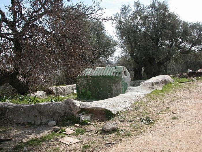
( Photo 8- an orchard of long – lived olive tree threatened with uprooting by the road)
(Photo courtesy of LRC)

Implementing this decree violates Hebron Protocol which was signed between the Palestinian and the Israeli sides in January, 1997 as part of the peace agreements.


( Photo 9- Al Saqawati Muslim shrine- 800 years old- is among the Muslim shrines and graves to be destroyed)
(Photo courtesy of LRC)

Historical background to Tel Rumaida

Hebron city was built originally around Tel Rumaida area. According to archeological excavations carried out by several missions, Tel Rumaida area is considered to be an archeological site that witnessed many civilizations throughout history. It is dated back to the Bronze period, the Iron period, the Roman period, Byzantine period and Islamic period.

Canaanites had built their political capital in Tel Rumaida more than 5500 years ago. Ein Al Jadeda in the east side of that area used to be the main water resource for Hebron. Hebronites had planted the fertile Hebron valley  ' Wadi Al Khalil Al Khasib' in that area.

Many archeological excavations had taken place in Tel Rumaida area. The first one was during the period from 1963-1966 by the American mission under the supervision of archeologist Philip Hammond. Then, in 1982, 1985, 1986 and 1999 by Israeli archeological missions. All of the excavations and diggings have emphasized on the historical importance of Tel Rumaida and have approved the fact that the area had witnessed several civilizations.

Tel Rumaida area is considered an archeological site since 1944, when the British Mandate listed it within the historical sites of Palestine. Thereafter, the Jordanian government stressed that on it during its control of the West Bank until 1967.

Following the Israeli occupation of the West Bank in 1967, the Israeli government issued a military order considering the area as an 'archeological site' and prevented any constructions that might change its 'historical characteristics'. But, within its settlement strategy, Israel has allowed a group of settlers in 1984 to set several mobile homes (caravans) over that archeological site. Thereafter, the Israeli government has given blind eye to enlargement activities on the part of Israeli settlers, who, in 2000, succeeded to begin the construction of a new permanent and multi storey residential building on top of this historical archeological site.

The Land Research Center calls upon all local, regional and international bodies to stop the implementation of this dangerous military decree by intervening with the Israeli officials at all levels.  


Prepared by
The Land Research Center
LRC

Recommended For You

الأراضي الفلسطينية بين الذرائع الأمنية والأطماع الاستيطانية – “الأمن، الآثار، والطبيعة كحجج لاقتلاع الفلسطينيين من أراضيهم”

by arij
April 15, 2025
0

مقدمة شهدت الأراضي الفلسطينية في الضفة الغربية المحتلة على مدار عقود طويلة سياسة ممنهجة من المصادرة الإسرائيلية للأراضي، حيث تبرر سلطات الاحتلال الإسرائيلي هذه السياسة بمجموعة من الذرائع...

Read moreDetails

سلطات الاحتلال الإسرائيلي تخصص ما يزيد عن 16,000 دونما من الأراضي الفلسطينية التي تحيط بالمستوطنات الإسرائيلية لأغراض الرعي

by arij
February 12, 2025
0
سلطات الاحتلال الإسرائيلي تخصص ما يزيد عن 16,000 دونما من الأراضي الفلسطينية التي تحيط بالمستوطنات الإسرائيلية لأغراض الرعي

  أصدرت سلطات الاحتلال الإسرائيلي في العاشر من شهر شباط من العام 2025 ستة أوامر عسكرية جديدة تقضي"بإعلان عن نية المسؤول عن الأملاك الحكومية وأملاك الغائبين على المصادقة...

Read moreDetails

Sheep Pens in Bardala Village Falls to a systematic Attack of the Israeli Army, Aiming to Displace the Community

by arij
January 30, 2025
0
اخطارات اسرائيلية بوقف العمل في قرية بردلة

The Israeli Settlement Council Organization stormed the village of Bardala, northeast of Tubas, targeting a sheep pen owned by Mr. Louay Abu Rushdi. The escorting occupation Army issued...

Read moreDetails

اخطارات اسرائيلية بوقف العمل في قرية بردلة

by arij
January 30, 2025
0
اخطارات اسرائيلية بوقف العمل في قرية بردلة

  الموقع: بردلة -الأغوار الشمالية / محافظة طوباس الجهة المعتدية: المجلس الأعلى للتخطيط /تنظيم مجلس المستوطنات الجهة المتضررة: السيد لؤي ابو رشدي الانتهاك: وقف عمل لحظيرة أغنام تفاصيل...

Read moreDetails

إخطارات بهدم بركسات سكنية وزراعية في تجمع عاطوف

by arij
January 23, 2025
0
Demolition Notices for Residential and Agricultural Structures in the Atouf Community

  الانتهاك: إخطارات بهدم مسكن وحظائر اغنام الموقع: الرأس الاحمر- عاطوف / محافظة طوباس الجهة المعتدية: تنظيم مجلس المستوطنات الجهة المتضررة: السيد ثائر حسين تفاصيل الانتهاك أقدمت قوات...

Read moreDetails
Next Post
إلى قبر راحيل…طريق معبد بمعاناة الفلسطينيين

إلى قبر راحيل...طريق معبد بمعاناة الفلسطينيين

LATEST NEWS

الأراضي الفلسطينية بين الذرائع الأمنية والأطماع الاستيطانية – “الأمن، الآثار، والطبيعة كحجج لاقتلاع الفلسطينيين من أراضيهم”

by arij
April 15, 2025
0

........................................................

الطرق الالتفافية الاسرائيلية وأثرها على البيئة الفلسطينية

انتهاك للطبيعة والهوية في الأراضي الفلسطينية المحتلة

by arij
March 17, 2025
0

........................................................

Israel Advances Settlement Plan on Ancient Olive Groves on lands of Beit Jala city, Violating International Law and depriving Palestinians their lands

إسرائيل تمضي قدمًا في مخطط استيطاني جديد على أراضي مدينة بيت جالا، في انتهاك للقانون الدولي وحرمان الفلسطينيين من أراضيهم

by arij
April 29, 2025
0

........................................................

Israel Advances Settlement Plan on Ancient Olive Groves on lands of Beit Jala city, Violating International Law and depriving Palestinians their lands

Israel Advances Settlement Plan on Ancient Olive Groves on lands of Beit Jala city, Violating International Law and depriving Palestinians their lands

by arij
April 29, 2025
0

........................................................

flag_yellow_lowEU-PfP-Logo

This website has been produced with the assistance of the European Union. The contents of this publication are the sole responsibility of ARIJ & LRC and can in no way be taken to reflect the views of the European Union.

© 2025 Copyright ARIJ . All Rights reserved. .

No Result
View All Result
  • Home
  • Settlements
    • New Israeli Settlements
    • Settlement Expansion
  • Israeli Violations
    • Agriculture
    • Confiscation
    • Demolition
    • Environment
    • Eviction of Palestinians
    • Settlers Attacks
  • Bypass Roads
  • Israeli Plans
  • Segregation
    • Checkpoints
    • Closure
    • Separation Plans
  • Military Orders
  • Reports
    • Daily Report
    • Monthly Report
    • Quarterly Report

© 2025 Copyright ARIJ . All Rights reserved. .