General introduction:-
In case the Wall, with all its three stages, is erected it will transform the West Bank into three, unconnected cantons an area of which does not surpass 2700 km2. Such an area constitutes about 10% of the area of Historic Palestine and about 50% of the area of the West Bank. The length of the Wall would reach about 1,000 kilometers as the length of its eastern wing is expected to reach 300 kilometers while the length of its western and northern wings is expected to reach 700 kilometers.
The percentages of the annexed lands in the governorates of the West Bank vary according to the number of settlements in it. As such, the governorates located at the heart of the West Bank stand to lose most of its lands, especially the Governorate of Jerusalem which will lose more than 90% of its lands. The Governorates of Jericho and Bethlehem will lose the same percentage as Jerusalem while the Governorates of Hebron, Tubas and Ramallah stand to lose a bit more than 50% of their lands for the benefit of the Wall. The rest of the Governorates of the West Bank will lose a lesser percentage of their lands.
Taking the above-mentioned facts into consideration, one can only conclude that creating a viable Palestinian state that has geographical and population continuity is virtually impossible with the existence of the Israeli Racist Isolation Wall.
Beit Ula town
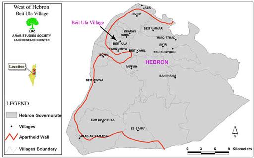
It is located 16 kilometers to the northwest of Hebron city, and about 5 kilometers to the east of the Green Line. The town has a total area of 24 Square km, 60% of which is agricultural lands. Beit Ula houses a population of 10500 inhabitant, 60 % of whom work in agriculture. It is known for its olive, almond and grape products, as well as the un-irrigated seasonal crops and irrigated crops. The town lost about 9000 dunums of its border lands during the 1948 war.
( Map 1- Beit Ula location)
Beit Ula and the Wall
Israeli bulldozers, under heavy army protection, started during the second week of November the construction of the Segregation Wall in Beit Ula lands. According to the military order No. 64/04/T which was issued on July 8th, 2004 ( a copy of which is attached to this report -Picture No. 1), about 2500 dunums of Beit Ula agricultural lands located to the west of the town, mainly in Khalayel Attus ( 5 kms to the west of the town) will be annexed into Israel's proper or separated from their real owners by the erection of the Wall.
On November 11, 2004, three days before Eid Al Fitr (breaking of Ramadan fasting) Israeli bulldozers under heavy protection of Israeli army and police began the bulldozing process of about 5 kms long strip of land that will be the basis for laying the path of the Wall. In case this Segregation project is completed, it will affect a total of about 100 families from Beit Ula (Attached is a copy of the names of victimized families who will be loosing part or all of their lands).
Indirect effects will be entitled on quite many other families whose lands are located near the proposed path of the Wall because, like other locations in the West Bank, these families will be deprived access to their lands which, eventually, will lead to total annexation in to Israel.
(Picture 1- A copy of the military order )
The occupation violates its occupation law
The Israeli occupation authorities have violated their own occupation law which gives the affected land owners the right to object the military order after it had been issued and circulated.
The land owners did so, but the Israeli authorities didn't wait until the court decisions have been issued. Instead, the Israeli bulldozers started work even deeper inside the Palestinian lands which haven't been mentioned in the original order.
Impact of the Wall on Beit Ula town
The negative impacts of the Wall on Beit Ula town are no different from other places in the West Bank affected by the Wall. Here are the effects on Beit Ula:
1. The bulldozing of about 250 dunum of agricultural land leading to the uprooting of at least 3000 trees of olive and almond trees;
2. The devastation of 150 dunum of land used for ground and seasonal crops;
3. The separation of about 2000 dunum as followed:
A. 850 dunum of plain or semi plain lands cultivated with cereals, irrigated and un-irrigated crops;
B. 1150 dunum of graze land which is the only land available for almost 7000 heads of sheep and goats in the area. Also, these pasture lands contain many caves and sheds used as shelters by shepherds in different seasons of the year.
The aforementioned losses are estimated at hundreds of thousands of dollars inflicted on about 100 nucleus families from the village ( see the attached list of the names of victimized families).
Picture 2- a general view of agricultural lands in Beit Ula
Anti Wall activities
The Beit Ula residents along with its social and service institutions, municipality, schools and national dignitaries supported by delegates from the National Land Defense Committees and lawyers staged a peaceful march to Khalayel Attus where the Wall works are being carried out.
Picture 3- Beit Ula residents peacefully march towards the affected lands
Marchers carried placards and posters condemning the establishment of the Wall and demanding an immediate halt of all Wall works. The participants called upon international community, peace loving groups, anti apartheid bodies and human rights organizations to hold their responsibilities and pressure Israel to stop its Wall project in the occupied Palestinian territories.
The Israeli army and security personnel present at the scene of the peaceful demonstration faced the demonstrators with tear gas, rubber and live bullets, even high velocity bullets, causing the injury of more than ten people, two of whom suffer serious wounds in the back and head. They remained in critical conditions at the time this report was written.

picture 4- Beit Ula residents perform prayers on their threatened land
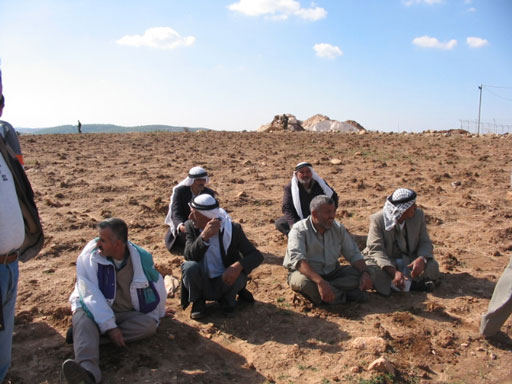
picture 5- Land owners staging a sit in on their threatened land
The following is a list of names of victimized families in Beit Ula town- Hebron
|
Names of Family heads |
Location |
No. of Basin |
Parcel # |
Area |
|
Mohammed Taha Amla |
Wadi ar Raqati- Abu Asida |
7,15 |
30,6 |
19,4 |
|
Mohammed Othman Amla |
Wadi ar Raqati |
7 |
31 |
19 |
|
Ahmad Abed Rabu Amla |
Wadi ar Raqati |
7 |
33 |
44 |
|
Mohammed Shaker Amla |
Wadi ar Raqati |
7 |
24,43 |
27,20 |
|
Mahmud Ibrahim Amla |
Wadi An Najjar |
7,7 |
214,215 |
19,17 |
|
Hamdan Mahmud Amla |
Wadi An Najjar |
7 |
216 |
17 |
|
Hasan Salim Amla |
Wadi An Najjar |
7 |
217,220 |
15,7 |
|
Mohammed Salim Amla |
Wadi An Najjar |
7 |
218 |
8 |
|
Naji Munjid Abdul Nabi |
Wadi An Najjar |
7 |
221 |
1 |
|
Abdallah Sulieman Amla |
Wadi An Najjar |
7 |
222 |
3 |
|
Rushdi Salim Abas |
Wadi An Najjar |
7 |
223 |
4 |
|
Abdul Salam Ibrahim Amla |
Wadi An Najjar |
7 |
224 |
10 |
|
Darwish Khalil Amla |
Sh'ib Al Hasanat |
12 |
1 |
79 |
|
Odeh Khalil Amla |
Wadi An Najjar |
12 |
4 |
79 |
|
Hammad Mohammed Amla |
Wadi An Najjar |
12 |
5 |
79 |
|
Salama Othman Amla |
Abu Asida |
15 |
3 |
25 |
|
Mohammed Badwan Othman |
Abu Asida |
15 |
4 |
25 |
|
Ahamd Abdul Aziz Othman |
Abu Asida |
15 |
5 |
25 |
|
Mohammed Abdul Nabi Othman |
Abu Asida |
15 |
7 |
13 |
|
Khalil Abdul Aziz Amla |
Sh'ib Al Asara |
12 |
3,2 |
79,159 |
|
Abdul Mu'ti Abdallah Nimr Amla |
Khalayel Attus |
7 |
1 |
55 |
|
Mohammed Amro Nimr Amla |
Khalayel Attus |
7 |
2 |
55 |
|
Yusif Amro Nimr Amla |
Khalayel Attus |
7 |
3 |
36 |
|
Abdul Hamid Amro Nimr Amla |
Khalayel Attus |
7 |
3 |
40 |
|
Mohammed Abdallah Nimr Amla |
Khalayel Attus |
7 |
6 |
38 |
|
Mahmud Rashid Dabus Amla |
Khalayel Attus |
7 |
7 |
38 |
|
Hasan Rashid Dabus Amla |
Khalayel Attus |
7 |
9 |
16 |
|
Ibrahim Abdul Jabbar Amla |
Khalayel Attus |
7 |
17,14 |
2,10 |
|
Mohammed Abdul Wahab Nimr Amla |
Khalayel Attus |
7 |
13,16 |
2,10 |
|
Musbah Abdul Fattah Amla |
Khalayel Attus |
7 |
15 |
12 |
|
Talab Abul Rahman Amla |
Khalet Murshid |
7 |
567 |
25 |
|
Ahamd Abdul Karim Al 'Adam |
Khalet An Nahla |
7 |
478,479,480,481 |
20,20,20,20 |
|
Musal I'llian Al 'Adam |
Khalet An Nahla |
7 |
482 |
159 |
|
Abdul Karim Al Haj Al 'Adam |
Khalet Hatim, Um Akhanazir |
7,9 |
235,5 |
30,19 |
|
Mohammed Ali Al 'Adam |
Khalet Hatim, Um Akhanazir |
9,10 |
6,16 |
19,50 |
|
Abdul Hafiz Mahmud Al 'Adam |
Wadi Al Qalamun |
7 |
180,183,191 |
10,10,23 |
|
Salim Aqel Al 'Adam |
Wadi Al Qalamun |
7 |
177,185,212 |
24,10,167 |
|
Mahmud Sulieman Al 'Adam |
Wadi Al Qalamun |
7 |
189, 190, 191, 178,192,181 |
10,5,13,8,19 |
|
Abdul Fattah Al 'Adam |
Wadi Al Qalamun |
7 |
156 |
70 |
|
Issa 'Imul Al 'Adam |
Wadi Al Qalamun |
7 |
207 |
4 |
|
Abed Rabu Zaghir Mohammed Sabah |
Wadi ar Raqati- Abu Asida |
7,15 |
37,13 |
44,25 |
|
Isma'il Abdul Qader Fari' |
Wadi ar Raqati |
7,7 |
38,40 |
4,10 |
|
Falah Abdul Fattah |
Abu Asida |
15 |
11 |
8 |
|
Mahmud Abdul Hadi Sabah |
Abu Asida |
15 |
12 |
30 |
|
Mohammed Abdel Rahman Al Atrash |
Wadi Al Qalamun |
7 |
160,184,186 |
7,39,14 |
|
Abdul Rahim Abdul Karim Al Atrash |
Wadi Al Qalamun |
7 |
169 |
8 |
|
Abdul Jabbar Ali Jaber |
Wadi ar Raqati- Abu Asida |
7,15 |
19,2 |
22,28 |
|
Mohammed Abdul Fattah Jaber |
Wadi ar Raqati- Abu Asida |
7,15 |
20,21,23,32,34,9 |
44,22,10,43,44,25 |
|
Mahmud Abdul Fattah Jaber |
Wadi ar Raqati |
7 |
22,24 |
10,4 |
|
Abdallah Jaber As Sarahin |
Wadi ar Raqati |
7 |
29 |
34 |
|
Sabha Mohammed Jaber |
Wadi ar Raqati- Abu Asida |
7,15 |
35,10 |
23,12 |
|
Ahamad Jaber As Sarahin |
Wadi ar Raqati |
7 |
39,41 |
10,4 |
|
Abdul Qader Khalil As Sarahin |
Wadi ar Raqati |
7 |
569 |
14 |
|
Hasan Abdul Fattah Jaber |
Abu Asida |
15 |
1 |
5 |
|
Mahmud Abdul Fattah Abu Nasir |
Khalayel Attus |
7 |
11 |
18
|
|
|
|
|
2427 |
|
Note: In addition to the above mentioned central names, there are another 37 sub names who owned lands in the same areas. With this, the total number of nucleus families affected by the Wall construction in Beit Ula will be 92 .
Prepared by
The Land Research Center
LRC


