• About The Project
  • Palestine in Century
  • Selected Maps
  • Glossary
  • About ARIJ
  • About LRC
  • By Year
    • Case Studies By Year
    • Daily Report By Year
Tuesday, July 1, 2025
POICA
No Result
View All Result
  • Home
  • Settlements
    • New Israeli Settlements
    • Settlement Expansion
  • Israeli Violations
    • Agriculture
    • Confiscation
    • Demolition
    • Environment
    • Eviction of Palestinians
    • Settlers Attacks
  • Bypass Roads
  • Israeli Plans
  • Segregation
    • Checkpoints
    • Closure
    • Separation Plans
  • Military Orders
  • Reports
    • Daily Report
    • Monthly Report
    • Quarterly Report
No Result
View All Result
POICA
No Result
View All Result

New Developments on the East & Southeast Terrains of Bethlehem Governorate

July 15, 2004
in Bypass Roads
New Developments on the East & Southeast Terrains of Bethlehem Governorate


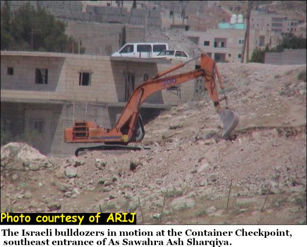
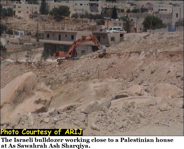
On July 6, 2004, the Israeli bulldozers commenced work in the area most recognized to the Palestinian as ''the Container Checkpoint'' located at the hilltop of the Qidron valley road; better known as the ''Wadi Al-Nar road'' located right at the southeast entrance of As-Sawahra Ash-Sharqiya village. See Photo 1 located at the hilltop of the Qidron valley road; better known as the ''Wadi Al-Nar road'' located right at the southeast entrance of As-Sawahra Ash-Sharqiya village.


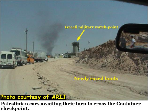
The Container Checkpoint is significant to the life of the Palestinian general population as it constitutes the one and only mean of access between the West Bank southern districts (Hebron & Bethlehem) and the northern ones (Ramallah, Nablus, Jenin, Qalqilyia, Tulkarem, Salfit & Jericho). The Container Checkpoint literally divides the West Bank into two separate geographical entities where crossing from one part to the other requires special permit issued by the Israeli Civil Administration. See Photos of Al Container Checkpoint

What is the Container Checkpoint?

The Container is a place where an old Palestinian man from As-Sawahra Ash-Sharqiya village had his shop set in. As the Israeli Army placed the checkpoint across the road from the container, people tended to associate both the container and the Israeli checkpoint together to identify the area where the Israeli checkpoint stand.

Prior to the current Intifada (erupted in September 2000), the location of the Container Checkpoint did not exist but occasionally (once every 7-10 days), an Israeli Army patrol would temporary (no more than an hour) make a road block to check ID's of Palestinians passing through the area. At the time the Intifada began, the area turned to almost a permanent location to Israeli patrols where roads blocks became a frequent practice. Consequently, the lives of the Palestinians moving through that area in both directions became more aggravating as (i.e.) a regular traveling time from Bethlehem to Ramallah through Wadi Al-Nar takes an even 50 minutes and since the checkpoint became permanent, 150 minutes ride would seem like a bless.

Chronology of the Container Checkpoint

Before the year 2000, the Container Checkpoint was no more than infrequent stop of Israeli patrols, afterward; the Israeli Army blocked the road with concrete cement blocks; restricted movement through the checkpoint, which lasted up until 2002 when the Israelis installed an iron gate. The procedures from that time on became more difficult as the Israeli soldiers at the gate randomly allowed access to Palestinians passing through the Iron Gate to both directions.

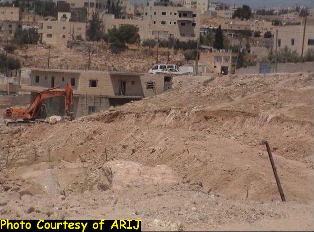
In midyear of 2003, Israel reshaped the area and rigged a cylinder concrete watchtower as procedures to cross the checkpoint increasingly became problematical. Apparently Israel has no intentions to abandon the checkpoint any time in the near future, but is looking to tighten its grip on this vital location and continue to manipulate the lives of thousands Palestinians crossing the gate everyday. During the Israeli disfigurement of the checkpoint area, the Israeli Army coercively evacuated the original spot of the container shop and rigged concrete blocks in its place; however, the people still identify the Israeli checkpoint as they always did.

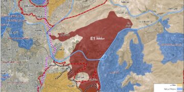
On June 14, 2004, the government of Israel decided to turn the container checkpoint to fortified crossing area for Palestinians as a military order under # (03/03/T) was issued by the Israeli chief commander to confiscate 4.85 Dunums to reshape the area adjacent to the checkpoint area. The new plans include several watchtowers (already one of which exists) extensive amassing of concrete blocks, circulating the designated area with barbwires, constructing of passageways as in access strips for individuals, public & private transportations provided that proper authorization from the Israeli civil administration is acquired. See map 1 of the above-mentioned military order


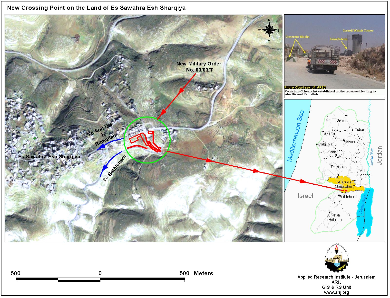
The Israeli wasted no time and commenced the work at the area 22 days (July 6, 2004) following the issuance of the military order. Click here for more information


Clearly, Israel is will aware of the significance of the checkpoint location; being the only link between the southern & northern districts of the West Bank. The Israeli military order # 03/03/T will indubitably put an end to any potential plans for a viable Palestinian State with geographical contiguity.

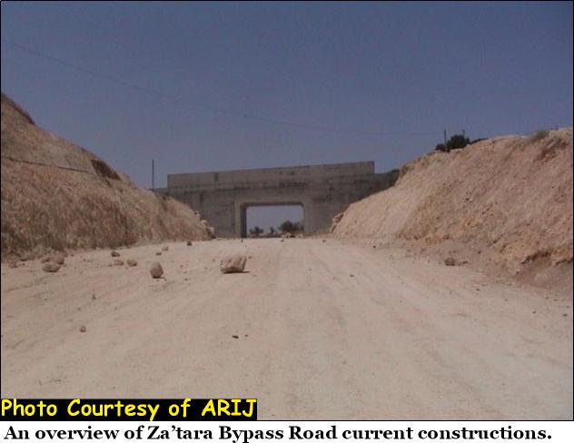
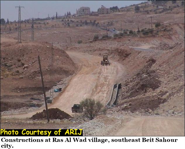
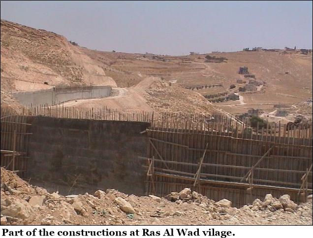
Constructions continue at Za'tara Bypass Road:-

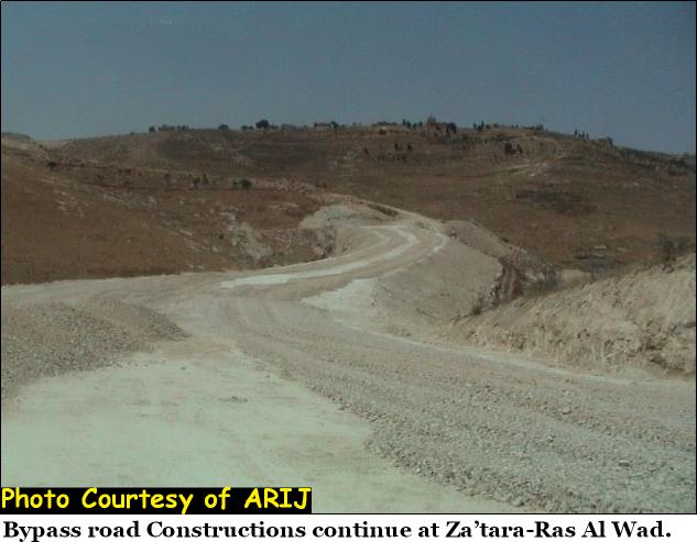
The Israeli Army continued its operations on the eastern territorial grounds as construction of Za'atara bypass road continues over thousands of Dunums that belongs to Palestinians in the area. Click here for more information.

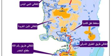
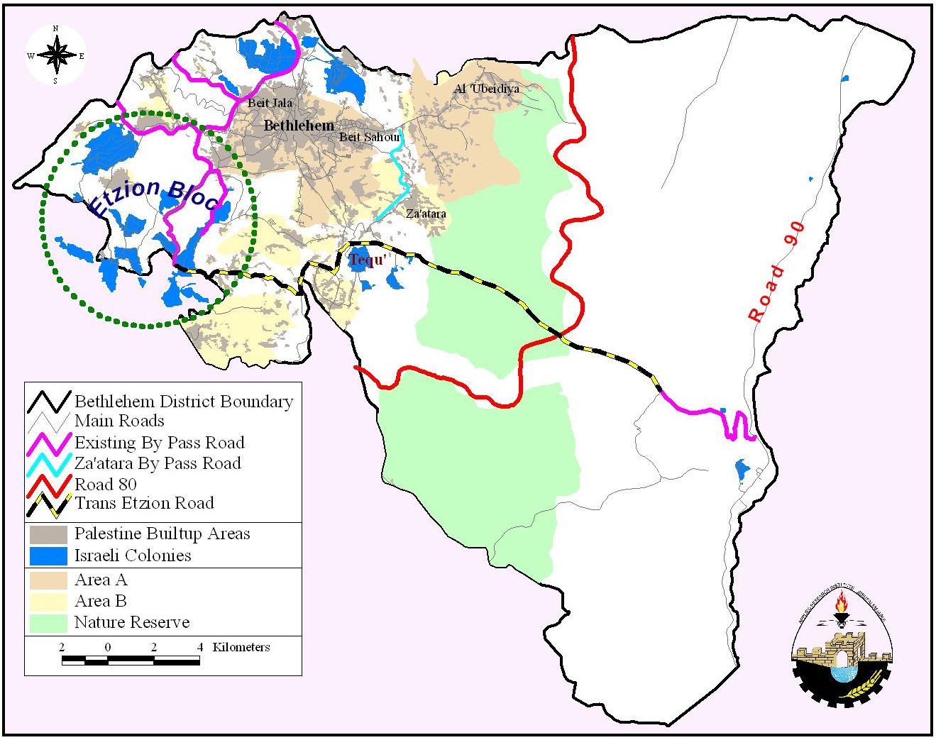
The road that penetrates through 8 Km of Palestinians lands intends to link Israeli settlements southeast of Bethlehem district with Jerusalem, along Abu Ghneim (Har Homa settlement), See Map 2. .


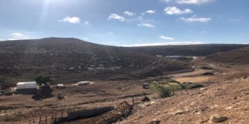
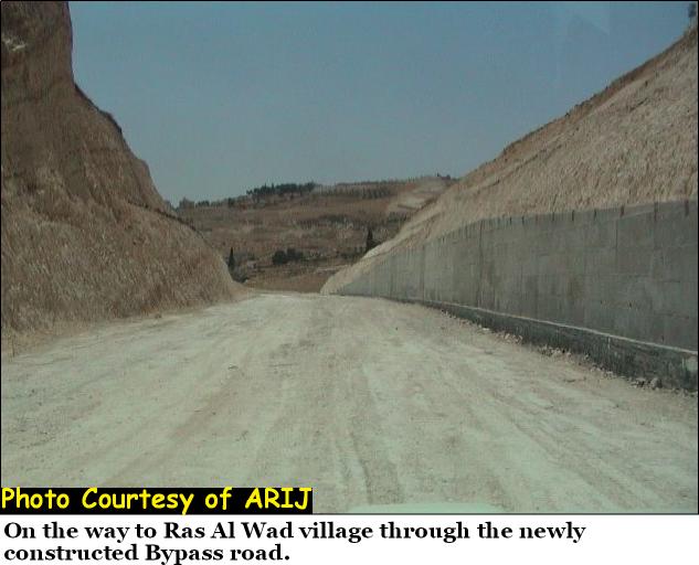
The Israeli bulldozers are still deforming the lands between Za'atara & Al-Fourdis for the bypass road; scheduled for completion before the end of 2004. See Photos of constructions


Prepared by:
The Applied Research Institute – Jerusalem


Recommended For You

شق طريق استيطاني جديد يهدد سبل العيش في قرية بردلة

by arij
January 13, 2025
0
New Israeli Settlement Road Construction and Its Impact on the Village of Bardala in the Jordan Valley

المكان: تجمع بردلة- محافظة طوباس/الأغوار الزمان: سبتمبر 2024 الجهة المتضررة: أهالي قرية بردلة والقرى المجاورة الجهة المعتدية: ما تسمى بالإدارة المدنية الاسرائيلية الانتهاك: شق طريق استيطاني تفاصيل الانتهاك:...

Read moreDetails

New Israeli Settlement Road Construction and Its Impact on the Village of Bardala in the Jordan Valley

by arij
December 31, 2024
0
New Israeli Settlement Road Construction and Its Impact on the Village of Bardala in the Jordan Valley

  The construction of new settlement infrastructure in the occupied Palestinian territories has profound implications for local communities, threatening livelihoods, increasing isolation, and impairing socio-economic vulnerabilities. This case...

Read moreDetails

الطرق الالتفافية الاسرائيلية وأثرها على البيئة الفلسطينية

by arij
January 16, 2024
0
الطرق الالتفافية الاسرائيلية وأثرها على البيئة الفلسطينية

  الاعتداءات الإسرائيلية على الفلسطينيين لا تقتصر على التنكيل بالافراد، أو وضع القيود على الحركة والتنقل، أو استهداف المنازل والمنشات، أو مصادرة الأراضي، أو نهب الموارد والمصادر الطبيعية،...

Read moreDetails

Israeli Colonists Take Over an Agricultural Road in Ya’bad town / Jenin Governorate

by arij
January 12, 2022
0
Israeli Colonists Take Over an Agricultural Road in Ya’bad town / Jenin Governorate

  Violation: Taking over an agricultural road for the favor of colonization. Location: Ya’bad town / Jenin Governorate. Date: October 17th 2021. Perpetrators: Mevo Dotan Colony. Victims: Farmers...

Read moreDetails

New Colonial road to Be Opened on Sarta Village lands / Salfit Governorate

by arij
July 17, 2021
0
New Colonial road to Be Opened on Sarta Village lands / Salfit Governorate

  Violation: Opening a new Colonial Roads. Location: Sarta village/ Salfit Governorate. Date: June 1st 2021. Perpetrators: The Israeli Illegal Industrial Colony (Barkan). Victims: Farmers from the village....

Read moreDetails
Next Post
The Palestinian Village Artas Falls in the Vortex of the Segregation Wall

The Palestinian Village Artas Falls in the Vortex of the Segregation Wall

LATEST NEWS

أمر عسكري إسرائيلي يستهدف أراضي قرية زبوبا الفلسطينية لأغراض أمنية مستعجلة

Israeli Order Targets Zububa Village Under Security Claims

by arij
June 24, 2025
0

........................................................

أمر عسكري إسرائيلي يستهدف أراضي قرية زبوبا الفلسطينية لأغراض أمنية مستعجلة

أمر عسكري إسرائيلي يستهدف أراضي قرية زبوبا الفلسطينية لأغراض أمنية مستعجلة

by arij
June 21, 2025
0

........................................................

At the Southeast Bethlehem Governorate: Al-Minya and Kisan Villages Caught Between Forced Displacement and Israel’s Expanding Settlement Plans

At the Southeast Bethlehem Governorate: Al-Minya and Kisan Villages Caught Between Forced Displacement and Israel’s Expanding Settlement Plans

by arij
June 21, 2025
0

........................................................

جنوب شرق بيت لحم: قرى المنيا وكيسان بين مطرقة التهجير وسندان مخطط التوسع الاستيطاني الإسرائيلي

جنوب شرق بيت لحم: قرى المنيا وكيسان بين مطرقة التهجير وسندان مخطط التوسع الاستيطاني الإسرائيلي

by arij
June 21, 2025
0

........................................................

flag_yellow_lowEU-PfP-Logo

This website has been produced with the assistance of the European Union. The contents of this publication are the sole responsibility of ARIJ & LRC and can in no way be taken to reflect the views of the European Union.

© 2025 Copyright ARIJ . All Rights reserved. .

No Result
View All Result
  • Home
  • Settlements
    • New Israeli Settlements
    • Settlement Expansion
  • Israeli Violations
    • Agriculture
    • Confiscation
    • Demolition
    • Environment
    • Eviction of Palestinians
    • Settlers Attacks
  • Bypass Roads
  • Israeli Plans
  • Segregation
    • Checkpoints
    • Closure
    • Separation Plans
  • Military Orders
  • Reports
    • Daily Report
    • Monthly Report
    • Quarterly Report

© 2025 Copyright ARIJ . All Rights reserved. .