The Israeli Initiative calls for the expansion of the Israeli Jerusalem boundaries further to the south in order to add a new southern part to the city.
After 1967, the Israeli authorities unilaterally and illegally expanded Jerusalem district southern boundaries to include parts of Bethlehem district among which were lands from Beit Jala & Al-Walaja. From that time and beyond, the Palestinian residents who live or own lands close to the perimeter of the new illegal boundaries of Jerusalem were subjected to constant aggravation and stalking of the Israeli occupation in an attempt to drive them out of their lands and houses. The Israeli practices against the Palestinian citizens in these areas were represented mainly in the denial of building permits, denial of civil services and the demolition of houses under the pretext of ''building without permits''.& Al-Walaja. From that time and beyond, the Palestinian residents who live or own lands close to the perimeter of the new illegal boundaries of Jerusalem were subjected to constant aggravation and stalking of the Israeli occupation in an attempt to drive them out of their lands and houses. The Israeli practices against the Palestinian citizens in these areas were represented mainly in the denial of building permits, denial of civil services and the demolition of houses under the pretext of ''building without permits''.
The adopted Israeli policy against Palestinians under the Israeli occupation has resulted in enfolding many Palestinian towns and villages with Israeli settlements. In the case of Beit Jala and Al-Walaja, both communities became surrounded by two Israeli settlements Gilo and Har Gilo; two of the 22 Gush Etzion bloc that creeps up on the south and southwest boundaries of Bethlehem District. Until today, the new district boundaries for Jerusalem as set by the Israeli occupation authorities stand unrecognized by the international community and UN Security Council.
Al-Walaja village
Al-Walaja, a Palestinian village located 4 km northwest of Bethlehem district houses a population of 1593 according to PCBS 2003. The current standing of the village is located on the scope of its original boundaries which is to the east of the 1949 Armistice Line (Green Line); that is when residents fled the original location of Al-Walaja in 1948. However, Al-Walaja like the rest of the West Bank towns and villages, felt the whip of the Israeli occupation after 1967.
The Segregation Plan
In 26/10/2003, the Israeli Ministry of Defense (MOD) published a map on its website showing its unilateral segregation plan and the route of the Segregation Wall Israel is implementing in the West Bank. The plan shows that 70,000 dunums of land from Bethlehem district are going to be isolated behind the wall and annexed to Israel. Soon after, the Israeli Jerusalem municipality planners started to propose initiatives to expand Jerusalem illegal boundaries further to the south and inside the Palestinian Territories to include all the Palestinian lands enclosed by the wall. Furthermore, the Israeli military order holding # 03/44/T issued on August 12, 2003 to confiscate 23.8 Dunums from Al-Walaja and Beit Jala lands for military purposes falls within the area to planned to be segregated. For more details, click here.
Foreclosing the Deal on Bethlehem northern and western rural Areas
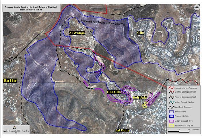
Israel heedlessness of the international community and the United Nations Security Council resolutions has hit a new record as a private initiative made by the Israeli Municipality of Jerusalem (status unrecognized) to illegally build a new Israeli settlement block on 2000 Dunums (according to Israeli sources) of agricultural lands that belong to Al-Walaja, Battir and Beit Jala residents. The Israeli colonization project that will hold the name of ''Givat Yael'' is set to include 13,500 housing units and accommodates more than 55,000 Israeli settlers. See map
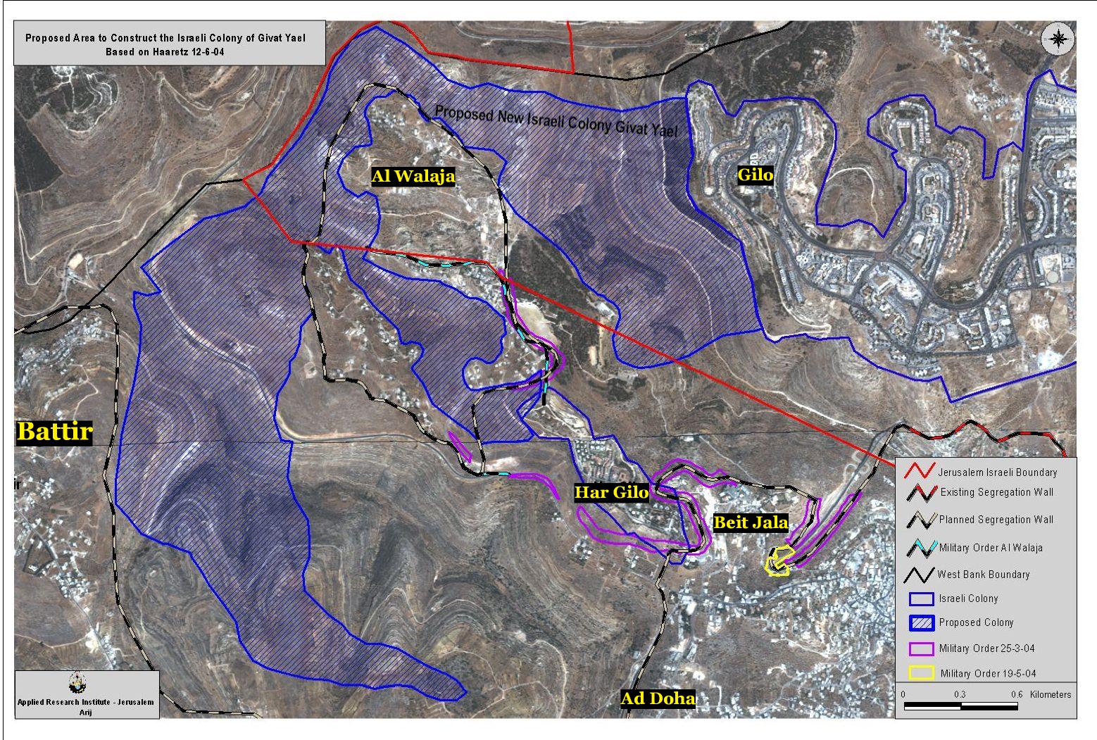
According to the Applied Research Institute (ARIJ) data, the total land area threatened to be confiscated to construct this colonization project is 4.111 Km2 (4111 dunums); out of which, 1.766 Km2 (1766 dunums) are located within Jerusalem illegal boundaries and 2.345 Km2 (2345 dunums) from Beit Jala, Battir & Al-Walaja lands. Prior to this initiative, the threatened area was classified as ''Green Lands'' and was off limits to the Palestinian residents. The Israeli occupation authorities has constantly prohibited the Palestinian land owners to build on their land, and for decades, denied their right in shelter. Furthermore, the Israeli Jerusalem Municipality is even coordinating with the Israeli Defense Ministry to reroute the Segregation Wall, which is set to tear Al-Walaja apart in order to include a larger area from the Occupied Territories on the other side of the wall and annex it to Israel.
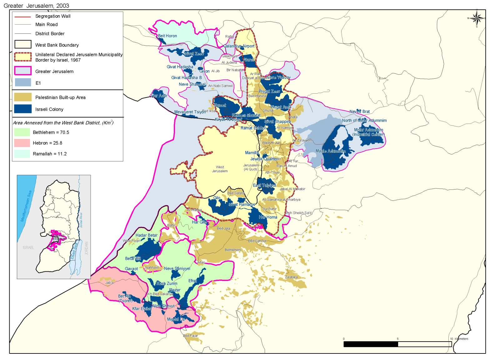
The new initiative intends to create an Israeli settlements chain between Jerusalem and Gush Etzion settlements bloc (southwest of Bethlehem district) as a part of the ''Jerusalem Envelope'' plan to encompass as much land as possible and to increase the number of Israelis within Jerusalem illegal boundaries to create facts on the ground to alter the demographic status of the city and influence the outcome of future negotiations regarding Jerusalem as stated by Jerusalem Deputy Mayor Yehoshua Polak ('We want as many Jews as possible in Jerusalem to influence the demographic situation'). See map of Jerusalem Envelope
However, both, the Israeli Interior Ministry and the Israeli Land Administration claimed that the targeted lands were privately purchased by ''Himnuta Ltd'', a facade of the Jewish National Fund, who is acting individually and not on behalf of the State of Israel. The reality remains constant regardless of the party responsible for the initiative to develop the new project despite the fact that landowners of the targeted areas, Al-Walaja, Beit Jala, and Battir hold all the legal documents to prove their ownership of the lands.
The new Israeli ''South Jerusalem'' constitute an explicit violation of the international law, UN Resolutions, and the Fourth Geneva Convention of 1949 in addition to the Oslo Peace Accords which dictates that non of the conflicted parties are to engage in any measure that might influence the outcome of the final issues of negotiations.
Related Case Studies
1. A New Confiscation Order for the Segregation Wall in Beit Jala, June 10, 2004
2. Walling In the Bethlehem Ghetto: Beit Jala Land Seizure, April 21, 2004.
3. The Segregation Wall: A skyline in Beit Jala, April 7, 2004
4. Fencing Beit Jala, October 28,2003
Prepared by:
The Applied Research Institute – Jerusalem