• About The Project
  • Palestine in Century
  • Selected Maps
  • Glossary
  • About ARIJ
  • About LRC
  • By Year
    • Case Studies By Year
    • Daily Report By Year
Wednesday, November 5, 2025
POICA
No Result
View All Result
  • Home
  • Settlements
    • New Israeli Settlements
    • Settlement Expansion
  • Israeli Violations
    • Agriculture
    • Confiscation
    • Demolition
    • Environment
    • Eviction of Palestinians
    • Settlers Attacks
  • Bypass Roads
  • Israeli Plans
  • Segregation
    • Checkpoints
    • Closure
    • Separation Plans
  • Military Orders
  • Reports
    • Daily Report
    • Monthly Report
    • Quarterly Report
No Result
View All Result
POICA
No Result
View All Result

Khallet Hamameh: another expansion of Jerusalem municipality boundaries

June 3, 2004
in Israeli Plans
Khallet Hamameh: another expansion of Jerusalem municipality boundaries

Expanding the municipality borders of Jerusalem city is one of the goals Jerusalem Israelization. Today, through the implementation of the Segregation Wall, Israel is annexing as much land as possible from the West Bank, mainly to expand the Israeli municipality borders of Jerusalem. Vast areas of East Jerusalem were unilaterally annexed after the 1967 war, and many areas were declared as part of Jerusalem while they belong originally to Bethlehem and Ramallah districts, Khallet Hamameh near Beit Jala adjacent to Ayda camp along with Al Nu'man and al Walaja villages is a clear example.


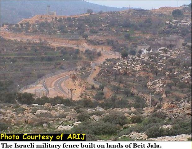
Khallet Hamameh, an area located between Ayda refugee camp and Beit Jala, it was declared as part of Jerusalem municipality borders after the annexation of East Jerusalem, but not all residents were considered as Jerusalemites. Today, the Segregation Wall is being built along the illegally expanded boundaries declared by Israel after the year 1967 and Palestinian residents are facing the threat of being considered as 'illegal dwellers' in their lands and homes. See pictures of the Segregation Wall constructed on Lands of Beit Jala.


Photo 1, Photo 2 & Photo 3

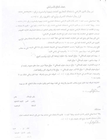
I'miah, a Palestinian family, is one of the cases facing the threat of loosing its land. The family has documents that prove its ownership of the land. See Doc 1 & Doc 2


I'miah's property includes an old house built in the heart of a five dunums land. See photo 4 & Photo 5


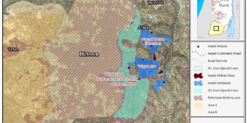
In 1995, the Israeli authorities decided to confiscate one-dunum of land from I'maih's land for building the Israeli bypass road # 60. (See maps). I'maih family has been paying the Israeli property tax 'Arnona' for the Jerusalem municipality; besides, water and electricity services have been facilitated by the Israeli ministry of infrastructure. See Doc 3, Doc 4 & Doc 5


The Israeli authorities are not willing to recognize the family as the legal owner of the land even though the family has all the necessary documents that proof its ownership of the land. The family pursued the case in Jerusalem municipality court and only succeeded to get a decision from the legal adviser of the Israeli army to issue permits for the family members in case of security, to enter the state of Israel. See permit


The family later received Israeli orders to displace the land and was prohibited from entering Jerusalem. The policy of constructing the Segregation Wall in the occupied territories is bringing many facts on the ground by the Israeli government, which in turn, deprives Palestinians from living in East Jerusalem, and pre-empting the Palestinians of 1967 borders, leaving no applicability to the right of return.

Related articles:-

  • The Segregation Wall: A skyline in Beit Jala, April 7, 2004
     
  • Walling in the Bethlehem Ghetto: Beit Jala Land Seizure, April 21, 2004


Prepared by:
The Applied Research Institute – Jerusalem


Recommended For You

الدورة الشتوية للكنيست الإسرائيلي 2025: الضم كسلاح سياسي وإقليمي

by arij
October 25, 2025
0

افتتحت الدورة الشتوية للكنيست الإسرائيلي وسط تصاعد التوترات، وتميزت بهجوم حاد من الحكومة على القضاء. في كلمته الافتتاحية، انتقد رئيس الوزراء بنيامين نتنياهو القضاء مباشرة ودافع عن العمليات...

Read moreDetails

The Israeli Knesset Winter Session 2025: Annexation as a Political and Territorial Weapon

by arij
October 25, 2025
0

Executive Summary The winter session of Israel’s Knesset opened amidst heightened tensions, marked by a sharp government attack on the judiciary. Prime Minister Benjamin Netanyahu, in his opening...

Read moreDetails

منطقة (H2): المساعي الاستيطانية لإسرائيل في تشكيل جغرافيا وديموغرافيا مدينة الخليل التاريخية

by arij
November 3, 2025
0
Israeli Breach of the Hebron Agreement through the Establishment of a New Settlement in Area (H1)

 الوضع الجيوسياسي وديمغرافيا منطقة (H2) في مدينة الخليل  تعد مدينة الخليل واحدة من أقدم المدن الفلسطينية المأهولة وأكثرها أهمية دينية واقتصادية وسياسية في الضفة الغربية، إذ تقع في...

Read moreDetails

الرئاسة الثانية لترامب: فرصة متجددة لطموحات إسرائيل التوسعية – ضم غور الأردن والتداعيات على حل الدولتين واستقرار المنطقة

by arij
October 14, 2025
0
Annexation of the Jordan Valley: Implications for the Two-State Solution and Regional Stability

تجددت مساعي وطموحات إسرائيل لضم غور الأردن، مع فترة الرئاسة الثانية للرئيس الأمريكي دونالد ترامب وبتأييد من ائتلاف رئيس الوزراء بنيامين نتنياهو اليميني المتطرف، والتي أصبحت نقطة تحول...

Read moreDetails

محافظة أريحا على خريطة المصادرة الإسرائيلية- إسرائيل تسعى للاستحواذ على أكثر من 7000 دونم في منطقة النبي موسى

by arij
October 13, 2025
0
محافظة أريحا على خريطة المصادرة الإسرائيلية- إسرائيل تسعى للاستحواذ على أكثر من 7000 دونم في منطقة النبي موسى

في العاشر من شهر أيلول من العام 2025، نشرت ما تُسمّى "بدائرة أراضي إسرائيل" ستة إعلانات جديدة مفادها بأن ما يُعرف بـ*"المسؤول عن أملاك الحكومة"* في الضفة الغربية...

Read moreDetails
Next Post
A new type of Land annexation

A new type of Land annexation

LATEST NEWS

“ما يزيد عن 25 ألف دونم من أراض الزيتون”,
موسم الزيتون في فلسطين تحت رهن الأوامر العسكرية

by arij
November 3, 2025
0

........................................................

From conflict Resolution to Conflict Management

حول تسجيل الأراضي في مناطق “ج”: سياسة سموتريتش لتمكين السيطرة الإسرائيلية على الأراضي الفلسطينية

by arij
November 3, 2025
0

........................................................

الدورة الشتوية للكنيست الإسرائيلي 2025: الضم كسلاح سياسي وإقليمي

by arij
October 25, 2025
0

........................................................

The Israeli Knesset Winter Session 2025: Annexation as a Political and Territorial Weapon

by arij
October 25, 2025
0

........................................................

flag_yellow_lowEU-PfP-Logo

This website and its content were initiated in 1993 by the Applied Research Institute – Jerusalem (ARIJ) and the Land Research Center (LRC) with the support from the European Union up until 2023. Since then, the Applied Research Institute – Jerusalem (ARIJ) has taken over the continued development and maintenance of the website. The views expressed remain solely those of ARIJ) and do not necessarily reflect those of the European Union.

© 2025 Copyright ARIJ . All Rights reserved. .

No Result
View All Result
  • Home
  • Settlements
    • New Israeli Settlements
    • Settlement Expansion
  • Israeli Violations
    • Agriculture
    • Confiscation
    • Demolition
    • Environment
    • Eviction of Palestinians
    • Settlers Attacks
  • Bypass Roads
  • Israeli Plans
  • Segregation
    • Checkpoints
    • Closure
    • Separation Plans
  • Military Orders
  • Reports
    • Daily Report
    • Monthly Report
    • Quarterly Report

© 2025 Copyright ARIJ . All Rights reserved. .