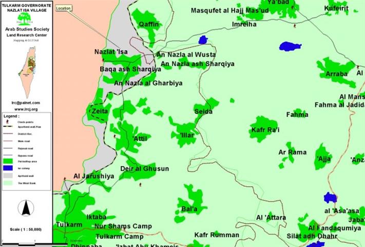
Location and Population
The village of Nazlat Isa, which borders the Green Line, is located 18 kilometers to the north of the city of Tulkarem. Its population in 1967 was about 1200 Palestinians and it reached about 2500 according to the 2003 projections. All of the residents of the village belong to one big family called Al Hussein which includes a number of sub-clans such as the Daoud, Shawareb, Suleiman, Mis'ed, Sawalha, Abdel Al Rahman and Aloushi families. See Map of Location
As for the sources of income of the population, 97 % of the residents used to rely on agriculture and sheep before the year 1967. The remaining 3% used to rely on official and governmental jobs. Since 1967 and until the beginning of 1996 a large segment of the population shifted from being farmers to work as laborers in the Israeli market as well as working in commerce.
The village Area
Before the 1948 war, the total area associated with the village was about 12,400 dunums, 10,000 of which were seized by the Israelis during the war. The remaining 2,400 mountainous dunums were classified as follows:
-
800 dunums reserved for housing purposes
-
230 dunums planted with citrus trees.
-
26 dunums used for plants grown in plastic homes.
-
The remaining dunums were planted with olive trees.
The Village and the Segregation Wall
During the year 2003 the village came under a vicious Israeli campaign to control its lands for the purpose of building the Israeli segregation Wall. More than 300 dunums were confiscated and about 1990 olive trees were uprooted as a prelude for the erection of the Wall. Moreover, more than 524 dunums were squeezed between the Wall and the Green line which led to the deprivation of Palestinian farmers from reaching it leading to the de facto confiscation of 9965 olive trees. Such a fact is a strong evidence that the mere concept of the Wall is virtually a plan to force a new Palestinian migration wave as it confiscates 58% of Palestinian lands occupied in 1967, 80% of Palestinian underground water in addition to 85% of Palestinian fertile lands. That is not to mention the isolation of cities and villages in an attempt to transfer them into cantons and easily controlled and contained jails. See photo 2

The village of Nazlat Isa is a clear example of the effects and makeup of the Wall; two walls surrounding the village from all directions were built. The first wall separates between the village and the Green Line, while, the second wall separates between the village and its surrounding Palestinian communities. This second wall was removed by Israeli forces as to appear in front of the international public opinion as a propaganda especially if taken into consideration that such a move took place on the first day of the Hague Hearings about the legality of the Wall vis-a-vie international law in March 2004.
General Description of the Wall in Nazlat Isa
The total length of the Wall in Nazlat Isa is about 3-5 kilometers distributed as follows:
-
Concrete blocks 8 meters high and 1 kilometer in length.
-
A number of metal barriers 2.5 kilometers in length and a width of about 40 to 65 meters. Such barriers include:
1. Barbed wires
2. Trenches
3. Electrocution wires + early warning network
4. Track checking area
5. Street
6. Ditch
7. Barbed wires
It's worth mentioning here that the cost of the Wall is 1 million shekels per kilometer.
The Impact of the Wall on Nazlat Isa
1) Social Impact:
-
It led to the separation of 70 to 80 families on both sides of the Green Line as residents of Nazlat Isa will not be allowed to visit their relatives in the nearby Baqa' Al Gharbiya village located in side the Green Line.
-
The separation of 7 houses in the village from the rest of the village as they were left behind the Wall. Israeli occupation forces issued special permits for the residents of these houses to enable them to go through the only gate in the Wall. Yet, it has been the case that these forces won't abide by such permits and that the gate would be closed down for long intervals of time which would lead to severing the ties between these families and the mother village. Moreover, Israeli occupation forces issued a ruling preventing these isolated families from the right of ownership in that region.
Following a firm policy of opening fire on anybody who gets close to the Wall.
2) Economical Impact:
The erection of the Wall caused a major economical loss as it led to the following:
The demolition of 180 commercial stores in the market of the village in September 2003. By doing so, Israeli forces destroyed the income source of about 12,000 families that used to work and / or benefit from this market from the village and surrounding areas. These forces, also, transformed 97% of the residents of the village into unemployed as well as destroying commercial life in the village. See photo 3
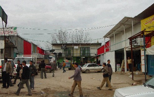
Photo 3: The market before destruction, Photo courtesy of LRC
The destruction of 10 dunums of plastic houses in addition to plowing 90 dunums filled with citrus trees. See Photo 4
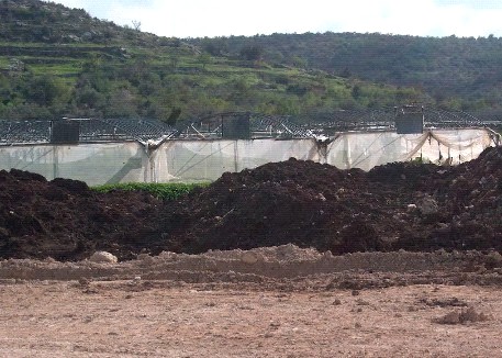
Photo 4: Nazlat Isa- Tulkarem: plastic houses destroyed for Wall construction, Photo courtesy of LRC
The emerging of difficulties in marketing agricultural produce inside the Green Line which used to constitutes a major marketing venue for Palestinian farmers. Examples of such farmers include:
- Mr. Ahmad Mohammed Abu Mukh who is a resident of the village, married, and has 6 children. He was severely affected by the Wall through the confiscation of the 31 dunums he used to own as well as the destruction of his 2 stores. Now he is unemployed with no property to his name.
- Mr. Mohammed Abdel Khaleq Hussein. He was a farmer who depended on his citrus trees as well as his plastic house for income. The Wall devoured both leaving him as a helpless and hopeless poor man.
3) Environmental Impact:
The uprooting of 1990 olive trees and the transformation of fertile lands into sheep vegetation areas as Israeli forces gave permits only to sheep owners (vs. farmers) to use the area as to assure its destruction. See Photo 5
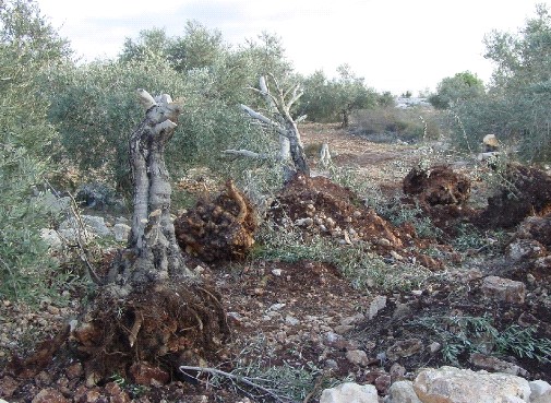
Photo 5: Nazlat Isa- Tulkarem: Palestinian olive trees are uprooted and taken
away by Israeli authorities for re-plantation in settlements, Photo courtesy of LRC.
Prepared by
The Land Research Center
LRC


