• About The Project
  • Palestine in Century
  • Selected Maps
  • Glossary
  • About ARIJ
  • About LRC
  • By Year
    • Case Studies By Year
    • Daily Report By Year
Monday, October 13, 2025
POICA
No Result
View All Result
  • Home
  • Settlements
    • New Israeli Settlements
    • Settlement Expansion
  • Israeli Violations
    • Agriculture
    • Confiscation
    • Demolition
    • Environment
    • Eviction of Palestinians
    • Settlers Attacks
  • Bypass Roads
  • Israeli Plans
  • Segregation
    • Checkpoints
    • Closure
    • Separation Plans
  • Military Orders
  • Reports
    • Daily Report
    • Monthly Report
    • Quarterly Report
No Result
View All Result
POICA
No Result
View All Result

Abu Dis: A Palestinian Town Tarred by the Israeli Wall

February 4, 2004
in Segregation
Abu Dis:  A Palestinian Town Tarred by the Israeli Wall


To the southeast of Jerusalem is where the Palestinian Town Abu Dis is located, a home for more than 11,500 Palestinians and a vital center to several surrounding Palestinian communities:

  • Al-Sawahereh Al-Sharqieh & Al-Gharbieh. Population: 4,910 residents.
  • Ash-Sheikh Sa'd. Population: 2,267 residents.
  • Al-Eizariya. Population: 16,395 residents 

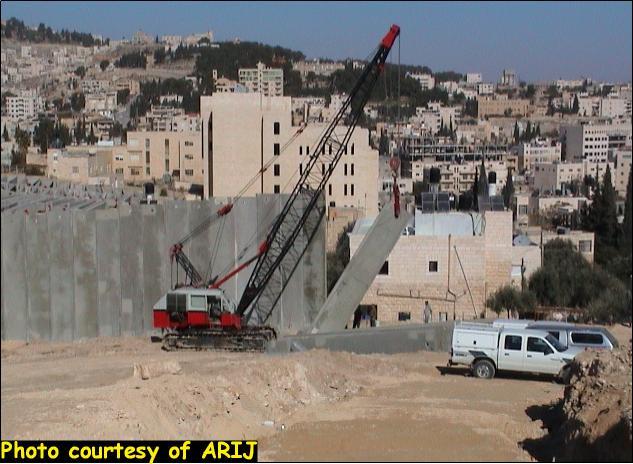
  In late December 2003, the Israeli government commenced stage two of the Segregation Wall in Abu Dis area, which aims to besiege the town from its northeastern and northwestern boundaries. The town will fall under siege soon enough as the work to put up the Wall continues around the clock.  See Photo 1

 
Rigging-up the 8 meters (27 feet) cement partitions just few meters away from the Palestinian Legislative Council (PLC) located in the heart of Abu Dis. The Wall route continues to disrupt the town of Abu Dis and the Palestinian families living in it. See Photo 2

The Israeli so-called ''Security Wall'' created tangible segregated zone within the town as families living 3 meters (10 feet) apart are incapable of communicating with one another. The Wall even resulted in blocking out the daylight from these houses. Some houses among others received demolition orders from the Israeli Army. The Israeli army officer advised the house-owners to take-up the matter with the Israeli Jerusalem Municipality, but the Municipality in its turn offered to buy the houses from the Palestinian residents. Naturally, the house-owners refused to sell and submitted a petition to the Israeli court to avert the demolition order. See Photo 3 & Photo 4


Ras Qubsih is an area located at the northwestern border of Abu Dis and an entrance to Jerusalem city. Some 15 months earlier, the Israeli Army blocked the entrance with 4 meters (14 feet) cement partitions to prevent the people from entering Jerusalem. Abu Dis residents, the surrounding communities in addition to the West Bank residents were denied entrance to Jerusalem as the only cross point designated for that purpose was all-time guarded by the Israeli Army. Click here for more information
 
During the latest Israeli activities in that area, the 4 meters cement partitions where substituted with the new 8 meters partitions, making sure all accesses to Jerusalem are completely sealed. The great majority of residents in Abu Dis and the surrounding communities are holders of the Israeli Identification cards (blue ID) which entitle them free access to Jerusalem. By segregating Abu-Dis into two entities, a break down of social structure in addition to other life aspects: economy, health, educational ..etc expected to manifest. The surrounding communities will suffer no less damage, if not worse, as the residents' will be cut off from Abu Dis town and Jerusalem city at the same time.  

Abu Dis has an area of 28,232 Dunums (11,293 Acers). The Segregation Wall will detach some 6000 Dunums of agricultural land in that area and cost the residents of the community the loss of a considerable share of their income. See Photo 5

 
Another parts of the segregated area in Abu Dis designated for the towns future expansion, the lack of such areas will lead to voluntary migration of Abu Dis residents to other areas, possibly on the outskirts of Jerusalem where they might be at risk of losing residential privileges. See Photo 6


At the early Israeli work on the Segregation Wall, land properties of several monasterial lands ''Der Almahaba'', ''Der Gargoury' and ''Der Beit Fajey'' in Al-Eizariya where violated, for more information, click here.
 
Recently, while rigging-up the Wall in Abu Dis archeological burials where excavated near Abu Dis University. The Israeli Archeology Administration claimed the excavated burials and restricted entrance to the area only to authorized personnel after enclosing the site (where the burials found) with 8 meters cement partitions and resumed the excavation unilaterally without disclosing any information regarding the discoveries with the Palestinian Archeology Administration. 
   
Abu Dis is an example of many Palestinian areas victimized by the Israel actions and the Segregation Wall.

The Israeli activities in the Palestinian territories have surpassed illegality long ago as it violated countless international laws including the Forth Geneva Convention of 1949 and United Nations Resolutions. Furthermore, the Israeli heedlessness to the United Nations and the Security Council's decisions must not go with impunity.   More pictures of the Wall in Abu Dis city


The Segregation Wall in Abu Dis city


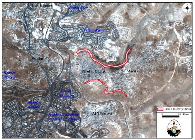
The track of the Wall in Abu Dis city


 The Wall in Pictures 


The Segregation Wall and the Palestinian living


Prepared by:
The Applied Research Institute – Jerusalem


Recommended For You

عقاب جماعي يومي: الفلسطينيون تحت هيمنة الحواجز العسكرية

by arij
September 24, 2025
0
عقاب جماعي يومي: الفلسطينيون تحت هيمنة الحواجز العسكرية

تشهد الضفة الغربية المحتلة واقعًا خانقًا نتيجة السياسات الإسرائيلية المتمثلة بفرض المزيد من الحواجز العسكرية اليومية والإغلاقات، والتي باتت أداة منهجية للسيطرة والتحكم بحياة الفلسطينيين اليومية، وليست مجرد...

Read moreDetails

العدالة المؤجلة ورأي بلا تنفيذ: من قرار المحكمة إلى واقع الضم

by arij
July 9, 2025
0
العدالة المؤجلة ورأي بلا تنفيذ: من قرار المحكمة إلى واقع الضم

مقدمة في التاسع من تموز 2004، أصدرت محكمة العدل الدولية، وهي الجهاز القضائي الرئيسي للأمم المتحدة، رأيا استشاريا تاريخيا اعتبرت فيه بناء اسرائيل لجدار الفصل في الاراضي الفلسطينية...

Read moreDetails

سلطات الاحتلال الإسرائيلي تفرض واقعا جيوسياسيا جديدا في منطقة شمال قطاع غزة المحتل

by arij
March 13, 2024
0
سلطات الاحتلال الإسرائيلي تفرض واقعا جيوسياسيا جديدا في منطقة شمال قطاع غزة المحتل

  أظهرت صور الأقمار الصناعية الصادرة عن برنامج مراقبة الأرض التابع للاتحاد الأوروبي (كوبرنيكوس) لقطاع غزة المحتل في العاشر من شهر اذار من العام 2024، ان سلطات الاحتلال...

Read moreDetails

الحرب على قطاع غزة وتأثيرها على محافظة الخليل جنوب الضفة الغربية

by arij
November 30, 2023
0

  تقع محافظة الخليل في الجزء الجنوبي من الضفة الغربية المحتلة، إلى الجنوب من مدينة القدس، وعلى بعد حوالي 36 كم منها. يحدها من الشمال محافظة بيت لحم،...

Read moreDetails

تطبيق سياسة الفصل العنصري على استخدام الطرق الرئيسية في الضفة الغربية وتقيد حركة وتنقل المواطنين الفلسطينيين

by arij
November 22, 2023
0
معاناة شجرة الزيتون الفلسطينية بسبب الاحتلال والاستيطان في العام 2023

  بناء على تقديرات مراقبين دوليين يبلغ عدد الحواجز الإسرائيلية في الضفة الغربية أكثر من 567 حاجز إسرائيلي متعددة الاشكال منها 77 حاجزًا رئيسيًا وجزئي تتحكم في حركة...

Read moreDetails
Next Post
The Wall strangulates ‘Anata and cuts off Shu’fat camp

The Wall strangulates 'Anata and cuts off Shu'fat camp

LATEST NEWS

محافظة أريحا على خريطة المصادرة الإسرائيلية- إسرائيل تسعى للاستحواذ على أكثر من 7000 دونم في منطقة النبي موسى

محافظة أريحا على خريطة المصادرة الإسرائيلية- إسرائيل تسعى للاستحواذ على أكثر من 7000 دونم في منطقة النبي موسى

by arij
October 9, 2025
0

........................................................

ما يزيد عن 1900 دونما من الأراضي الفلسطينية في بيت لحم مهددة بالعزل لصالح مستوطنة افراتا

ما يزيد عن 1900 دونما من الأراضي الفلسطينية في بيت لحم مهددة بالعزل لصالح مستوطنة افراتا

by arij
October 8, 2025
0

........................................................

Annexation of the Jordan Valley: Implications for the Two-State Solution and Regional Stability

Annexation of the Jordan Valley: Implications for the Two-State Solution and Regional Stability

by arij
September 29, 2025
0

........................................................

Isolation of Three Villages Northwest of Jerusalem: Silent Annexation Creeps toward the Capital

عزل ثلاث قرى فلسطينية شمال غرب مدينة القدس: الضم الاسرائيلي الصامت يزحف نحو محيط العاصمة

by arij
September 24, 2025
0

........................................................

flag_yellow_lowEU-PfP-Logo

This website and its content were initiated in 1993 by the Applied Research Institute – Jerusalem (ARIJ) and the Land Research Center (LRC) with the support from the European Union up until 2023. Since then, the Applied Research Institute – Jerusalem (ARIJ) has taken over the continued development and maintenance of the website. The views expressed remain solely those of ARIJ) and do not necessarily reflect those of the European Union.

© 2025 Copyright ARIJ . All Rights reserved. .

No Result
View All Result
  • Home
  • Settlements
    • New Israeli Settlements
    • Settlement Expansion
  • Israeli Violations
    • Agriculture
    • Confiscation
    • Demolition
    • Environment
    • Eviction of Palestinians
    • Settlers Attacks
  • Bypass Roads
  • Israeli Plans
  • Segregation
    • Checkpoints
    • Closure
    • Separation Plans
  • Military Orders
  • Reports
    • Daily Report
    • Monthly Report
    • Quarterly Report

© 2025 Copyright ARIJ . All Rights reserved. .