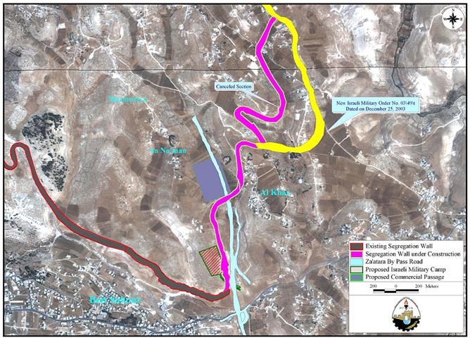
On December 25, 2003, the Israeli Offense Army (IOA) issued a seize order # 03/49T (Judea & Samaria) 2003 ''effective immediately''. The order relocates the route of the Segregation Wall in Al-Khas village east of Beit Sahour in Bethlehem District and in Sur Baher southeast Jerusalem District. See map of military order and Photo 1, Photo 2 & Photo 3
The core of the order validates shifting the route of the Segregation Wall eastward in comparison with the originally approved and declared one. The new shift under the stated order will cost the residents of Al-Khas and Sur Baher an additional 541 Dunums (134 Acers) of which 446 Dunums are agricultural lands while the remaining 95 Dunums are built-up area. The new amendment will include more than 40 Palestinian residences that accommodate more than 200 Palestinians. See Photo 4 & Photo 5..
Following is a translation of the designated order:
|
Military Order's Translation Israel Defense Forces: Order to Seize lands # 03/49/T (Border Amendment)
According to my authorities as a Military Chief Commander in the Region of Judea and Samaria, and as I believe that it is imperative for military purposes due to the special security situation in the region, I order the following:
ITEMS
1. With regard to:
The Mapissigned with a scale of 1: 10.000 and attached to the order is an essential part of this order.
Sur Baher
Bethlehem
Land Seize
2. I declare by that the above-mentioned lands seized for military purposes.
Land Seize Cancellation
3. I declare land seized marked yellow in the map are cancelled.
Possession
4. The Israeli Defense Army declares absolute possession of stated lands and authorizes it to the land officer at the central command headquarters under the Ministry of Defense.
Issuance
5. Copies of the order at hand are to be delivered to the District Coordination Office (DCO) in Bethlehem who will in its turn pass the order on to the landowners.
Allocation
6. Copies of the order at hand along with the attached map are to be located at the following places for public reference:
Land Usage & Compensation Inquiries
7. For inquiries regarding land usage and compensations, the landowners are to contact the District Coordination Office (DCO) in Bethlehem.
Order Effect
8. The order will go in effect at the time of its signing to December 31,2005.
Identify
9. The order at hand will be identified as ''Land Seize Order # 03/49/T (Judea and Samaria) 2003''.
Mosheh Kaplenski
|
The Israeli seize order is only identifying the new route of the Segregation Wall as the seized lands (122.2 Dunums) while the fact is that the area to be grabbed from the Palestinian territories and to be included within the Wall is 541 Dunums. The targeted area (541 Dunums) is situated between Bethlehem district (390 Dunums-96 Acre) and Jerusalem district (151 Dunums-38 Acre). The targeted land (541 Dunums) is categorized in accordance with the ''Oslo II'' agreement of September 28, 1995 (Areas A, B, and C), which designates varying levels of control. The map below illustrates the areas confiscated as in the table that follows:
|
||||||||||||||||||||||
Table 1 show that more than 156 Dunums of Palestinian land are located in Area A, which is under full Palestinian control, it means that Israel is clearly violating the agreements signed with the Palestinians during the peace negotiations. See Photo 6 & Photo 7
The significance of the order lays in its title (Border Amendment), even though, the Israeli PM Ariel Sharon along with a various government officials repeatedly stated and emphasized that the Wall is not a border. On the other hand, the IOF clearly defines the order of the Segregation Wall as a Border between Israel and the areas under Palestinian jurisdiction. Accordingly, Israel is executing the Segregation Wall with all the amendments it sees fit and constituting consequently a border that guarantee the Israeli vision to annex nearly 60% of the West Bank.
Prepared by:
The Applied Research Institute – Jerusalem


