• About The Project
  • Palestine in Century
  • Selected Maps
  • Glossary
  • About ARIJ
  • About LRC
  • By Year
    • Case Studies By Year
    • Daily Report By Year
Wednesday, June 4, 2025
POICA
No Result
View All Result
  • Home
  • Settlements
    • New Israeli Settlements
    • Settlement Expansion
  • Israeli Violations
    • Agriculture
    • Confiscation
    • Demolition
    • Environment
    • Eviction of Palestinians
    • Settlers Attacks
  • Bypass Roads
  • Israeli Plans
  • Segregation
    • Checkpoints
    • Closure
    • Separation Plans
  • Military Orders
  • Reports
    • Daily Report
    • Monthly Report
    • Quarterly Report
No Result
View All Result
POICA
No Result
View All Result

Segregating Rantis village lands

December 2, 2003
in Segregation
Segregating Rantis village lands

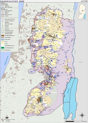
On the 23 June 2002, the Israeli government endorsed a plan to build the so-called 'Security wall' running into the full length of the west bank, and is expected to be completed by year 2005. Based on ARIJ satellite images, this Segregation Wall has already annexed vast areas of Palestinian agricultural lands containing approximately 57 Israeli settlements inhabited by almost 300,000 Israeli settlers. About (385.000) Palestinians will be effectively isolated and most of the West Bank's fertile lands are under the threat of confiscation. See Map of the Segregation Wall.


Rantis village, to the northwest of Ramallah district, is a typical example of the Israeli violations in the West Bank where most of its lands will be confiscated for the construction of the Segregation Wall. The village is inhabited by approximately 2500 residents most of whom depend on agriculture as their main source of income.  


In 1967 the Israeli forces confiscated most of the agricultural lands in the village for colonizing purposes and hundreds of olive trees were razed. Now the village of Rantis is surrounded by a set of settlements and military areas, of which Ofrim Settlement lies to the east of the village and a military area lies to the northwest of the village.  See Map of Rantis Village.


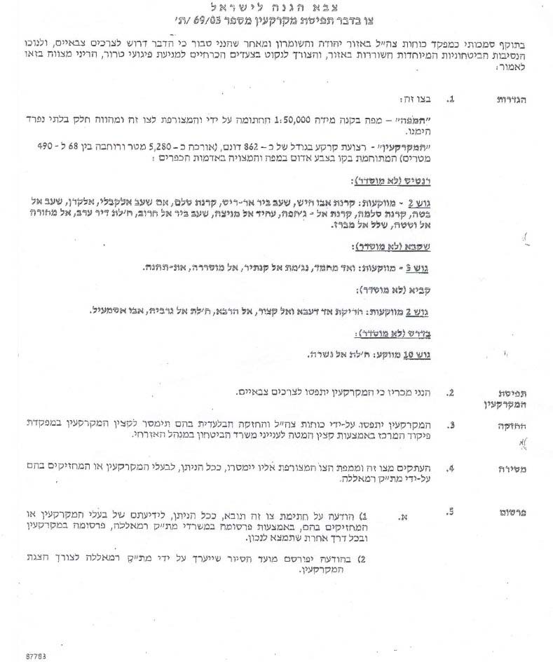
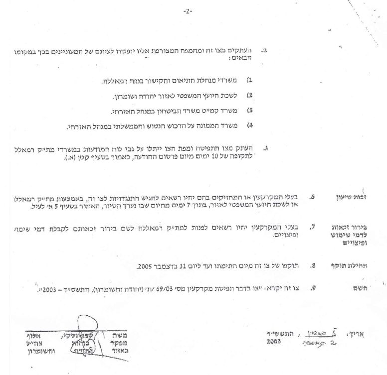
Currently, the Segregation Wall will cause the confiscation of about 680 dunums of Rantis village. The Israeli forces informed the villagers that 862 dunums of their agricultural lands will be confiscated for the construction of the Segregation Wall according to the military order number (03/69/T Judea & Samaria 2003) that was distributed late in October and stated the annexation of those lands for military purposes and security reasons. The order shows the blocks and parcels of land to be confiscated. See copy of military order. Page 1 & & Page 2 of the military order.


 This confiscation of the land will severely affect the village of Rantis where most of its lands are cultivated by olive trees; thus, a huge number of olive trees will be razed. The planned Segregation Wall will steal the village's lands and seal off the city from its agricultural lands. Most of the farmers depend totally on agricultural productions as a main source for their income. Now villagers will not be able to enter their farms and agricultural lands and therefore will have to search for alternative ways to earn a living which will increase the unemployment rate and hence increase poverty levels.

Another important impact forces Palestinians to apply for special permits to enter their farms as the Israelis announcing the areas as closed military areas and thus, people with permits are only allowed to access their lands.

 The confiscation of the land for the construction of the Segregation Wall is considered an illegal annexation as Israel is seeking to acquire this part of the Palestinian territory to include it in Israel.


Prepared by:
The Applied Research Institute – Jerusalem


Recommended For You

سلطات الاحتلال الإسرائيلي تفرض واقعا جيوسياسيا جديدا في منطقة شمال قطاع غزة المحتل

by arij
March 13, 2024
0
سلطات الاحتلال الإسرائيلي تفرض واقعا جيوسياسيا جديدا في منطقة شمال قطاع غزة المحتل

  أظهرت صور الأقمار الصناعية الصادرة عن برنامج مراقبة الأرض التابع للاتحاد الأوروبي (كوبرنيكوس) لقطاع غزة المحتل في العاشر من شهر اذار من العام 2024، ان سلطات الاحتلال...

Read moreDetails

الحرب على قطاع غزة وتأثيرها على محافظة الخليل جنوب الضفة الغربية

by arij
November 30, 2023
0

  تقع محافظة الخليل في الجزء الجنوبي من الضفة الغربية المحتلة، إلى الجنوب من مدينة القدس، وعلى بعد حوالي 36 كم منها. يحدها من الشمال محافظة بيت لحم،...

Read moreDetails

تطبيق سياسة الفصل العنصري على استخدام الطرق الرئيسية في الضفة الغربية وتقيد حركة وتنقل المواطنين الفلسطينيين

by arij
November 22, 2023
0
معاناة شجرة الزيتون الفلسطينية بسبب الاحتلال والاستيطان في العام 2023

  بناء على تقديرات مراقبين دوليين يبلغ عدد الحواجز الإسرائيلية في الضفة الغربية أكثر من 567 حاجز إسرائيلي متعددة الاشكال منها 77 حاجزًا رئيسيًا وجزئي تتحكم في حركة...

Read moreDetails

The Instigation of Apartheid Roads Era: Israel blocks Palestinian movement inside West Bank Governorates

by arij
November 22, 2023
0

  According to international observers, Israel constrains the West Bank territory with 567 various types of obstacles; 77 of which are main checkpoints and partial checkpoints that control...

Read moreDetails

Between “Ben Gavir” and Netanyahu Not Oblivious but Vindictive, The reality of Israeli Apartheid Stands in the occupied Palestinian territory

by arij
September 13, 2023
0
Between “Ben Gavir” and Netanyahu Not Oblivious but Vindictive, The reality of Israeli Apartheid Stands in the occupied Palestinian territory

  In the wake of the overwhelming Israeli settlers and the Israeli occupation government increasing their wave of attacks and assaults on the Palestinian people (more than 700...

Read moreDetails
Next Post
Reshaping the West Bank …New military orders in Tubas district

Reshaping the West Bank ...New military orders in Tubas district

LATEST NEWS

77 عام  على النكبة الفلسطينية: حاضر مستمر لا تاريخ منتهي

77 عام  على النكبة الفلسطينية: حاضر مستمر لا تاريخ منتهي

by arij
June 2, 2025
0

........................................................

Expansion of Gilo Settlement: A Strategic Plan to Isolate Bethlehem and Undermine Palestinian Rights

Expansion of Gilo Settlement: A Strategic Plan to Isolate Bethlehem and Undermine Palestinian Rights

by arij
May 12, 2025
0

........................................................

الأراضي الفلسطينية بين الذرائع الأمنية والأطماع الاستيطانية – “الأمن، الآثار، والطبيعة كحجج لاقتلاع الفلسطينيين من أراضيهم”

by arij
April 15, 2025
0

........................................................

الطرق الالتفافية الاسرائيلية وأثرها على البيئة الفلسطينية

انتهاك للطبيعة والهوية في الأراضي الفلسطينية المحتلة

by arij
March 17, 2025
0

........................................................

flag_yellow_lowEU-PfP-Logo

This website has been produced with the assistance of the European Union. The contents of this publication are the sole responsibility of ARIJ & LRC and can in no way be taken to reflect the views of the European Union.

© 2025 Copyright ARIJ . All Rights reserved. .

No Result
View All Result
  • Home
  • Settlements
    • New Israeli Settlements
    • Settlement Expansion
  • Israeli Violations
    • Agriculture
    • Confiscation
    • Demolition
    • Environment
    • Eviction of Palestinians
    • Settlers Attacks
  • Bypass Roads
  • Israeli Plans
  • Segregation
    • Checkpoints
    • Closure
    • Separation Plans
  • Military Orders
  • Reports
    • Daily Report
    • Monthly Report
    • Quarterly Report

© 2025 Copyright ARIJ . All Rights reserved. .