• About The Project
  • Palestine in Century
  • Selected Maps
  • Glossary
  • About ARIJ
  • About LRC
  • By Year
    • Case Studies By Year
    • Daily Report By Year
Sunday, October 12, 2025
POICA
No Result
View All Result
  • Home
  • Settlements
    • New Israeli Settlements
    • Settlement Expansion
  • Israeli Violations
    • Agriculture
    • Confiscation
    • Demolition
    • Environment
    • Eviction of Palestinians
    • Settlers Attacks
  • Bypass Roads
  • Israeli Plans
  • Segregation
    • Checkpoints
    • Closure
    • Separation Plans
  • Military Orders
  • Reports
    • Daily Report
    • Monthly Report
    • Quarterly Report
No Result
View All Result
POICA
No Result
View All Result

The effects of the Segregation Wall on the Palestinian village of Qaffin

August 10, 2003
in Segregation
The effects of the Segregation Wall on the Palestinian village of Qaffin


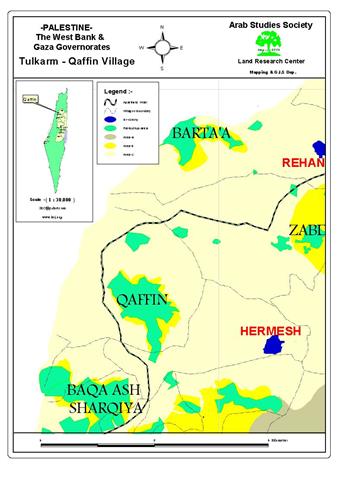
Governorate: Tulkarem

Village: Qaffin.

Location: it is located 20 km to north of the city of Tulkarem near the green line.( See Map)

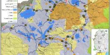
The map shows the boundaries of Qaffin village and the apartheid wall splitting its land and annexing almost half of its land to Israel proper.

Population: about 12 000 inhabitants live in the village.

Violation: the setting up of the apartheid wall in the land owned by the village inhabitants.

Date of commence of wall construction: August, 2002.

Method of informing owners: a written letter to the municipal council.

Stated reason for wall construction: security reasons.


Actual reasons from Palestinian point of view:

1.     Seize Palestinian land;

2.     Destroy the Palestinian agricultural infrastructure;

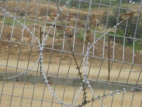
3.     Use pressures on Palestinians to force them leave their land. (See photo1)   


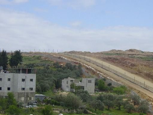
 Apartheid wall passing by Palestinian houses
Photo taken by LRC field worker


The village is situated 200 meters to the east of the wall. The wall travels about 6 kilometers in the village land from north to south. The wall has besieged about 4300 dunums of the village land. The body of the wall was built over an area of 627 dunums. The width of the wall varies from 100 to 110.

  • Number of uprooted Olive trees: 12545.

  • Number of isolated Olive trees: 81705.

  • The total area of the land owned by Qaffin inhabitants before the wall construction: 10000 dunums, including 18000 as master plan. 

  • Total area of land confiscated by the wall: 4027 dunums, which constitutes almost 50 % of the village land.

  • Previous violations against the village: In 1948, the village lost 20 000 dunums of its land during the war and as a result of the establishment of the state of Israel.

  • Number of farmers affected by the wall construction: 179.

A sketch of the wall composition:

The wall is comprised of the following components as seen in the picture below starting from right to left: 

1.     Barbed wires (three rows);

2.     Anti-car canal;

3.     Maintenance road;

4.     Electronic wall;

5.     Earth road to trace steps;

6.     Patrol road;

7.     Uneven surface;

8.     Drainage canal;

9.     Barbed wires ( three rows). (See photo2)  


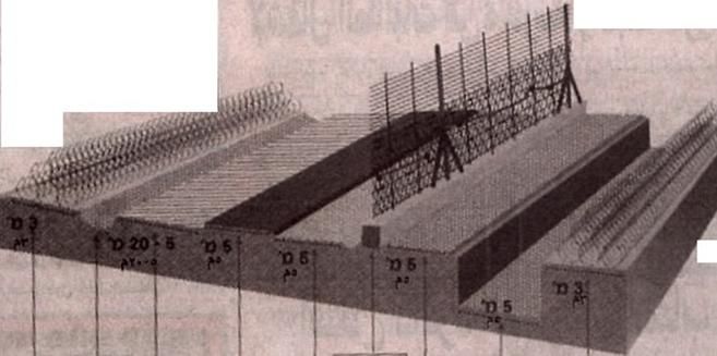
 Source: Israeli Ha'artz newspaper (9.5.2003).


Prepared by
The Land Research Center
LRC


Recommended For You

عقاب جماعي يومي: الفلسطينيون تحت هيمنة الحواجز العسكرية

by arij
September 24, 2025
0
عقاب جماعي يومي: الفلسطينيون تحت هيمنة الحواجز العسكرية

تشهد الضفة الغربية المحتلة واقعًا خانقًا نتيجة السياسات الإسرائيلية المتمثلة بفرض المزيد من الحواجز العسكرية اليومية والإغلاقات، والتي باتت أداة منهجية للسيطرة والتحكم بحياة الفلسطينيين اليومية، وليست مجرد...

Read moreDetails

العدالة المؤجلة ورأي بلا تنفيذ: من قرار المحكمة إلى واقع الضم

by arij
July 9, 2025
0
العدالة المؤجلة ورأي بلا تنفيذ: من قرار المحكمة إلى واقع الضم

مقدمة في التاسع من تموز 2004، أصدرت محكمة العدل الدولية، وهي الجهاز القضائي الرئيسي للأمم المتحدة، رأيا استشاريا تاريخيا اعتبرت فيه بناء اسرائيل لجدار الفصل في الاراضي الفلسطينية...

Read moreDetails

سلطات الاحتلال الإسرائيلي تفرض واقعا جيوسياسيا جديدا في منطقة شمال قطاع غزة المحتل

by arij
March 13, 2024
0
سلطات الاحتلال الإسرائيلي تفرض واقعا جيوسياسيا جديدا في منطقة شمال قطاع غزة المحتل

  أظهرت صور الأقمار الصناعية الصادرة عن برنامج مراقبة الأرض التابع للاتحاد الأوروبي (كوبرنيكوس) لقطاع غزة المحتل في العاشر من شهر اذار من العام 2024، ان سلطات الاحتلال...

Read moreDetails

الحرب على قطاع غزة وتأثيرها على محافظة الخليل جنوب الضفة الغربية

by arij
November 30, 2023
0

  تقع محافظة الخليل في الجزء الجنوبي من الضفة الغربية المحتلة، إلى الجنوب من مدينة القدس، وعلى بعد حوالي 36 كم منها. يحدها من الشمال محافظة بيت لحم،...

Read moreDetails

تطبيق سياسة الفصل العنصري على استخدام الطرق الرئيسية في الضفة الغربية وتقيد حركة وتنقل المواطنين الفلسطينيين

by arij
November 22, 2023
0
معاناة شجرة الزيتون الفلسطينية بسبب الاحتلال والاستيطان في العام 2023

  بناء على تقديرات مراقبين دوليين يبلغ عدد الحواجز الإسرائيلية في الضفة الغربية أكثر من 567 حاجز إسرائيلي متعددة الاشكال منها 77 حاجزًا رئيسيًا وجزئي تتحكم في حركة...

Read moreDetails
Next Post
Baqa Al Sharqia: A Palestinian village isolated by the Segregation Wall

Baqa Al Sharqia: A Palestinian village isolated by the Segregation Wall

LATEST NEWS

محافظة أريحا على خريطة المصادرة الإسرائيلية- إسرائيل تسعى للاستحواذ على أكثر من 7000 دونم في منطقة النبي موسى

محافظة أريحا على خريطة المصادرة الإسرائيلية- إسرائيل تسعى للاستحواذ على أكثر من 7000 دونم في منطقة النبي موسى

by arij
October 9, 2025
0

........................................................

ما يزيد عن 1900 دونما من الأراضي الفلسطينية في بيت لحم مهددة بالعزل لصالح مستوطنة افراتا

ما يزيد عن 1900 دونما من الأراضي الفلسطينية في بيت لحم مهددة بالعزل لصالح مستوطنة افراتا

by arij
October 8, 2025
0

........................................................

Annexation of the Jordan Valley: Implications for the Two-State Solution and Regional Stability

Annexation of the Jordan Valley: Implications for the Two-State Solution and Regional Stability

by arij
September 29, 2025
0

........................................................

Isolation of Three Villages Northwest of Jerusalem: Silent Annexation Creeps toward the Capital

عزل ثلاث قرى فلسطينية شمال غرب مدينة القدس: الضم الاسرائيلي الصامت يزحف نحو محيط العاصمة

by arij
September 24, 2025
0

........................................................

flag_yellow_lowEU-PfP-Logo

This website and its content were initiated in 1993 by the Applied Research Institute – Jerusalem (ARIJ) and the Land Research Center (LRC) with the support from the European Union up until 2023. Since then, the Applied Research Institute – Jerusalem (ARIJ) has taken over the continued development and maintenance of the website. The views expressed remain solely those of ARIJ) and do not necessarily reflect those of the European Union.

© 2025 Copyright ARIJ . All Rights reserved. .

No Result
View All Result
  • Home
  • Settlements
    • New Israeli Settlements
    • Settlement Expansion
  • Israeli Violations
    • Agriculture
    • Confiscation
    • Demolition
    • Environment
    • Eviction of Palestinians
    • Settlers Attacks
  • Bypass Roads
  • Israeli Plans
  • Segregation
    • Checkpoints
    • Closure
    • Separation Plans
  • Military Orders
  • Reports
    • Daily Report
    • Monthly Report
    • Quarterly Report

© 2025 Copyright ARIJ . All Rights reserved. .