Background:
Soon after its occupation in 1967, Israel seized control over the Gaza strip and the West Bank including East Jerusalem. Since that time, Israel has either confiscated or declared as closed areas over 55% of the West Bank and 26% of the Gaza Strip, thereby placing it out of Palestinian reach. Palestinians are allowed to use less than 15% of their water resources, while Israel continues to expand Jewish settlements and their infrastructure on illegally confiscated Palestinian land. Presently, there are 18 Israeli settlements in the Gaza Strip housing 6,800 Israeli colonists and over 200 settlements in the West Bank with a population of more than 435,000 settlers; half of whom reside in East Jerusalem.
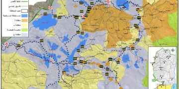
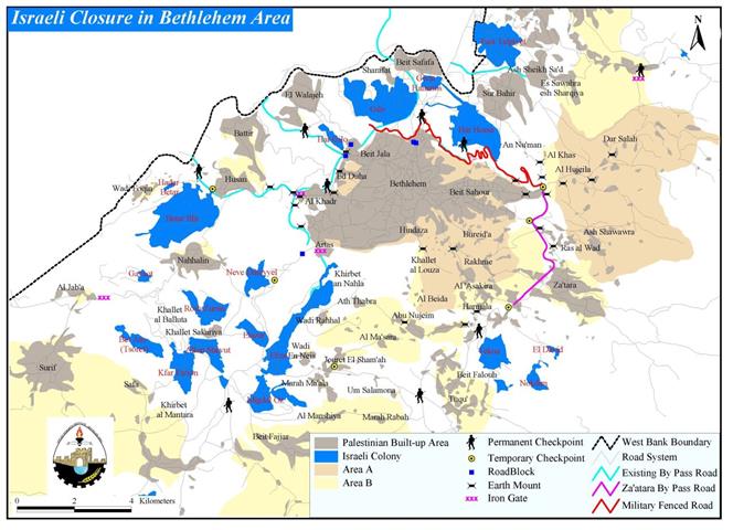
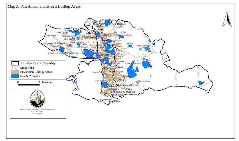
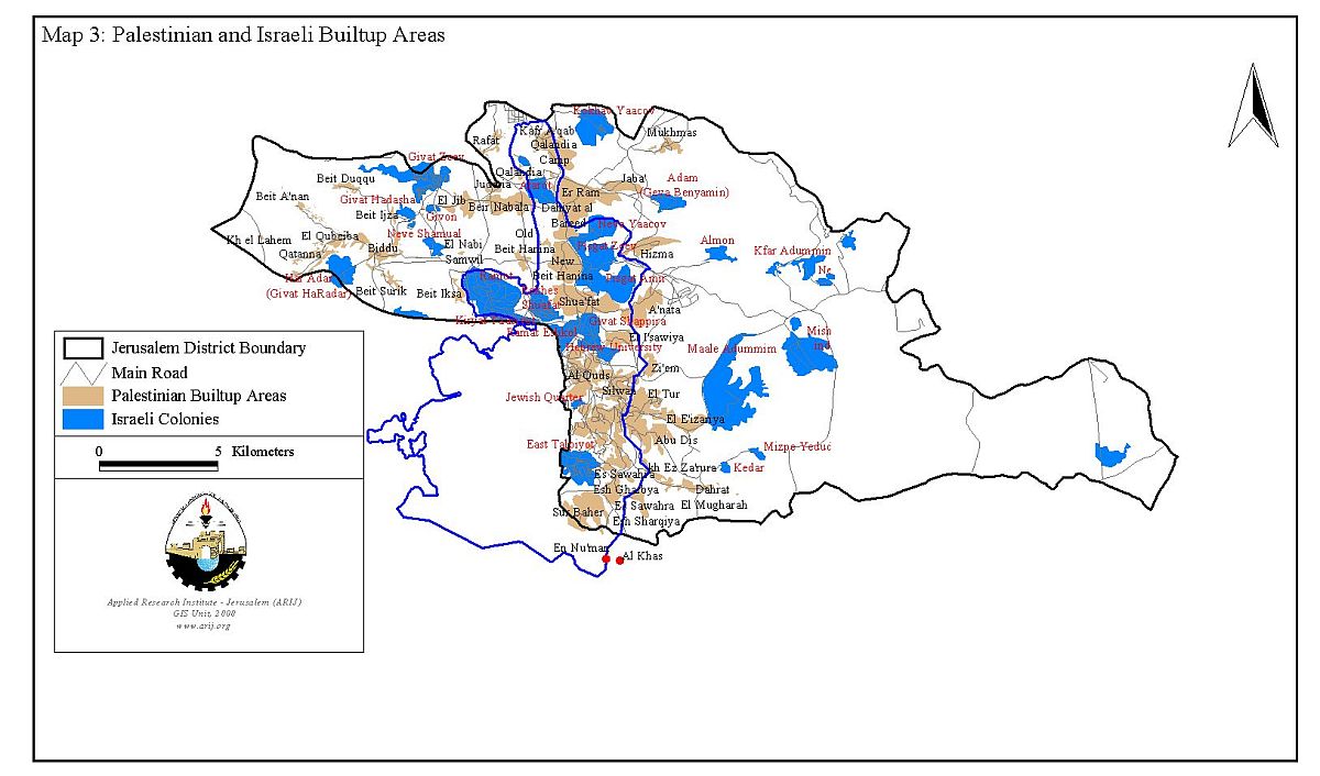
In Jerusalem, Israel expanded the borders of East Jerusalem from 6.5 km2 to 71 km2 to cover areas from Ramallah and Bethlehem districts. Those borders were drawn to include as much vacant land and as little Palestinian built up areas as possible. Today Israel is in complete control of the city, yet most of the property and real estate still legally belong to the indigenous Palestinians who have been living continuously in Jerusalem for centuries. Israel's intensive development program after 1967 has involved the construction of housing and associated infrastructure in the unilaterally annexed and expanded territory of occupied East Jerusalem, and most recently surrounding the city by the Segregation Wall or the Israeli so-called Jerusalem Envelope. See map of Jerusalem
The Wall around Jerusalem
The Segregation Wall that surrounds Jerusalem, the Israeli so-called Jerusalem Envelope is under construction along the northern and southern borders of Jerusalem. To the south of Ramallah, the Segregation Wall has a length of 8 kilometers.By the 15th of August 2002 a military order was issued to construct a 'Security Barrier', that is the Segregation Wall, to the north of Jerusalem municipality border. This order was issued according to the emergency law of 1949 for land seizure, and since then- August 2002- the land is under the control of the Israeli army.
The Segregation Wall that surrounds Jerusalem, the Israeli so-called is under construction along the northern and southern borders of Jerusalem. To the south of Ramallah, the Segregation Wall has a length of 8 kilometers.By the 15 of August 2002 a military order was issued to construct a 'Security Barrier', that is the Segregation Wall, to the north of Jerusalem municipality border. This order was issued according to the emergency law of 1949 for land seizure, and since then- August 2002- the land is under the control of the Israeli army.
This order is a violation to the Israeli laws as the area mentioned in the military order is annexed to the Israeli municipality of Jerusalem and obeys the civil law not the military law. However, the Israeli Authorities explains that the army is taking control over the lands in that area due to urgent security reasons. The work to erect the corresponding part of the Segregation Wall around Jerusalem started on the 22nd of August 2002 at the village of Rafat.
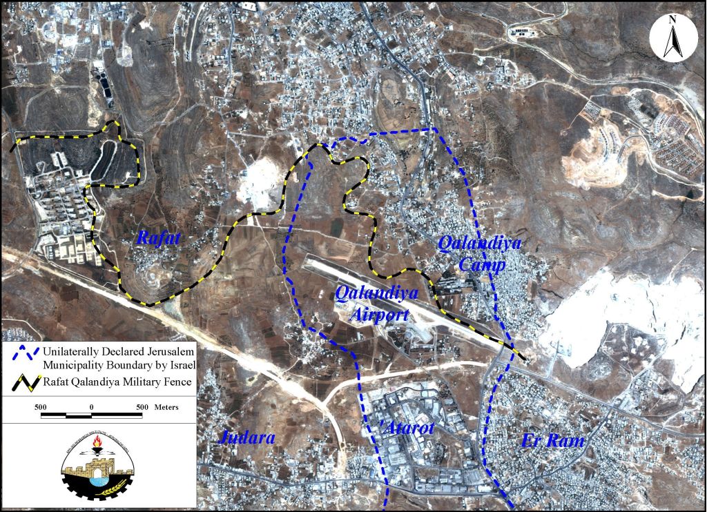
The part of the fenced Segregation Wall in Ramallah is now expanding over the lands of villages located to the North of the district. The villages are: Al-Ram ( Khalet el Sheikh), Qalandia, Kufr Aqeb, El Bireh ( Rafat al Massioun) and Rafat. The length of this new barrier is 8 Km, with a width ranging between 40 to 100 meters. The area of the isolated lands is 500 dunums, and another 300 dunums will be a military restricted area as a security zone along the path of this barrier. See Map of Rafat Fence
Effects of the Wall:
1- The spatial analysis reveals the following facts when the Segregation Wall plan is fully implemented at the northern part of Ramallah district:
2- Around 15,000 Palestinians holders of Israeli IDs from Qalandia town, Qalandia refugee camp and Kufur Aqeb will be enclosed between the new barrier and Jerusalem municipality border. The residents will be paying the taxes as the other Israelis but will not be receiving the same facilities and services as they will be staying in a special security zone.
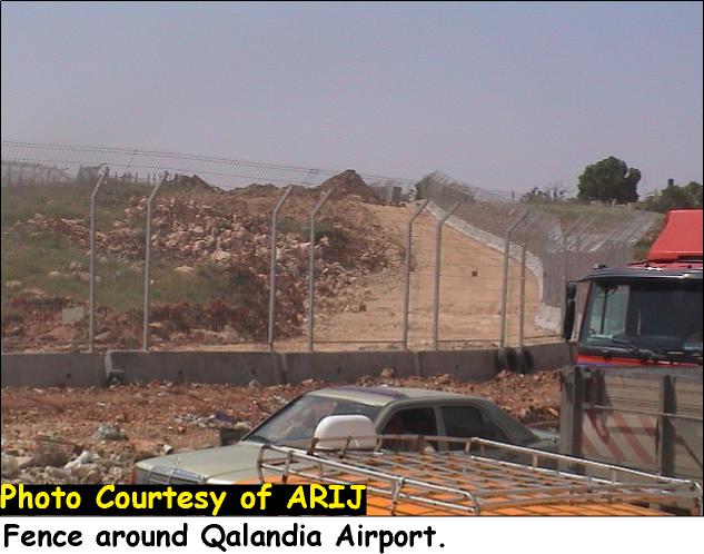
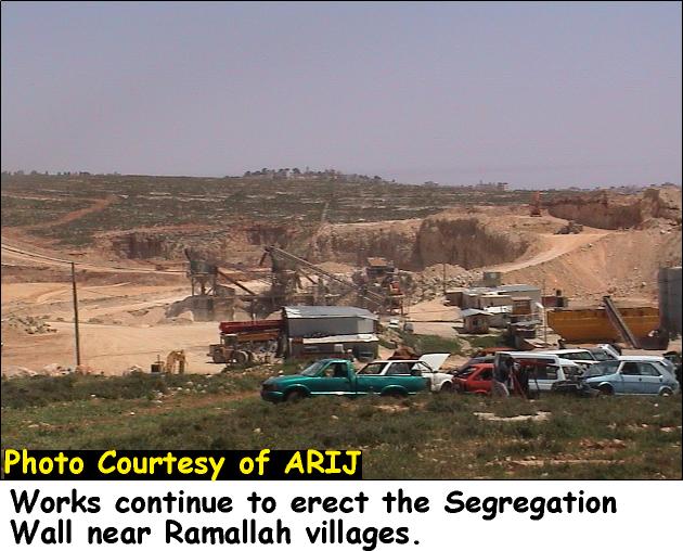
3- Qalandia airport will be annexed and totally controlled by the Israeli Authorities. This act is considered as another violation to the Oslo II agreement that mentions the transfer of this airport to the Palestinian Authority by the final status solution. See Photo 1
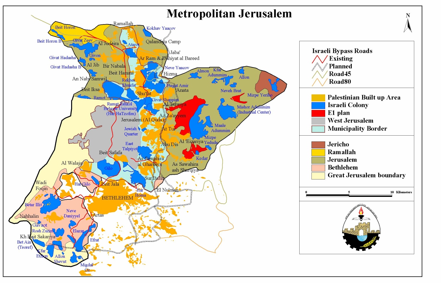
4- The erection of this fenced Wall to the north and to the east of Qalandia's cross road means that there will be a new border adjustment to the municipality of Jerusalem and consequently a new step toward the enlargement of Jerusalem municipality boundaries. See map of metropolitan Jerusalem..
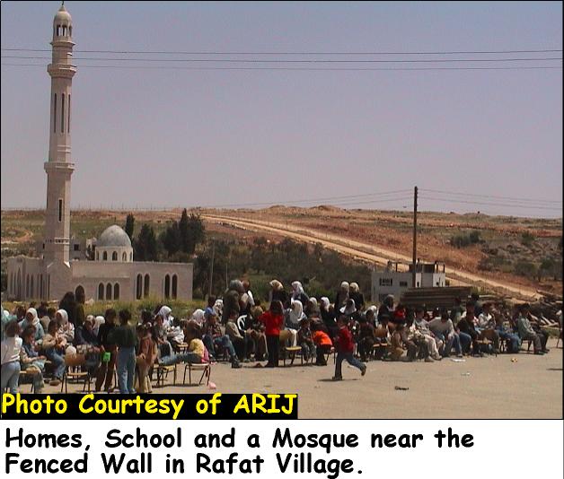
5- Because of the Wall, lands that belong to the villages located to the north of Ramallah are confiscated. Some of these lands are Agricultural and the rest are useful for urban expansion. This act has therefore limited any future urban expansion for those villages. See Photo 2
6- The separation of East Jerusalem from its Palestinian media of the West Bank is paralyzing its commercial, industrial and tourism activities.
7- This barrier will limit the right of free religious worship in the city of Jerusalem for Muslims and Christians living in the West Bank.
8- The Segregation Wall expands to the west causing the separation between the residents of the village of Rafat and their lands that are located to the south and to the west of the village, in spite of the fact that Rafat lands are located within the West Bank Boundaries.
9- In addition, the Wall encloses the lands and the village councils of Qalandia, Judeira, Beir Nabala and Al Ram villages which belong to the West Bank, but will be found in a security zone. The implications of the security zone will be horrible to those people who are holders of Palestinian IDs, as they will be deprived of their free movement, and will not have the right to build new houses, therefore will be endangered indirect migration.
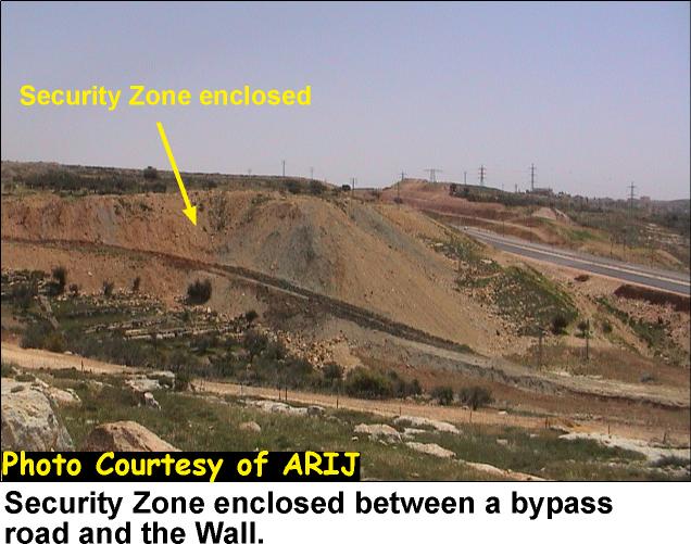
10- Near the village of Rafat a by-pass road along with the fenced Segregation Wall is creating a security zone of 600 dunums. The land in this zone is planted mainly with olive trees. Bitunia military camp that is close to the village seizes a land of 800 dunums.
11- The total area of Rafat village is 4580 dunums, after the land confiscation for different Israeli security and military purposes the village is left with about 330 dunums of land. Meaning that Rafat village will loose 75% of its original lands. See Photo 3 & & Photo 4
Conclusion
The Israeli Authorities are applying all methods aiming at depopulating the Palestinian land from its original inhabitants, increasing the tension between the Palestinians and the Israelis through actions that oppose the Road Map plan. The fact that more lands are isolated from the West Bank means less open space to the Palestinians and strangulating the Palestinian cities, towns and villages. The Separation between East Jerusalem and the West Bank is a new De facto implementation on the ground, preempting the two states vision solution and therefore making no advancement towards peace.
Prepared by:
The Applied Research Institute – Jerusalem

&
Land Research Center-Jerusalem