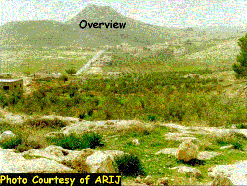
Hebron District is located in the southernmost portion of the West Bank, 36 km south of Jerusalem City with a total population of 405664 and 45 colonial built up areas, scattered all over Hebron. The presence of Israeli settlers in Hebron is a source of constant suffering for the Palestinians. The Palestinians that reside in Hebron live in extraordinary conditions that disrupt their daily lives in ways that make peaceful coexistence practically unattainable.
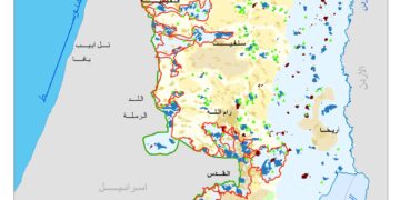
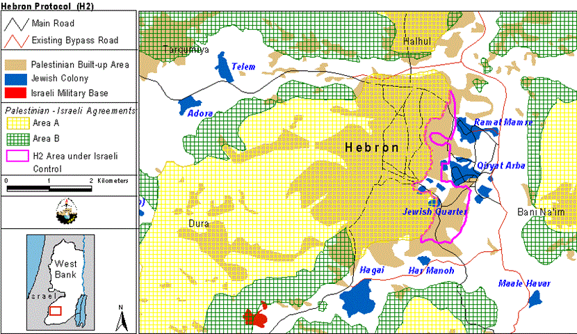
Article XXXI, point seven of Oslo II Interim Agreement states that: 'Neither side shall initiate or take any step that will change the status of the West Bank and the Gaza Strip pending the outcome of the permanent status negotiations'. According to Oslo II agreement signed on September 28, 1995, the West Bank (except for Jerusalem) was divided into three areas of type A, B and C. Areas A to include Jericho and other Palestinian districts such as Jenin, Nablus, Tulkarem, Qalqilyia, Ramallah, Bethlehem and Hebron. B areas would include those areas under the Palestinian Authority control in which it would have the sovereignty over towns and not total, whereas the Israeli Government would have the power to manage the rest of the places in planned area B. C areas would remain under full Israeli control. The first withdrawal of the Israeli army from the Palestinian territories took place in December 1995, but it was not complete because of the problems that came up in Hebron due to the presence of Israeli settlers within the city boundaries causing a delay of redeployment and division of the city into two parts H1 and H2 when the second withdrawal of the Israeli army took place in January 19, 1997, in which the Palestinian Authority exercises civil authority over Palestinians in both areas, while Israel retains control over internal security and public order in H2. See Map 1
Changes are being unilaterally enforced by Israel upon the people of Hebron district neglecting the process of previously negotiations and agreements and highlighting the will and ability of Israel to make changes that disregard Palestinians and targeted to make their lives harder. Clashes erupted in September 2000 showed an ominous Israeli vision of the future shape of the West Bank and Hebron district is only one case in point illustrating the threat posed to the viability of its existence.
Lately, in November 15, 2002, the Israeli Government declared the establishment of a 300 meters promenade with 3 meters high concrete walls erected on each side on the existing road leading to Ibrahimi Mosque in addition to a new road with a length of 400 meters to link this promenade with Kiryat Arba settlement. Thus linking the settlement with the Jewish neighborhood located at Hebron city center, which according to the Israeli Government will reinforce the safety of Jewish settlers and at the same time eliminating the Palestinian presence in the old city of Hebron. The Government also declared the non-validity of 1997 agreement concerning the redeployment in Hebron district between the late Israeli Prime Minister Netanyahu and the Palestinian President Yasser Arafat. For more details, click here.
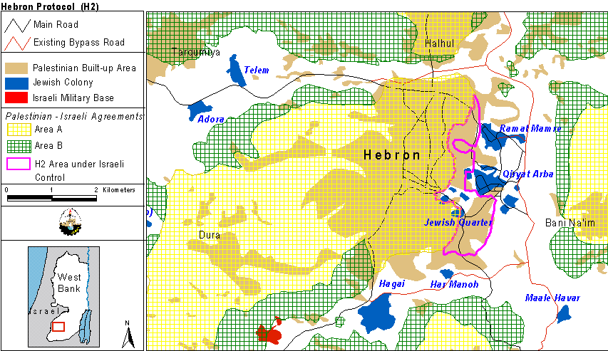
Kiryat Arba settlement was established in 1968 and lies at the northeastern part of Hebron district. It accumulates a population of almost 6323 Jewish settlers and occupies an area of 604.375 dunums. Last week, the Israeli Bulldozers started razing more agricultural lands belonging to Al Natshe family living close to it and constantly suffer from settlers harassments. The Israeli plan suggests the expansion of the settlement borders as well as creating a geographical contiguity with Ramat Mamre (Kharsine) settlement to the north of Keryat Arba to include more lands at favor of its convenience. In addition, the plan also threatens 230 families living in the north of Ramat Mamre (Kharsine) settlement if the Israeli plan completely implemented. See Map 2
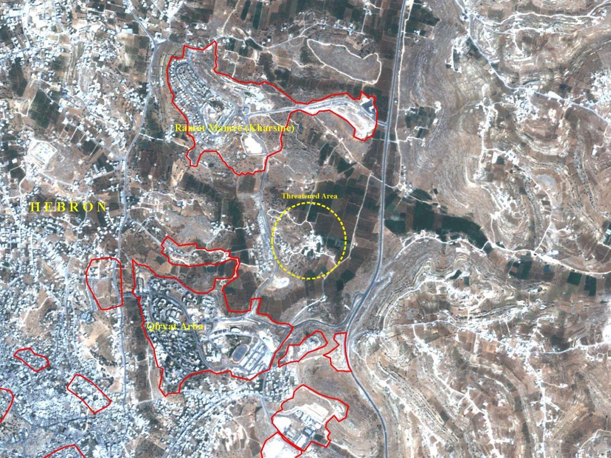
In the area located between Qiryat Arba settlement and Ibrahimi Mosque, the Israeli forces razed more than 70 Dunums of Land cultivated with Fruitful trees which belong to Dana and Al Razem families, also warned three members of Dana family to demolish their houses within 96 hours from date of warning. The houses belong to
|
Name |
Area of House |
Number of people living in the house |
|
Shaker Shukri Da'na |
200 |
13 |
|
Abdel Halim Shukri Da'na |
190 |
15 |
|
Nu'manShukri Da'na |
200 |
12 |
The original Israeli plan to expand Qiryat Arba settlement is carried out in stages as Ramat Mamre (Kharsine) settlement is included within the plan prepared by the Israeli Government in the Eighties, and this unprecedented performing of land razing is just a beginning.
These activities by the Israeli government of land grab and settlement expansion are in total violation of international law as well as the standing agreements between Israel and the PNA. The fact that Israel continues in its policy of depopulating Palestinian areas lying in Area C (especially those close to Jewish settlements shows that the Israeli Government intends to transform the West Bank to suite its ambitions while at the same time allowing for the continuous growth of Israeli settlements.
Prepared by:
The Applied Research Institute – Jerusalem