Historical and Geopolitical Background:
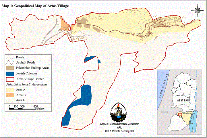
The village of Artas is located to the southwest of Bethlehem district in the West Bank with a population of 2679 people. The village is having a high historical value for the fact that it contains Solomon's pools and is considered as a recreational center in the city of Bethlehem. The geopolitical map shows that the percentage of area ''A'' is 29.5%, Area ''B'' is 11.5% (civil Palestinian control and Israeli security control) and Area ''C'' is 59 % (full Israeli control) according to the Oslo II interim agreement). Map 1
The land area that belongs to Artas village and owned by the people of Artas was originally 13,850 dunums during the Ottoman period in Palestine. In the year 1933 during the British mandate, the village total area decreased to 4,304 dunums distributed as the following:
-
Block (1): composed of only one parcel that is called ' Um Attale'.
-
Block (2): composed of the following parcels: Um Rukba- Daher Baqo- Hariket Hasanat- Wadi Ghneim – Sha'b Sultan.
-
Block (3): composed of the following parcels: Naqora- Wadi Artas- Harikat Milia- Abu Zeid Mountain – Sha'b Suliman.
-
Block (4): Wadi Artas – Wadi El Khokh- Harikat Sanad- A'ttan.
-
Block (5): The village Built-up area.
-
Block (6): Magharet Khaled mountain ( Khaled's cave mountain) with an area of 462 dunums.
-
Block (7): called as Waqef Suliman with an area of 362 dunums and it belongs to the Islamic Waqef.
-
Block (8): composed of Khirbet A'lia and khilet Al karwish.
-
Block (9): composed of Sha'b abu Zeid and Al Nahhla, which are belonging to the people of Artas.
The people of Artas village own other lands outside the village geographical boundaries such as Beit Sukaria, Wadi Rahhal and Thabra located to the southeast of the village. See map 2
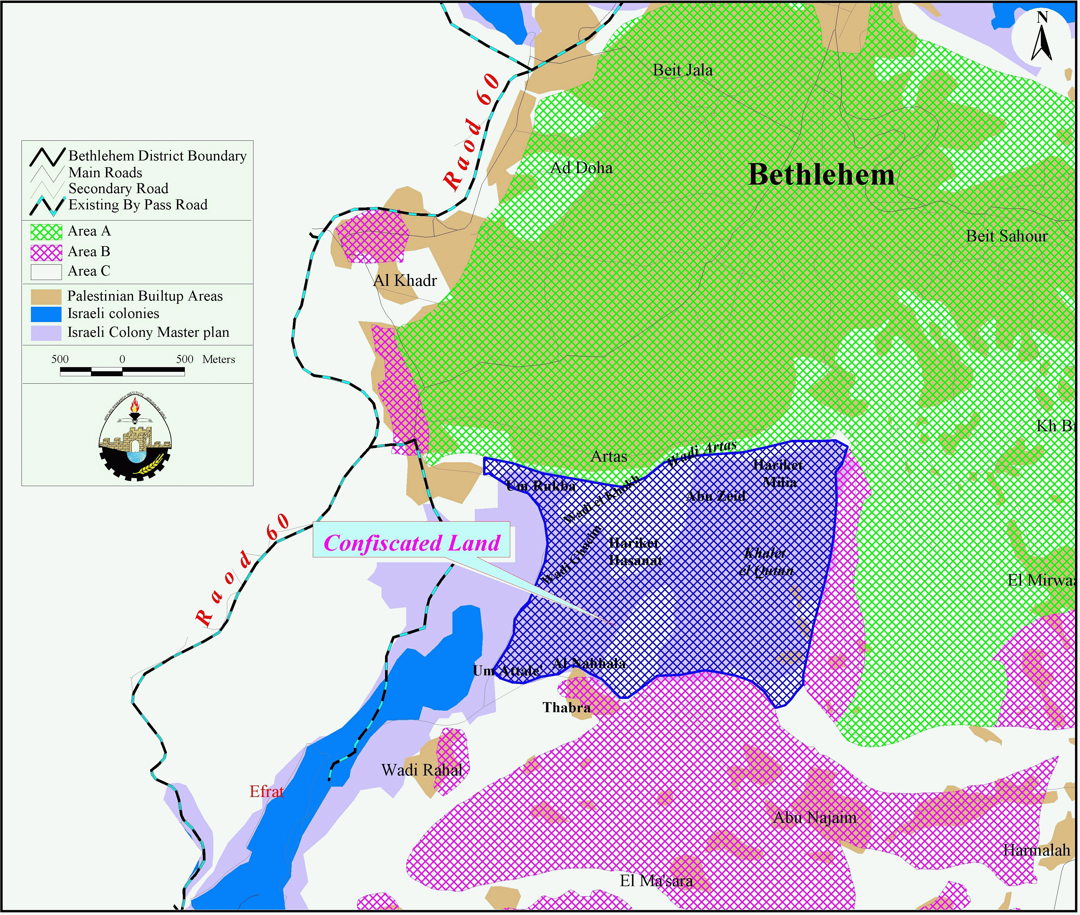
The lands that belong to Artas people in Beit Sukaria spatially expand over 2,000 dunums. The people of Artas own the land since 200 years. Today, those lands are colonized under the name of Kfar Etzion. The families that are the original owners of those lands are: See Table
|
Family Name |
Area of Land in Dunums |
|
Odeh (Sa'd) |
750 |
|
Asa'd |
710 |
|
Shahin |
200 |
|
Abu Swey |
200 |
|
Sanad |
30 |
|
Othman |
25 |
|
Isma'il |
50 |
|
Total |
1965 |
The land located to the south of the village known as Wadi Rahhal, Thabra and khalet al koten covers 3000 dunums, whereby 200 dunums of those lands belong to Khalawi family and the rest for the families of Odeh, Abu Swey and Sanad (Most of these lands where protected from confiscation). See map 3
Series of land confiscation in Artas village:
1- After the 6-days war in the year 1967, the area of Beit Sukaria was the first to be colonized in the West Bank, the name was changed to Kfar Etzion constituting a part of the Etzion Block. This colonial block is very important to the Israeli Authorities as they consider it as a part of the planned Metropolitan Jerusalem project. Historically, the block-as mentioned above- was built on Artas village land.
2- On the 9th of January 1991, a military order n0 (8/91) was issued by the Israeli Government declaring part of Artas village land as a State Land. The land confiscated is 120 dunums and belong to Odeh, Othman and Abu Swey families.
3- On the 12th of March 1991, the Israeli Occupation Authorities issued another tender n0 ( 16/91) declaring another 732 dunums of land from Blocks 3&9 in the village as state Land. See military order 1.
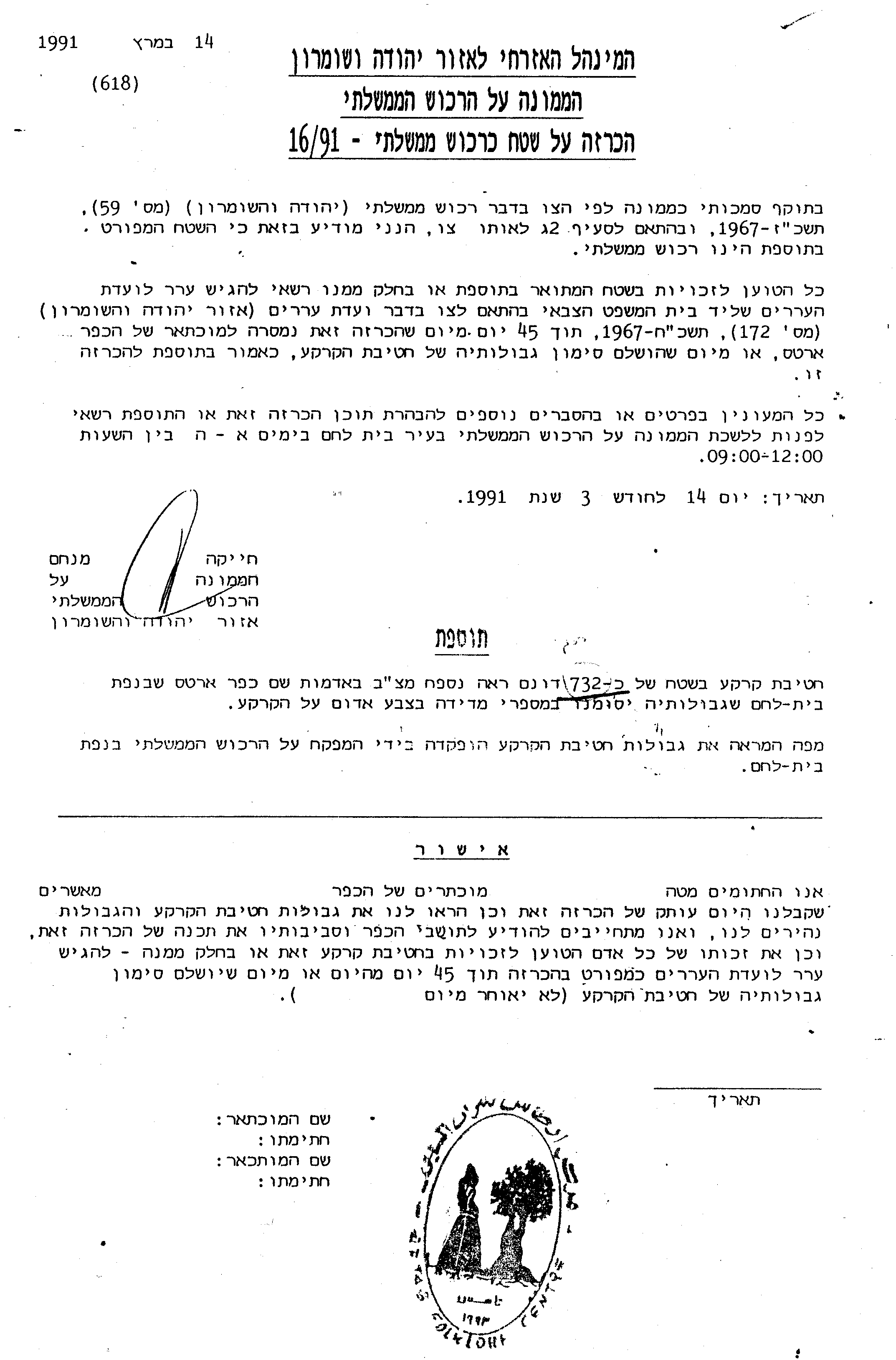
Military order Number 16/91: declaring 732 dunums of land from Block 3&9 in Artas village as state land.
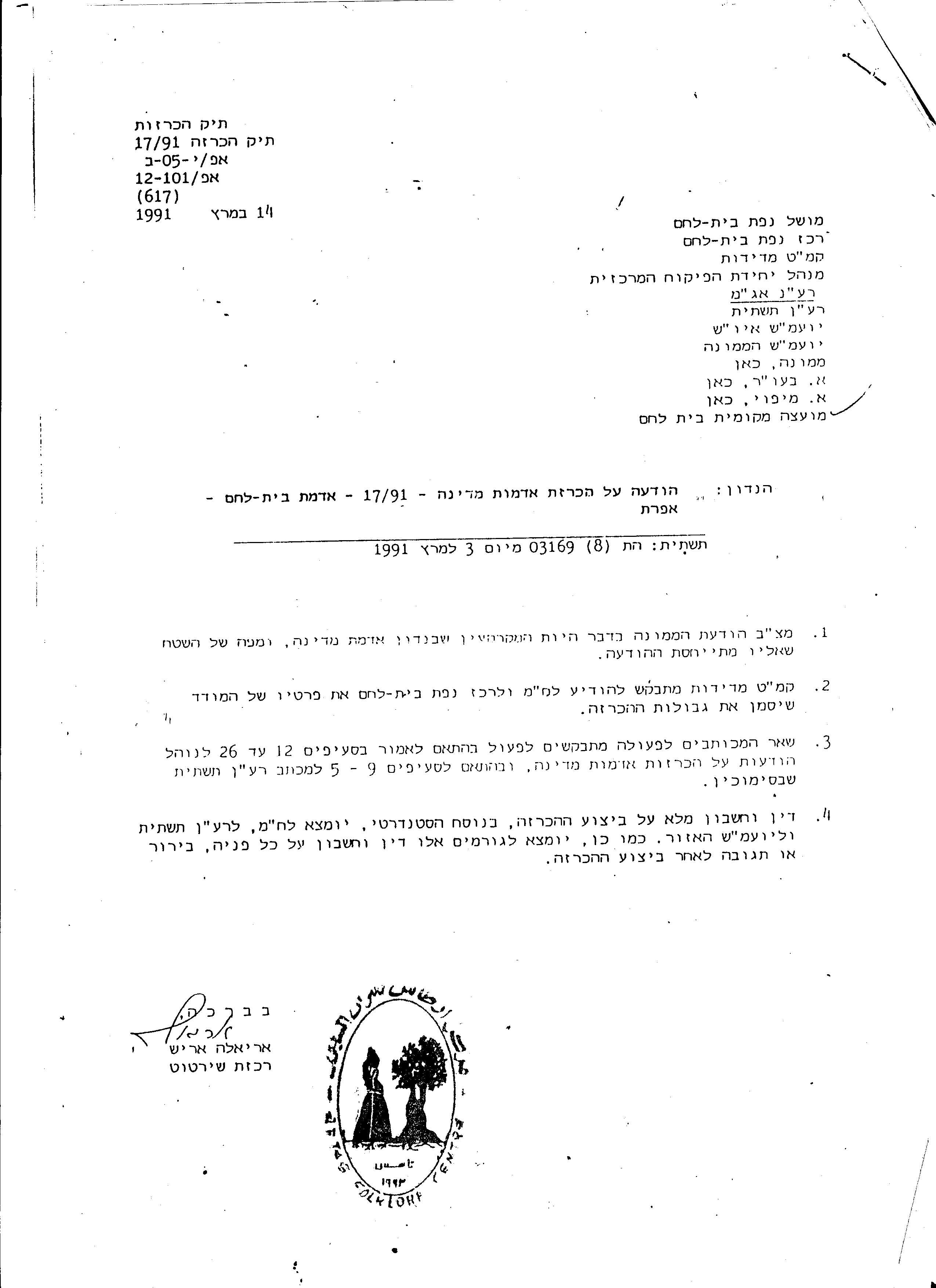
4- On the 14th of March 1991, the military order n0 ( 17/91) was issued declaring an area of 1,432 dunums as a State Land. Those lands were used later on to construct military sites and to prepare basic infrastructure for future settlements. See military order 2
5- In the year 1991, 10 dunums belonging to Abdallah abu Swey from Artas village, were confiscated to enlarge road 60.
Announcement in Al-Quds daily newspaper -16/03/1992
6- On the 16th of March 1992, an announcement from the Israeli military administration in the West Bank was published in Al-Quds daily newspaper declaring the following: '' the Israeli administration had established a detailed master plan map for the settlements of Efrat, Gava'ot, Hazeit, Hatamar and Hadegen over Artas (Block 1,2 &7) and Al-Khader villages (block 8) lands''. Al-Quds daily newspaper 16-03-1992. See Announcement
7- On the 14th of March 1994, a tender was published in Al-Quds daily newspaper, declaring the confiscation of 150 dunums of land from the village, for the purpose of constructing a new by-pass road connecting Efrat Settlement with West Jerusalem.
8- In the year 2002, around 100 dunums were confiscated from Oum Attale' area in Artas in order to construct Israeli military sites.
9- In February 2003, the Israeli bulldozers started to uproot trees, to construct a new road and to place new caravans as outposts in Khilet Al Nahhel, Khilet Al Koten and the Monastery called ''Orthos Conclosus'' lands. Those lands are referring to the blocks declared as state land in the points 3&4 of this report. Confrontations were taking place between the residents of the village and the IOF to stop this violation. Today, the IOF is prohibiting the people from reaching the area and try to arrest the owners if they come to defend their land.
Summary:
The original area of Artas village is supposed to be 4,304 dunums according to the British mandate register records. The people of Artas own lands, which are located beyond the village geographical border, mainly in Beit sukarya and Wadi Rahhal areas. Most of Beit Sukarya lands were confiscated to construct Kfar Etzion settlement as a part of the Etzion colonial block and is having an area of around 2000 dunums. The Israeli religious settlers living in the Etzion Block keep creeping towards the land of Artas, where today the village owns 1,406 dunums of land. The Israeli government policy behind that is to deprive the residents of the village from any future sustainable development and expansion. A genuine intervention by the international community should be imposed to stop Israel's land ware.
Prepared by:
The Applied Research Institute – Jerusalem


