Bethlehem district is living under apartheid and strangulation as many other Palestinian cities in the West Bank because of the surrounding settlements, bypass roads and checkpoints. The district has been cut into slices through many checkpoints and roadblocks, as a part of the Israeli government policies to separate and strangulate Palestinian built-up areas including Bethlehem.
Since the beginning of Al-Aqsa Intifada in September 2000, the Israeli occupation forces (IOF) started to block the roads leading to Palestinian cities and villages. The most suffering communities in the West Bank are those who are located near illegal Israeli settlements. The result is that Palestinians especially those living in such areas are not able to reach their urban centers by any mean of transportation. For example, a huge Israeli military camp and roadblocks are preventing people who are living at the western side of Beit Jala town from reaching their town center or Bethlehem City with their own private cars. The location of this military camp is known as the DCO (District Cooperation Office), which was used for Israeli-Palestinian security meetings during the peace accords.
The road crossing at the DCO vicinity is leading to:
1. Al-Khader village southwest of Bethlehem city and therefore lead to Hebron city.
2. Al-Walaja road, which lead to Jerusalem city, where another Israeli checkpoint is located at 1 km from the DCO road crossing and prevents the Palestinians from reaching Jerusalem.
3. Road 60 (Tunnels road) that has a permanent checkpoint preventing Palestinians from passing to Jerusalem.
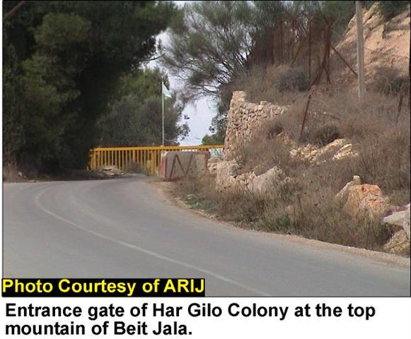
4. Har Gilo settlement that was founded in the year 1976 at the hilltop of Al-Ras mountain of Beit Jala, with a population of 400 inhabitants and an area of 248 dunums (ARIJ, GIS unit, 2002), See Photo 1

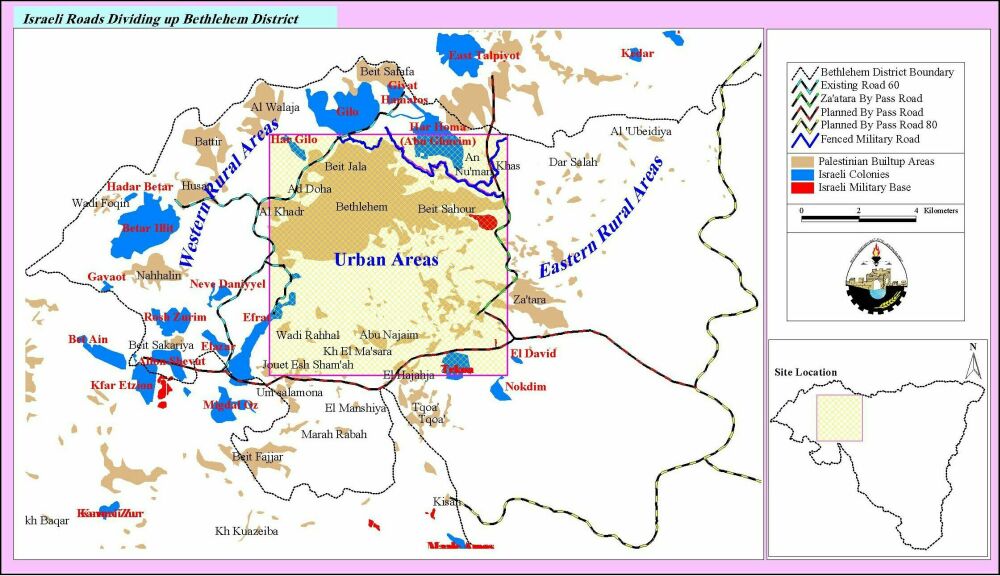
The IOF blocked Al-Nuzha road in front of the DCO and all other secondary roads leading to that area considering it as an important security zone, for the fact that it is leading to Har Gilo settlement and to Jerusalem. Also, an Israeli military presence is always found, represented in military patrols and guard towers. This action is isolating approximately 1,500 people living in Al-Walajeh village and the western part of Beit Jala. It is worth mentioning here that this area is considered as an area C i.e. under temporary Israeli security and civil control and was supposed to be transferred to the Palestinian authority 18 months within the inauguration of the Palestinian council; nevertheless it should always be accessible to Palestinians according to Oslo Agreements, See Map 1.

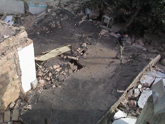
Al-Khader village is also having 3 checkpoints preventing the people mainly from reaching Hebron city, the rest of western rural areas and localities in Bethlehem district. The human suffering faced at these checkpoints each day is increasing, especially during winter; where the people are obliged to use alternative unpaved roads through the valleys and agricultural lands, See Photo 2 & Photo 3


Recently, the Israeli occupation forces have introduced an iron gate of 7 meters in length and 2 meters in height, as a new roadblock between Al-Khader and Artas villages at an area called Oum Rukbeh, See Map. The Gate is observed by the IOF from a nearby installed guard tower that is put at the heart of a Palestinian residential area. This new checkpoint is preventing the people from reaching the village of Wadi Rahhal, See Map 2, Photo 4 & Photo 5


Furthermore, Israeli settlers from Efrat settlement seized a land by force from Al-Khader village belonging of Ahmad Salim Issa and bulldozed 2 dunums of his land.
The farmers in Al-Khader, Wadi Rahhal and other villages are having a serious problem reaching their agricultural lands. The isolation policy that the Israeli government is applying in the rural areas of Bethlehem district aims at complete separation of eastern rural areas from western ones. The district became divided into 3 parts: Eastern rural areas, Western rural areas and urban center, See Map 2. The separation is also achieved through the existing and planned bypass roads surrounding the district.
Below are the main Israeli bypass roads that divide Bethlehem district:
-
Road 60, located west of Bethlehem district, separates the western rural areas from the main urban areas. Thus, a total of 15,000 people cannot commute towards the urban centers because of the presence of checkpoints and roadblocks erected on the road.
-
Za'tara planned bypass road is located east of Bethlehem district and is currently under construction. This road will separate the eastern rural areas from the urban center strangulating a total of 17,000 people.
-
Planned bypass, Road 80, will be located at the southern boundaries of the district to connect the settlements in Etzion block with the settlements constructed at the eastern parts of the district such as the settlement of Nekodim. As a result, Bethlehem district will be totally separated from Hebron district.
-
The fenced military road constructed north of the district will be connected to Road 60 from the west and with Abu Ghunaim or Har homa settlement from the east. The road creates an Israeli security zone made up of Jewish settlements and military bases that is both inaccessible and forbidden for Palestinians. This vast area annexed makes Jerusalem even more distant and separated from Palestinians in Bethlehem district. See Map 3.

Today, Bethlehem district, as well as the rest of the West Bank, is living a real strangulation, its entrances are all blocked and controlled by the IOF. The socio-economic effect of all this segregation is severe; farmers are not able to reach freely their lands and transporting their products to the urban areas. So, there is a policy that the Israeli government is applying which is isolating the Palestinian from his land.
All these acts of segregation and isolation are against the agreements signed between Palestinians and Israelis as it can be analyzed from the following paragraph from Oslo Agreement: 'After the inauguration of the Palestinian Council, the unity and integrity of the Palestinian people in the West Bank and the Gaza Strip shall be maintained and respected. All Palestinian people residing in the West Bank and the Gaza Strip will be accountable to the Palestinian Council only, unless otherwise provided in this Agreement.'' (Oslo II Agreement,Annex1, Article 1, section 4).
See related links see:
-
More Land Confiscated to build By-Pass Road in Za'tara (June 2002)
-
An Israeli Fenced Military Road North Of Bethlehem District (May 2002)
Prepared by:
The Applied Research Institute – Jerusalem