Historical Background:
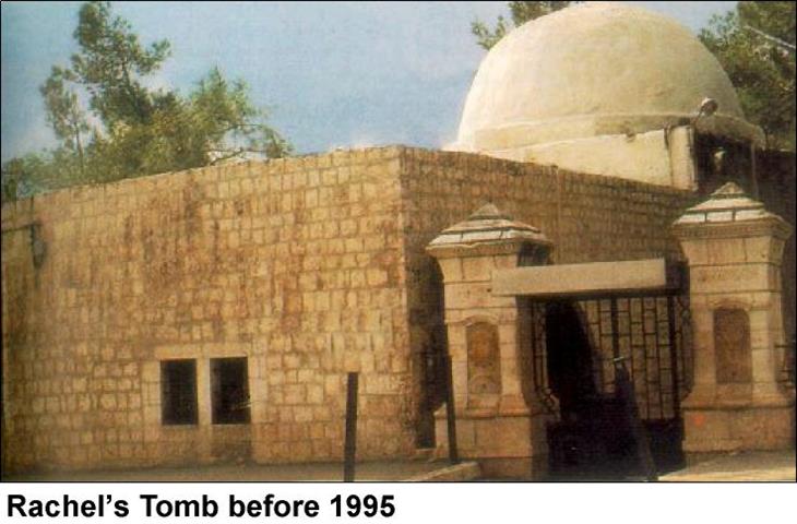
The Tomb of Rachel, which is located at the northern part of Bethlehem, is considered to be a holy pilgrimage place for Christians, Moslems and as well as Jews. Rachel, the wife of Jacob died in childbirth on the way to Hebron, and she was buried on the road to Bethlehem. The tomb was neglected during the years until the crusaders rebuilt it. It was composed of a square building of 7m square, formed by 4 columns bound by pointed arches of 3.5m wide and 6.5m high where the whole is crowned by a cupola (described by Amico in the year 1596). The simple building which houses '' the tomb today'' was erected by the Turks in 1620 during the Ottoman period, and so Moslems considered the place so sacred for its relation with Abraham and thus kept it's keys. In 1841, Sir Moses Montifiori asked the Turkish governor for the keys of Qubbet Rahil or Bilal bin Rabah Mosque, as it is spelled in Arabic, and were given to the indigenous Jews also a square vestibule with a Mihrab was added for the Moslems, a historical Islamic cemetery is also found to the west of this shrine. Rachel's Tomb is considered to be one of the historical monument sites in the city of Bethlehem and a part of its heritage. In addition, the people of Bethlehem and tourists of all around the world of different religions always visited the tomb. Since the past two years, the Israeli occupying forces prevented Christians and Moslems to visit the place denying the Palestinian right for worship, Moslems right to burry their dead people in their nearby cemetery freely and limiting this shrine on Jewish groups as a primary action to annex the place to the city of Jerusalem.
Rachel's Tomb and the Oslo Agreement:
According to the Oslo II Agreement signed in 1995, the location of the Tomb falls in area C of the Bethlehem district i.e. under temporary Israeli security and civil control keeping the right for Palestinians to use the main road, where Area C was supposed to be transferred to the Palestinian Authority (P.A.) within 18 months of the inauguration of the Palestinian jurisdiction council.
a. Arrangements regarding Rachel's Tomb, which will be considered a special case during the Interim Period:
1. While the Tomb, as well as the main road leading from Jerusalem to the Tomb, as indicated, will be under the security responsibility of Israel, the free movement of Palestinians on the main road will continue.
2. For the purpose of protecting the Tomb, three Israeli guard posts may be located in the Tomb, the roof of the Waqf building, and the parking lot.
b. The present situation and existing practices in the Tomb shall be Preserved ''. (Oslo II Agreement, Annex 1, Article V, section 7).
A confirmed story was leaked to the media at that time that the tomb was supposed to be in area A i.e. under full Palestinian security and civil control, but pressure was exerted by religious parties in Israel at the time of negotiations (1994-1995) in order to keep Rachel's tomb under Israeli control. In 1996, Israel's Ministry of Religion renovated the site adding a new building to the eastern side of the tomb, which is not mentioned in the Oslo agreement, See Photo 1 & Photo 2.


The new Rachel's Tomb consists of the previous structure housed within the expanded and reinforced edifice in addition to 2 military guard towers as seen in As a result, the religious site became an Israeli military camp that is used as a firing position against Palestinian demonstrators during Al-Aqsa Intifada (Uprising).
Since the erection of the Al-Aqsa Intifada in September 2001 and in order to prevent any Palestinian movement beside the entrance of the tomb, Israeli Occupying forces have closed the main road between Bethlehem and Jerusalem and have occupied several Palestinian residential buildings around the tomb and transformed them into military posts as seen in Photo 3.

The new Israeli security cabinet decision:
On the 11th of September 2002, the Israeli security cabinet approved to keep Rachel's Tomb under Israeli control by including the tomb within the separation zone . According to the primary information obtained from the Israeli media, the municipality of Jerusalem and the Israeli occupying forces are going to pave a new road in order to allow free access to the tomb for all Israeli citizens. The Israeli defense minister Benjamin Ben-Eliezer proposed to allow the free access through an overpass bridge or an escalator from a hilltop that ends 500meters north-west of the site; this to avoid any pressure or condemnation due to the fact that many Palestinian homes are going to be demolished, but this plan was directly opposed by Sharon and the majority of ministers.
The path of this new road was never published officially, but according to primarily observed works on the ground, ARIJ field workers try to follow the route of this plan and to estimate the losses represented in land confiscation, home evacuation or home demolition. The road is apparently connecting the tomb with 'road 60' and is going to be of 1 km in length, and approximate width of 20 meters with a 10 meters high wall on both sides of the road will be constructed (according to Israeli media), See satellite image.

The exact path of the road is still not clear, but the borders of the separation wall are already dug and iron razor wires are put in its trenches as we can observe in Photo 4.

About twelve to fifteen Palestinian residential buildings near this new road are under the threat of evacuation or demolition, in addition to the Armenian Church property and an Islamic cemetery, See Photo 5 & Photo 6 & Photo 7


A small industrial complex that consists of about 10 car-repairing garages and a furniture factory are also under the threat of demolition. This road is passing mainly through agricultural lands planted with olive trees, as a result about 400 olive trees are going to be uprooted and lands on both sides of the road would be confiscated or shaved for security reasons. See Table1, Photo 8 & Photo 9


Table -1
|
Primary estimated losses |
Value |
|
Buildings to be evacuated or demolished |
12- 15 (each building contains several flats or apartments) |
|
Lands confiscated for the path of the road |
20 Dunums |
|
Olive trees to be uprooted |
400-500 |
Conclusion:
Rachel's Tomb was always a part of Bethlehem city, and a pilgrimage place for people of the three monotheistic religions. Toady the tomb is becoming a military camp and open only for Jews. As planned by the Israeli government it is going to be annexed to Jerusalem. This de facto policy that the Israeli government is applying, costs the Palestinians a lot of their land, homes and heritage that they have conserved throughout history in addition to the damages in Bethlehem tourist industry and the Palestinian economy in general.
Prepared by:
The Applied Research Institute – Jerusalem


