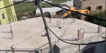
Under the complete darkness at a cold night on Thursday 10/1/2002, the Israeli military forces accompanied by bulldozers stormed a crowded populated quarter at Rafah Refugee camp and demolished 73 houses without evacuating any of its contents of furniture, equipment and others. The owners of these houses got out half sleepy with their pajamas at the sound of fired bullets that preceding the work of bulldozers. They got out of their houses carrying children and running east in an opposite direction to the source of fire unbelieving what is going on as if it is the end of the world.
At the sunrise of the next day, 123 families totaling more than 800 people were becoming homeless and refugees again. Of the last version of refugees, 350 students did not find their books, clothes and school bags. They were not able to go for their final mid-year exams. Maha, a child of eleven years old, asked her mother bitterly: would they at school allow me to do the exams later on, or would they assign me fail grade? her mother was not able to answer but started weeping.
Rafah, the border city:
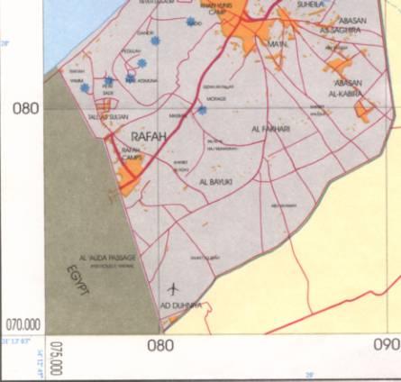
Rafah is located near the Egyptian Palestinian borders and extended horizontally to the west and the south until it intermingled with the borders during the Israeli occupation of Sinai Peninsula. To the south of Rafah, a group of refugee camps were built for Palestinian refugees after 1948 war called Rafah refugee camps area. Of this group is the attacked and victimized Block 5.
After the Israeli withdrawal from Sinai Peninsula and demarcation the international borders, the borderline was directly adjacent to the populated area. When the Palestinian National Authority (PNA) took over the its responsibility at parts of Gaza Strip, Rafah was part of the PNA full control area, but the Israelis demarcated again the borderline and constructed a wide road separating Rafah from the Egyptian borders.
After the eruption of the last Palestinian uprising Alaqsa Intifada and the deterioration of the security situation, the Israeli army intensified the forces presence at the border area. Israeli forces strictly closed and besieged Rafah Governorate that is surrounded by Israeli settlements from the north and the east represented in Yam, Etsmona, Morage and the Israeli army from the south and west.
Israeli violations conducted against Rafah Governorate during the Intifada:
The following are the Israeli violations conducted against Rafah Governorate during Alaqsa Intifada:
- The excavation and bulldozing the agricultural land with all its contents of greenhouses, irrigation networks, wells, pumps and equipment adjacent to the borders and owned by the residents of Rafah. By this action, the Israeli forces created a buffer zone with a width ranging from 200 to 500 m adjacent to the Egyptian borders and north and south of Rafah and its refugee camps. Only the urbanized area is remaining. The estimated devastated land is about 2000 dunums containing about 120 dunums of greenhouses and about 30 irrigation wells. 40,000 trees were uprooted during this process.
- Establishing several military towers on the borders adjacent to the urbanized area of Rafah and refugee camps.
- Shelling and destroying any house that they suspected that they were fired from its surroundings that lead to the inhabitants transfer.
- 368 houses adjacent to the borders were demolished. Most of these houses are from the refugee camps. This number includes the last demolished houses (73) in Block 5.
- Partially demolition of 520 houses that were becoming unsuitable for living in.
- Transferring about 900 families totaling at 6200 people from their houses adjacent to the borders.
- A new status quo was imposed as an introduction to connect the security belt north of Rafah with that in the south. The urbanized area becoming ready to make a security belt zone with a depth of 70-250 m.
- Supposing that the Occupation Authorities will be satisfied with creating a belt zone with a width of 200 m, it means that about 650 houses are waiting to be demolished to finalize this military plan.
- As a result of the occupation policies 37 martyrs killed and 1500 wounded in Rafah Governorate alone since the beginning of this Intifada.
- As a result of excavation and bulldozing, the sewage network with the connected pump were destroyed which lead to the destruction of all the sewage system and the flow of brackish water in the streets and farms. This has a severe negative environmental impact on soil, water, agriculture and public health taking in consideration that the area is intensively populated.
Contradictory attitudes:
- The Israeli Government claimed that the demolished houses are uninhabited and they are used as a cover to smuggle weapons between Egyptian and Palestinian land and the number of these houses is just 21.
- UNRWA and its General Commissioner emphasized the Palestinian number of demolished houses and pointed out that it is inhabited and even crowded. All the inhabited people are UNRWA registered refugees.
- The USA administration justified the demolition policy and considered it as an Israeli self-dense.
- Dr. Eil Gross, an Israeli law professor at Tel Aviv University said that:'' the demolishing orders received by Israeli soldiers from their commanders are illegal and the soldier has the right to reject it''.
- The Israeli security sources indicated the smuggling Palestinian tunnels extend to about 12-17 m.
- Yediot Ahronot Israeli newspaper pointed at an old Israeli plan to rent this border area from Palestinian National Authority and compensate the people. However, the Israeli forces under Sharon government implemented this by force getting advantage of the deteriorated security situation.
Summary:
It is clear from all the above mentioned that the Israeli military and security policy is governing the political mentality. The one who is pushing the situation toward the explosion edge, for the purpose of increasing military control, is not concerned with real peace. This indicates that the Occupation is hiding more surprises for the spectator world and the price is always paid by Palestinian nation.
Prepared by
The Land Research Center
LRC


