• About The Project
  • Palestine in Century
  • Selected Maps
  • Glossary
  • About ARIJ
  • About LRC
  • By Year
    • Case Studies By Year
    • Daily Report By Year
Friday, May 9, 2025
POICA
No Result
View All Result
  • Home
  • Settlements
    • New Israeli Settlements
    • Settlement Expansion
  • Israeli Violations
    • Agriculture
    • Confiscation
    • Demolition
    • Environment
    • Eviction of Palestinians
    • Settlers Attacks
  • Bypass Roads
  • Israeli Plans
  • Segregation
    • Checkpoints
    • Closure
    • Separation Plans
  • Military Orders
  • Reports
    • Daily Report
    • Monthly Report
    • Quarterly Report
No Result
View All Result
POICA
No Result
View All Result

A New Military Road Around Har Homa settlement – Update

December 8, 2001
in Bypass Roads
A New Military Road Around Har Homa settlement – Update


The Israeli plan continues to separate Jerusalem from its surrounding Palestinian communities

Saturday 8th ,2001


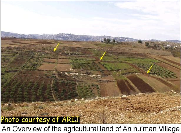
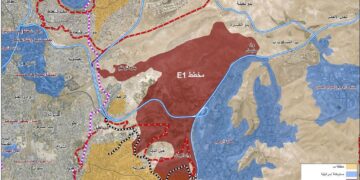
The Israeli bulldozers have not stopped their digging job in spite of  all calls. Photos taken by ARIJ field workers, updated last Saturday 8th of December, clearly   show the large agricultural losses that will be incurred as a result of the masses of land threatened to be confiscated by the Israeli authorities. Another 940m have been acquired towards building the road, leading to the confiscation of 140 dunums (14 hectares) in total. The yellow-black line on the original satellite image indicates the latest development in the construction of the road. See satellite image 

Residents from An Nu'man village have reported that the plan behind constructing this road is to annex the village to the illegal borders of Jerusalem, as well as, maintain a buffer security zone around the southern borders of Har homa settlement. This, in return has adverse consequences on both land and residents of the village. The colonizing plan has separated the An Numan village from its Palestinian surrounding communities, and expropriated hundreds of rich agricultural lands. Latest photos of the new military road around Har homa Settlement.


12th of December.

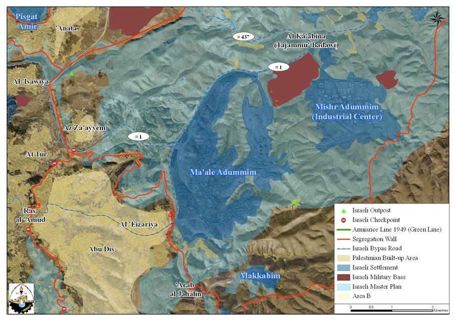
 From what we have seen on the ground and by considering the fact that the Israeli government has already launched its unilateral separation of land between Palestinian territories and Israel, the new military road surrounding An'uman and Al-Khas villages will constitute the southern borderline of the illegal boundaries of Jerusalem municipality drawn after 1967 war. See satellite image .

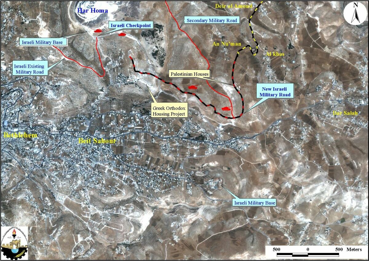
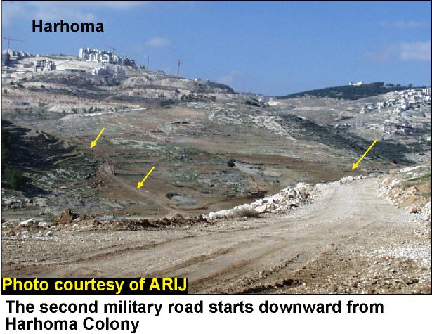
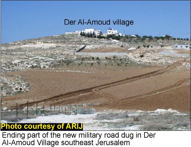
Tracking the ends of the road wasn't an easy task. The road starts from the southern side of Har homa settlement until it reaches the hill of Der Al-Amoud, located in southeast Jerusalem. Both locations are outlawed for Palestinians without a permit, obtained from the Israeli authorities. ARIJ field workers managed to track the road and get some useful and clear pictures of the site.

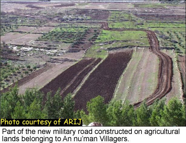
During the venture of being close to such ending points, ARIJ field workers have noticed a second military road with a total length of 2.5 Km. The ARIJ fieldworkers took the risk to enter the road and verify its ending points, hoping that no Israeli tank or bulldozer approaches the area. The fieldworkers found out that this road at a distance of 2.5 km away from its starting point joins the original military road at an intersection. The purpose of constructing this new road is not yet clear. See photo1 & photo 2 


Data calculated from field survey (29/11-!3/12)

Total length of the road

5 Km

Total land threatened

750 dunums (75 hectare)

Total houses threatened

5

Total length of the secondary road

2.5 Km

Source: ARIJ GIS database, 2001.


Five houses are located alongside the road; one of them is still under construction.  These houses are under the threat of demolition or evacuation since they are built 3 to 20 meters away from the road only. See photo 3


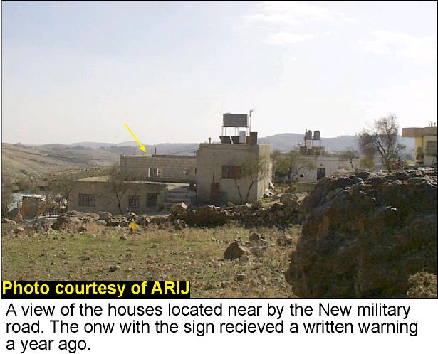
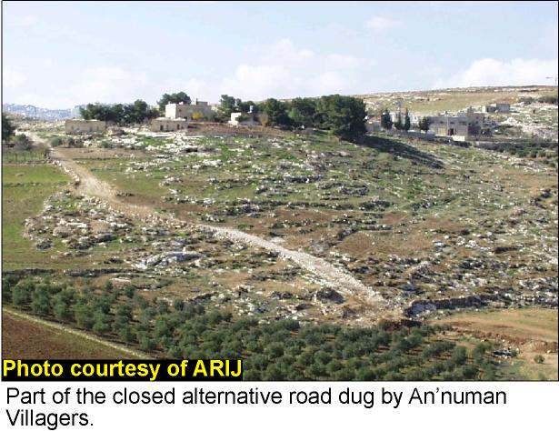
It is worth mentioning here that residents from Al-Khas village confirmed that Israeli field surveys belonging to Jerusalem municipality inspected the land last year and gave one of them, whose house is still under construction, a written warning to stop the construction process. This house is situated 14 meters east of the digging line of the road. Thus, it is implicit that the plan to build this road started almost a year ago. Also, Israeli bulldozers closed the alternative road dug by An'uman villagers in order to reach the surrounding Palestinian communities. See photo 4


Prepared by:
The Applied Research Institute – Jerusalem


Recommended For You

شق طريق استيطاني جديد يهدد سبل العيش في قرية بردلة

by arij
January 13, 2025
0
New Israeli Settlement Road Construction and Its Impact on the Village of Bardala in the Jordan Valley

المكان: تجمع بردلة- محافظة طوباس/الأغوار الزمان: سبتمبر 2024 الجهة المتضررة: أهالي قرية بردلة والقرى المجاورة الجهة المعتدية: ما تسمى بالإدارة المدنية الاسرائيلية الانتهاك: شق طريق استيطاني تفاصيل الانتهاك:...

Read moreDetails

New Israeli Settlement Road Construction and Its Impact on the Village of Bardala in the Jordan Valley

by arij
December 31, 2024
0
New Israeli Settlement Road Construction and Its Impact on the Village of Bardala in the Jordan Valley

  The construction of new settlement infrastructure in the occupied Palestinian territories has profound implications for local communities, threatening livelihoods, increasing isolation, and impairing socio-economic vulnerabilities. This case...

Read moreDetails

الطرق الالتفافية الاسرائيلية وأثرها على البيئة الفلسطينية

by arij
January 16, 2024
0
الطرق الالتفافية الاسرائيلية وأثرها على البيئة الفلسطينية

  الاعتداءات الإسرائيلية على الفلسطينيين لا تقتصر على التنكيل بالافراد، أو وضع القيود على الحركة والتنقل، أو استهداف المنازل والمنشات، أو مصادرة الأراضي، أو نهب الموارد والمصادر الطبيعية،...

Read moreDetails

Israeli Colonists Take Over an Agricultural Road in Ya’bad town / Jenin Governorate

by arij
January 12, 2022
0
Israeli Colonists Take Over an Agricultural Road in Ya’bad town / Jenin Governorate

  Violation: Taking over an agricultural road for the favor of colonization. Location: Ya’bad town / Jenin Governorate. Date: October 17th 2021. Perpetrators: Mevo Dotan Colony. Victims: Farmers...

Read moreDetails

New Colonial road to Be Opened on Sarta Village lands / Salfit Governorate

by arij
July 17, 2021
0
New Colonial road to Be Opened on Sarta Village lands / Salfit Governorate

  Violation: Opening a new Colonial Roads. Location: Sarta village/ Salfit Governorate. Date: June 1st 2021. Perpetrators: The Israeli Illegal Industrial Colony (Barkan). Victims: Farmers from the village....

Read moreDetails
Next Post
New Israeli aggression against Qalqilia

New Israeli aggression against Qalqilia

LATEST NEWS

الأراضي الفلسطينية بين الذرائع الأمنية والأطماع الاستيطانية – “الأمن، الآثار، والطبيعة كحجج لاقتلاع الفلسطينيين من أراضيهم”

by arij
April 15, 2025
0

........................................................

الطرق الالتفافية الاسرائيلية وأثرها على البيئة الفلسطينية

انتهاك للطبيعة والهوية في الأراضي الفلسطينية المحتلة

by arij
March 17, 2025
0

........................................................

Israel Advances Settlement Plan on Ancient Olive Groves on lands of Beit Jala city, Violating International Law and depriving Palestinians their lands

إسرائيل تمضي قدمًا في مخطط استيطاني جديد على أراضي مدينة بيت جالا، في انتهاك للقانون الدولي وحرمان الفلسطينيين من أراضيهم

by arij
April 29, 2025
0

........................................................

Israel Advances Settlement Plan on Ancient Olive Groves on lands of Beit Jala city, Violating International Law and depriving Palestinians their lands

Israel Advances Settlement Plan on Ancient Olive Groves on lands of Beit Jala city, Violating International Law and depriving Palestinians their lands

by arij
April 29, 2025
0

........................................................

flag_yellow_lowEU-PfP-Logo

This website has been produced with the assistance of the European Union. The contents of this publication are the sole responsibility of ARIJ & LRC and can in no way be taken to reflect the views of the European Union.

© 2025 Copyright ARIJ . All Rights reserved. .

No Result
View All Result
  • Home
  • Settlements
    • New Israeli Settlements
    • Settlement Expansion
  • Israeli Violations
    • Agriculture
    • Confiscation
    • Demolition
    • Environment
    • Eviction of Palestinians
    • Settlers Attacks
  • Bypass Roads
  • Israeli Plans
  • Segregation
    • Checkpoints
    • Closure
    • Separation Plans
  • Military Orders
  • Reports
    • Daily Report
    • Monthly Report
    • Quarterly Report

© 2025 Copyright ARIJ . All Rights reserved. .