• About The Project
  • Palestine in Century
  • Selected Maps
  • Glossary
  • About ARIJ
  • About LRC
  • By Year
    • Case Studies By Year
    • Daily Report By Year
Friday, May 9, 2025
POICA
No Result
View All Result
  • Home
  • Settlements
    • New Israeli Settlements
    • Settlement Expansion
  • Israeli Violations
    • Agriculture
    • Confiscation
    • Demolition
    • Environment
    • Eviction of Palestinians
    • Settlers Attacks
  • Bypass Roads
  • Israeli Plans
  • Segregation
    • Checkpoints
    • Closure
    • Separation Plans
  • Military Orders
  • Reports
    • Daily Report
    • Monthly Report
    • Quarterly Report
No Result
View All Result
POICA
No Result
View All Result

Jericho and The valleys … The Israeli occupation imposes separation and military closure on Jericho and the valley

May 21, 2001
in Closure
Jericho and The valleys … The Israeli occupation imposes separation and military closure on Jericho and the valley


The area of Jericho and the northern valleys are considered the main food basket for the Palestinian population in the West Bank. Therefore, the Israeli closure on this area causes far reaching agricultural and economic effects aiming at suffocating the Palestinian economy in general. The total area of Jericho is estimated at 360 square kilometers inhabited by 38 000 people mostly work as farmers and animal breeders. 

Due to movement restrictions, most farmers have been unable to tend their land and yield their crops. The Israeli occupation authorities closed all exits in the face of Palestinians and in, the meanwhile, allowing Israeli settlers to pass through the area by using Jericho bypass east of the city. 

The Jericho area had previously suffered from Israeli military checkpoints because of its remote location and closeness to the Jordanian borders, but since the outbreak of Al- Aqsa Intifada additional military blockades have been added, consequently, causing more difficulties in movement from one Palestinian area to another.


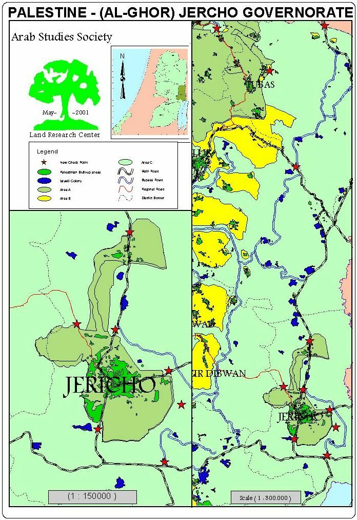
The following are the new army blockades and checkpoints imposed during Al- Aqsa Intifada:

  1. The checkpoint at the southern entrance to Jericho city adjacent to A'qbat Jaber refugee camp has been turned to a permanent military post.
  2. A military barricade cutting the southern road linking between the city and the bypass road No. 90 to stop Palestinians from using this road.
  3. The military blockade to Ein Jedi separating between Jericho area, on one hand, and the Dead Sea and green line on the other hand. This checkpoint was re-enforced recently.
  4. A military barricade to the south east of the Arab Development Project
  5. A military blockade to the east of the Arab Development Project between the Project and the bypass road.
  6. A military blockade to the north of the city of Jericho close to Al-Nu'wemeh Al- Tihta village, which has been turned into a military garrison. Soldiers there prevent Palestinians from entering the bypass road linking between Jericho and Al U'ja village.
  7. A military blockade north of Al- Nu'wemeh Al – Foqa village to prevent farmers from reaching their land.
  8. A military blockade north of Al- Uja to prevent Palestinians from heading north to their agricultural land or to northern Palestinian governorates.
  9. Al- Buqei'a barricade, 16 kilometers north west of Jiftlik area which was set up on the main junction linking between the valley area and the governorates of Nablus and Jenin.
  10. A military barricade east of Tubas with the aim of preventing Palestinians from Tubas, Tamun and Tayasir towns from reaching their agricultural land.
  11. A military blockade cutting the road between Ein Al- Baida and Tayasir.
  12. The old Assamirya military blockade north of Ein Al- Baida, which has been re-enforced as a main crossing point between the West Bank and green line.

Trenches encircle Jericho and Valleys:.

1.   A 3 kilometers long trench which starts from the main Jericho-Jerusalem- Dead Sea junction, or the southern entrance of Jericho, and continues east and then north along the eastern bypass up to Al- Nu'wemeh. The width of the trench totals between 2-2.5 meters and the depth of it is 1.5 meter. It encircles the city of Jericho from the south and east, consequently, stopping any incoming or outgoing people. This trench, also, separates Jericho from its eastern surrounding including the area of River Jordan.

2.   A trench extending along Al- Buqei'a valley from the west up to the village of Tayasir in the north with the aim of cutting between Palestinian villages and towns in the area, and preventing farmers from tending their land. 

Large quantities of cement blocks, rocks and rubble were used to set up the aforementioned barricades and blockades, which makes any possibility of movement something impossible.

The Jericho governorate and surrounding valleys have been turned into a real prison for Palestinians inhabitants of the area, causing serious psychological and economic effects, as the main income was agricultural products and tourism. 

How the closure affects the special status of Jericho?

Jericho has become the only bottleneck for West Bank Palestinians traveling abroad through Jordan, especially after the closure of Gaza Airport and the prevention of Palestinians from traveling through Ben Gurion Airport. Therefore, King Hussein Bridge is currently the only crossing point for incoming and out going West Bank Palestinians. This means that traveling for Palestinians has become a dream that is difficult to fulfill under the current conditions.


Prepared by
The Land Research Center
LRC

Recommended For You

Israel tightens the Grip on Nablus Governorate –  الحصار يخنق محافظة نابلس 

by arij
October 20, 2022
0
Israel tightens the Grip on Nablus Governorate –  الحصار يخنق محافظة نابلس 

  The map of Israeli checkpoint stifling the daily life of more than 388 thousand Palestinians   الحصار يخنق محافظة نابلس  The Israeli Closure Policy in International Law The...

Read moreDetails

الاحتلال الإسرائيلي يغلق مدخل بلدة سلواد الجنوبي في محافظة رام الله والبيرة

by arij
November 7, 2022
0
الاحتلال الإسرائيلي يغلق مدخل بلدة سلواد الجنوبي في محافظة رام الله والبيرة

  الانتهاك: اغلاق طريق بالسواتر الترابية. الموقع: بلدة سلواد/ محافظة رام الله والبيرة. تاريخ الانتهاك: 06/10/2022م. الجهة المعتدية: جيش الاحتلال الاسرائيلي. الجهة المتضررة: أهالي بلدة سلواد. تفاصيل الانتهاك:...

Read moreDetails

إغلاق مدخل بلدة قصرة الرئيسي / محافظة نابلس

by arij
September 28, 2022
0
إغلاق مدخل بلدة قصرة الرئيسي / محافظة نابلس

  الانتهاك: إغلاق طريق. الموقع:بلدة قصرة جنوب مدينة نابلس. تاريخ الانتهاك:13 أيلول 2022م. الجهة المعتدية:جيش الاحتلال الإسرائيلي. الجهة المتضررة:أهالي بلدة قصرة والقرى المجاورة. تفاصيل الانتهاك: اقتحمت قوة كبيرة من...

Read moreDetails

Closure of the main iron gate entrance of Aboud village, Ramallah governorate

by arij
July 4, 2022
0
Closure of the main iron gate entrance of Aboud village, Ramallah governorate

  Violation: Closing the main entrance to the village. Location: Aboud village / Ramallah and Al-Bireh governorate. Violation date: 09/06/2022 AD. Perpetrators: The Israeli Occupation Army. Affected party:...

Read moreDetails

إغلاق المدخل الرئيسي بالبوابة الحديدية في قرية عابود بمحافظة رام الله

by arij
July 2, 2022
0
إغلاق المدخل الرئيسي بالبوابة الحديدية في قرية عابود بمحافظة رام الله

  الانتهاك: إغلاق المدخل الرئيسي بالبوابات الحديدية. الموقع: قرية عابود/ محافظة رام الله والبيرة. تاريخ الانتهاك: 09/06/2022م. الجهة المعتدية: جيش الاحتلال الاسرائيلي. الجهة المتضررة: سكان قرية عابود. تفاصيل...

Read moreDetails
Next Post
Israeli Colonization Continues Unhindered

Israeli Colonization Continues Unhindered

LATEST NEWS

الأراضي الفلسطينية بين الذرائع الأمنية والأطماع الاستيطانية – “الأمن، الآثار، والطبيعة كحجج لاقتلاع الفلسطينيين من أراضيهم”

by arij
April 15, 2025
0

........................................................

الطرق الالتفافية الاسرائيلية وأثرها على البيئة الفلسطينية

انتهاك للطبيعة والهوية في الأراضي الفلسطينية المحتلة

by arij
March 17, 2025
0

........................................................

Israel Advances Settlement Plan on Ancient Olive Groves on lands of Beit Jala city, Violating International Law and depriving Palestinians their lands

إسرائيل تمضي قدمًا في مخطط استيطاني جديد على أراضي مدينة بيت جالا، في انتهاك للقانون الدولي وحرمان الفلسطينيين من أراضيهم

by arij
April 29, 2025
0

........................................................

Israel Advances Settlement Plan on Ancient Olive Groves on lands of Beit Jala city, Violating International Law and depriving Palestinians their lands

Israel Advances Settlement Plan on Ancient Olive Groves on lands of Beit Jala city, Violating International Law and depriving Palestinians their lands

by arij
April 29, 2025
0

........................................................

flag_yellow_lowEU-PfP-Logo

This website has been produced with the assistance of the European Union. The contents of this publication are the sole responsibility of ARIJ & LRC and can in no way be taken to reflect the views of the European Union.

© 2025 Copyright ARIJ . All Rights reserved. .

No Result
View All Result
  • Home
  • Settlements
    • New Israeli Settlements
    • Settlement Expansion
  • Israeli Violations
    • Agriculture
    • Confiscation
    • Demolition
    • Environment
    • Eviction of Palestinians
    • Settlers Attacks
  • Bypass Roads
  • Israeli Plans
  • Segregation
    • Checkpoints
    • Closure
    • Separation Plans
  • Military Orders
  • Reports
    • Daily Report
    • Monthly Report
    • Quarterly Report

© 2025 Copyright ARIJ . All Rights reserved. .