• About The Project
  • Palestine in Century
  • Selected Maps
  • Glossary
  • About ARIJ
  • About LRC
  • By Year
    • Case Studies By Year
    • Daily Report By Year
Sunday, August 24, 2025
POICA
No Result
View All Result
  • Home
  • Settlements
    • New Israeli Settlements
    • Settlement Expansion
  • Israeli Violations
    • Agriculture
    • Confiscation
    • Demolition
    • Environment
    • Eviction of Palestinians
    • Settlers Attacks
  • Bypass Roads
  • Israeli Plans
  • Segregation
    • Checkpoints
    • Closure
    • Separation Plans
  • Military Orders
  • Reports
    • Daily Report
    • Monthly Report
    • Quarterly Report
No Result
View All Result
POICA
No Result
View All Result

The Circling of East Jerusalem – Roads 45 and 5

April 12, 1997
in Bypass Roads
The Circling of East Jerusalem – Roads 45 and 5


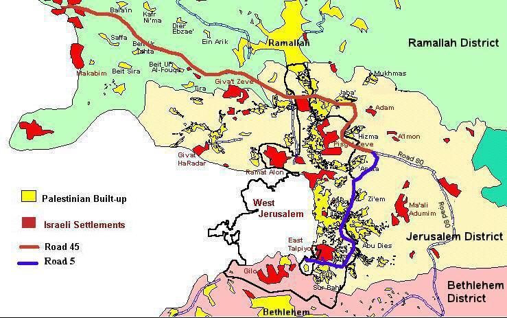
In continuation with its plans to separate Jerusalem from the remainder of the West Bank, Israel has begun to implement a new project aimed at constructing a ring road around the city of Jerusalem. This road, consisting of Roads 45 and 5, will connect the Israeli settlements in the southern part of Jerusalem with those in the northern part, as well as connecting Jerusalem's settlements with the coastal area of Israel.

The ring road, according to the construction plans which were finalized by the Israeli Morieh company in 1996, originates from the main Hebron-Jerusalem road at the southern entrance of Talpiyot. It extends eastwards to reach El-Swahreh and El-Sharqiua village, passing through the northern edge of Sur Bahir. The road continues northwards until it crosses the Jerusalem-Ramallah road near the Jerusalem airport. This particular section of the road approximately follows the expanded East Jerusalem boundaries of 1967. The ring road further extends northwest, passing through agricultural lands from many Palestinian villages in the Jerusalem and Ramallah districts, to end at the Beit Shemen Junction in the coastal area of Israel near the Lod (Ben Gurion) airport (Map 1 and 2).

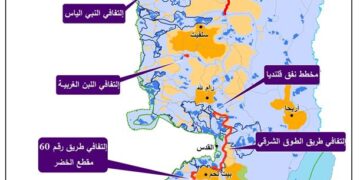
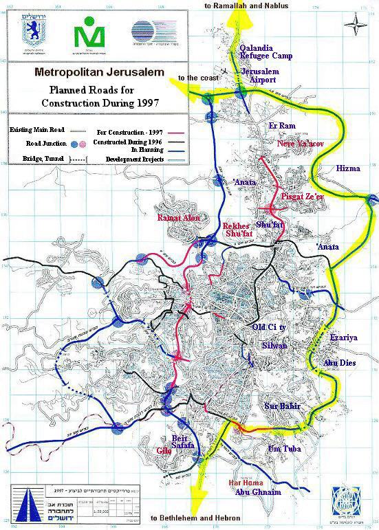
Map 1: The Planned Route of the Ring Road 


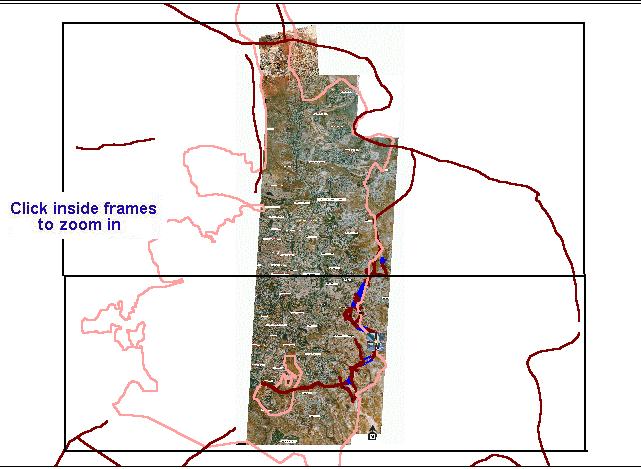
Map 2: The Ring Road – from Aerial photos

The ring road, will connect with the proposed Har Homa Settlement (Abu Ghnaim) and with the Ma'ale Adumim settlement. It will also connects with the Jerusalem-Jericho and Jerusalem-Ramallah roads. The road plans also includes three tunnels, the largest of which is 1.8 kilometers in length which will pass under Abu Dies village, emerging near Zi'em village (Map 2a). A second tunnel will pass under the Jerusalem airport and connect with the main Jerusalem-Ramallah road (Map 2b).

According to construction plans, the ring road necessitate the demolition of approximately 38 Palestinian homes, all of which are located in the Es-Sawahreh Esh Sharqiua, Abu Tur and Abu Dies areas (Map 2c, Map 2d, Map 2e). The road, which will stretch approximately 45 kilometers in the West Bank including East Jerusalem, will result in the expropriation and destruction of over 700 hectares (1,750 acres) of Palestinian agricultural lands.

In addition to the extensive environmental damage, the ring road will create a new reality of political separation and territorial discontinuity. According to many Israeli Knesset members, the ring road is 'designed to prevent territorial contiguity between a number of Palestinian villages in the Ramallah area. In addition, it will also keep the Jerusalem neighborhoods of Neveh Ya'acov and Pisgat Ze'ev from being completely encircled -and, in a worst case scenario, cut off – by Palestinian villages and neighborhoods.' (The Jerusalem Post, Friday 21 February 1997).

The ring road will reserve large stretches of land for the expansion of Israeli settlements in Jerusalem, especially Pisgat Omer, Pisgat Ze've, and Neve Ya'acov. Approximately 153 hectares of land have been recently confiscated from the land of neighboring village of Anata for this purpose. It will also create a physical barrier to the contiguity of Palestinian towns and villages. Similar to the military fenced road that Israel is constructing north of Bethlehem city, the ring road may prevent Palestinians from traveling between Jerusalem and Ramallah. It will furthermore separate the villages and towns of Abu Dies, Hizma, Jaba', Mukmas, Zi'em, Qalandia, and Rafat from Jerusalem (Map 1).).

Roads 45 and 5 are only a part of an extensive Israeli road network that will physically encircle Jerusalem and separate East Jerusalem from the rest of the West Bank. The planned bypass road number 4 is another part of this network. Map 3 shows roads which are proposed and under construction in the Jerusalem area.


Map 3: Planned Roads in the Jerusalem Area (Map adapted from the Israeli Ministry of Information Homepage).  


Prepared by:
The Applied Research Institute – Jerusalem

Recommended For You

​الطرق الالتفافية الإسرائيلية: “مشنقة مشروع حل الدولتين”

by arij
July 21, 2025
0
​الطرق الالتفافية الإسرائيلية: “مشنقة مشروع حل الدولتين”

مقدمة: اختلف الشكل العام لشبكة الطرق في الضفة الغربية تبعا للظروف السياسية والعسكرية التي مرت بها المنطقة، فحتى العام 1967 كانت شبكة الطرق في الضفة الغربية عبارة عن...

Read moreDetails

شق طريق استيطاني جديد يهدد سبل العيش في قرية بردلة

by arij
January 13, 2025
0
New Israeli Settlement Road Construction and Its Impact on the Village of Bardala in the Jordan Valley

المكان: تجمع بردلة- محافظة طوباس/الأغوار الزمان: سبتمبر 2024 الجهة المتضررة: أهالي قرية بردلة والقرى المجاورة الجهة المعتدية: ما تسمى بالإدارة المدنية الاسرائيلية الانتهاك: شق طريق استيطاني تفاصيل الانتهاك:...

Read moreDetails

New Israeli Settlement Road Construction and Its Impact on the Village of Bardala in the Jordan Valley

by arij
December 31, 2024
0
New Israeli Settlement Road Construction and Its Impact on the Village of Bardala in the Jordan Valley

  The construction of new settlement infrastructure in the occupied Palestinian territories has profound implications for local communities, threatening livelihoods, increasing isolation, and impairing socio-economic vulnerabilities. This case...

Read moreDetails

الطرق الالتفافية الاسرائيلية وأثرها على البيئة الفلسطينية

by arij
January 16, 2024
0
الطرق الالتفافية الاسرائيلية وأثرها على البيئة الفلسطينية

  الاعتداءات الإسرائيلية على الفلسطينيين لا تقتصر على التنكيل بالافراد، أو وضع القيود على الحركة والتنقل، أو استهداف المنازل والمنشات، أو مصادرة الأراضي، أو نهب الموارد والمصادر الطبيعية،...

Read moreDetails

Israeli Colonists Take Over an Agricultural Road in Ya’bad town / Jenin Governorate

by arij
January 12, 2022
0
Israeli Colonists Take Over an Agricultural Road in Ya’bad town / Jenin Governorate

  Violation: Taking over an agricultural road for the favor of colonization. Location: Ya’bad town / Jenin Governorate. Date: October 17th 2021. Perpetrators: Mevo Dotan Colony. Victims: Farmers...

Read moreDetails
Next Post
Eviction of the Inhabitants of Froush Beit Dajan

Eviction of the Inhabitants of Froush Beit Dajan

LATEST NEWS

” المواقع الأثرية في محافظة نابلس… ساحة مفتوحة أمام مخططات المصادرة الإسرائيلية “

” المواقع الأثرية في محافظة نابلس… ساحة مفتوحة أمام مخططات المصادرة الإسرائيلية “

by arij
August 21, 2025
0

........................................................

مشروع (E1): الضربة القاضية لحل الدولتين وإعادة تشكيل الخريطة الجيوسياسية للضفة الغربية

The Government Pushes Forward Plans in E1, Considered a Death Blow to the Two-State Solution

by arij
August 16, 2025
0

........................................................

مشروع (E1): الضربة القاضية لحل الدولتين وإعادة تشكيل الخريطة الجيوسياسية للضفة الغربية

مشروع (E1): الضربة القاضية لحل الدولتين وإعادة تشكيل الخريطة الجيوسياسية للضفة الغربية

by arij
August 16, 2025
0

........................................................

بواقع 86 أمرا عسكريا – الأوامر العسكرية الإسرائيلية, الأداة الرئيسية للاحتلال الاسرائيلي للسيطرة على المياه الفلسطينية في الضفة الغربية المحتلة

“سيطرة من تحت الأرض”, بواقع 108 أمرا عسكريا, سيطرة اسرائيلية على مياه الفلسطينيين في الضفة الغربية المحتلة

by arij
August 12, 2025
0

........................................................

flag_yellow_lowEU-PfP-Logo

This website has been produced with the assistance of the European Union. The contents of this publication are the sole responsibility of ARIJ & LRC and can in no way be taken to reflect the views of the European Union.

© 2025 Copyright ARIJ . All Rights reserved. .

No Result
View All Result
  • Home
  • Settlements
    • New Israeli Settlements
    • Settlement Expansion
  • Israeli Violations
    • Agriculture
    • Confiscation
    • Demolition
    • Environment
    • Eviction of Palestinians
    • Settlers Attacks
  • Bypass Roads
  • Israeli Plans
  • Segregation
    • Checkpoints
    • Closure
    • Separation Plans
  • Military Orders
  • Reports
    • Daily Report
    • Monthly Report
    • Quarterly Report

© 2025 Copyright ARIJ . All Rights reserved. .