A New Section of the Segregation Wall is being constructed in Azzun Atma
Location and Population The village of Azzun Atma is a Palestinian village that was occupied in...

El Muro De Segregacion Israeli, aislamiento y de guetización en la Terra Santa
El 30 de abril de 2006 el gobierno israelí aprobó un plan revisado para el muro...
Trapped between walls
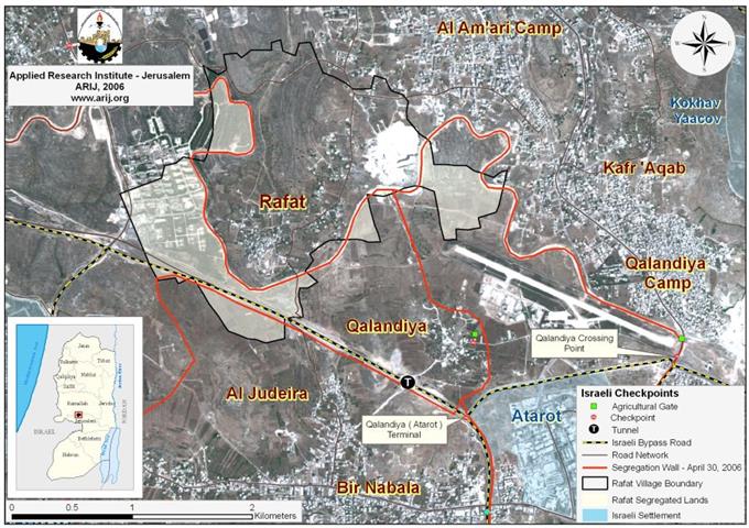
Rafat, another victim of the Israeli Segregation Wall
Location and Population The Palestinian village of Rafat lies 16 kilometers north of Jerusalem city and...
The Israeli Outposts Evacuation Game
The Israeli Government’s Intention to Evacuate the Settlement’s Outposts, between the Lack of Seriousness and Postponement!!!
Introduction On October 6, 2006, the Israeli Defense Minister A'meer Peretz declared the Israeli Army is...
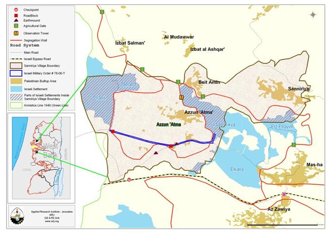
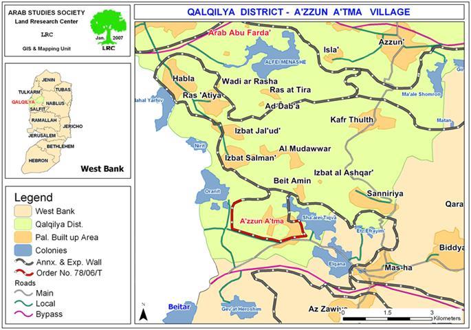
New Stage for completing the Segregation wall around ‘Azzun ‘Atma village in Qalqilyia
'Azzun 'Atma : location and Population The village of 'Azzun 'Atma (population 1791-PCBS 2005) is...
ARIJ Fact Sheet
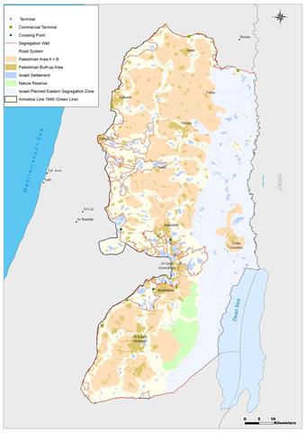
Israel’s Segregation Wall: Isolation and Ghettoization in the Holy Land
On February 20, 2005 the Israeli government approved a revised plan for the Segregation Wall in...

In challenge of High Court decision Resumption of Wall works around the settlement of Karmei Zur
(Photo 1: Israeli bulldozers work in Palestinian land near Karmei Zur settlement) On Thursday August...
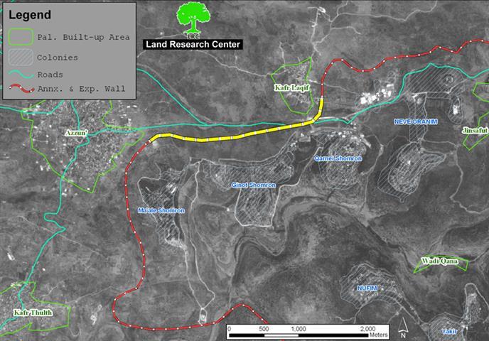
Resumption of Wall construction in the biggest finger-like corridor in the West Bank
(Photo 1: the yellow section of the Wall currently under construction) The Israeli army bulldozers resumed...
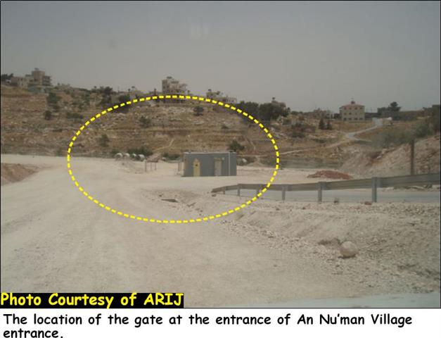
An Nu’man village turned into an open air prison
The Israeli occupation authority, as part of its segregation Wall plan for the northwestern Bethlehem area,...
New Palestinian Enclaves created by the Israeli updated wall map around Ariel Settlement Bloc.
The Israeli Government endorsed on April 30, 2006, an updated Wall plan which included changes in...
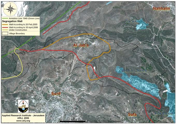
The new changes on the Segregation Wall path in Al Jab’a village
A glance about Al Jab'a village Al Jab'a is a Palestinian village located 12.5 Kilometers...
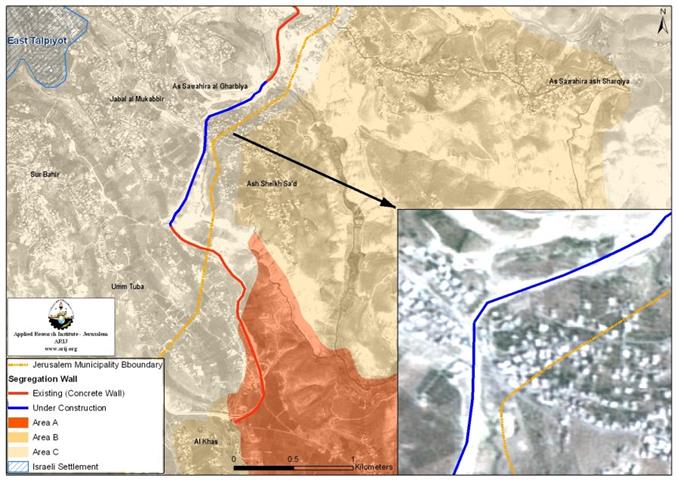
The Israeli Appeal Court voids section of the Separation Barrier in Sheikh Sa’ed Neighborhood, East Jerusalem !
Sheikh Sa'ed village is located on the eastern outskirts of Jerusalem with a population...
New Wall changes confiscates more lands from Al Walajeh Village !
On April 30th, 2006 the Israeli Ministry of Defense issued on its website an updated...
New updated Wall path in Battir Village – Bethlehem Governorate !!
Battir village lies adjacent to the Armistice line (Green Line) and is located 6...
Israeli Wall activities in the vicinity of Rachel’s Tomb !
On Thursday, the 27th of April 2006, the Israeli bulldozers backed by police guards resumed...
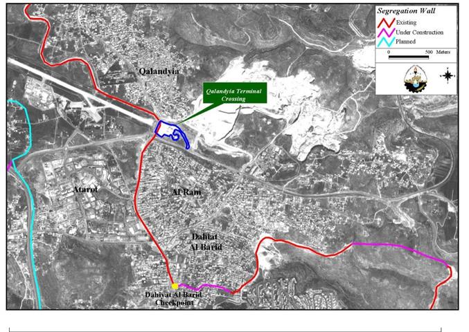
Israeli High Court Rejects Appeal of Al-Ram Residents to keep Access to Jerusalem open
In the appeal to the Israeli High, Court with regard to the Israeli Segregation Wall...
The enclavement of Al Walajeh Village
Al-Walajeh Village is located 8.5 km to the southwest of Jerusalem city, and about...
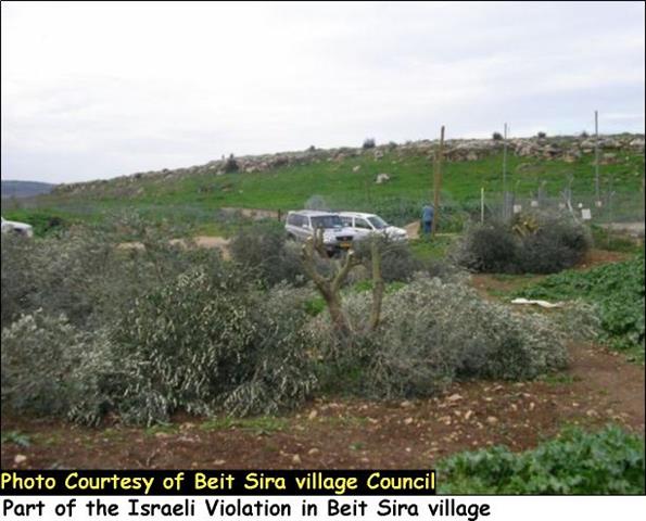
The Israeli aggressive measures continue in Beit Sira village
Beit Sira is a Palestinian village located 15 Km to the southwest of Ramallah Governorate....
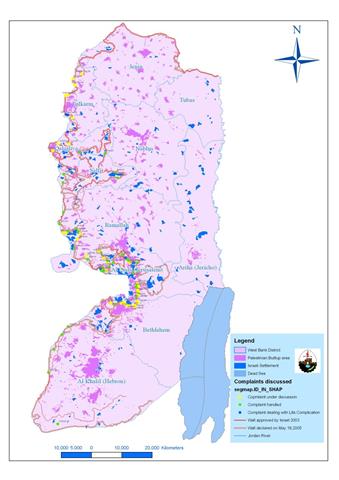
Wall cases are still pending at Israeli Court
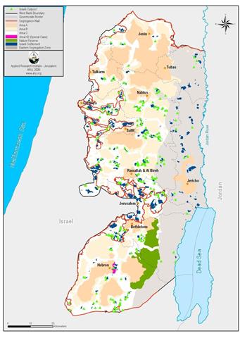
Prelude In 2002, the Israeli Government adopted a plan to construct a system of walls...
Al Lubban Al Gharbi Village feels the threat of the Israeli Segregation Wall
Location Al Lubban Al Gharbi is a small village, located approximately 21 kilometers northwest...
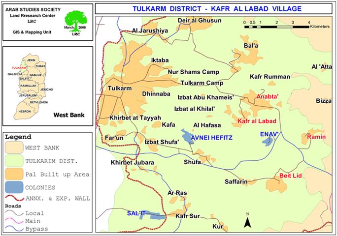
The Israeli occupation starts to build the Segregation Wall around the settlement of Enav
The Israeli occupation forces started on March 2nd, 2006, to destroy and uproot thousands of...
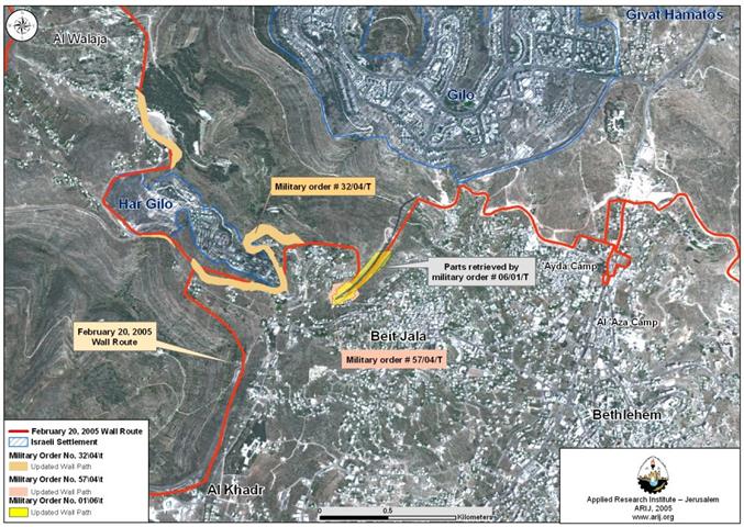
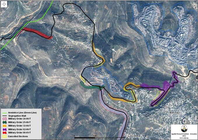
Israel remodels wall sections in Beit Jala City
The Israeli Occupation forces handed out residents of Beit Jala city a new military order...
The Rachel’s Tomb area is undergoing final wall constructions
The Israeli bulldozers are back to Rachel's Tomb area to continue with Wall constructions planned...
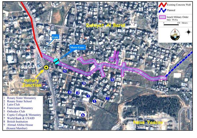
Enclaving Dahiyet Al Barid and Al Ram Territories !
On November 30, 2005, the Israeli court issued an updated map of the Wall section in...
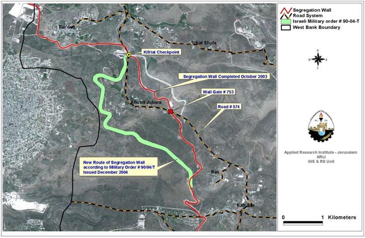
Jubara … A Prototype Aftermath of the Israeli Segregation Wall
On February 29, 2005, the Israeli Army released the finale diagram of the so-called security fence...
LATEST NEWS

تهويد صامت بالأمتار: الطريق إلى بني كيديم خطوة نحو الشرعنة الاستيطانية
........................................................

من غير شرعية إلى واقع مفروض, البؤرة الاستيطانية سدي بوعز في رعاية الاحتلال
........................................................
حين تضيق الأرض: غزة الأعلى كثافة سكانية في العالم
........................................................

ملاخي هشالوم: أكثر من مجرد بؤرة استيطانية … مشروع تهويد وتوسّع اسرائيلي
........................................................
