- Violation: arson attack.
- Location: Saffa and Bal’in/ Ramallah governorate
- Date: Oct 9th 2020.
- Perpetrators: “Kiryat Sefer” settlement.
- Victims: Farmers of Saffa and Bala’in.
Description:
Olive trees are a symbol of land Arabism, it reflects the lands’ Palestinian identity, Palestinian farmers patiently wait for the olive harvesting season.
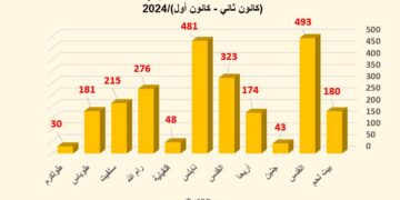
According to eyewitnesses, Friday October 9th 2020 about 11:00 am , a group of extremist settlers from Kiryat Sefer settlement raided the olive groves area behind the Annexation and Expansion Wall , and set fire in olive groves at several locations, the flames ate up 300 dunums (1200 olive trees) , the arson attack took place in several locations such as “Wad Al-Malaqi” , “Baten Hraiz” , “Al-Kersaneh”, “Baten As-Sanam” , and “Al-Quma’a” areas of Safa and Bala’in villages.


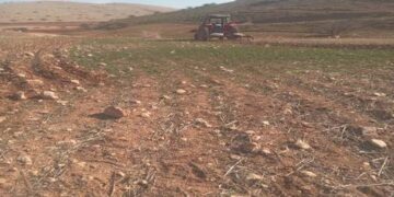
Photos 1-7: The Fire damages

Safa village Council head Ahmad Samara told LRC:
“After seeing flames eating up olive groves behind the Annexation and Expansion Wall, farmers of the village and owners of olive groves hurried to the wall gate, but the occupation forces prohibited them from passing through to turn off the fire, the only option they had was to call the International Committee of the Red Cross who tried to speak with the Israeli Authorities , but on the ground the occupation forces were still refusing to open the gate or even let Palestinian Fire Fighters in . The Occupation forces called an aircraft to combat the fire only around Kisryat Sefer settlements, while it was left to eat Olive groves.”
The village Council head asserted that this is the third arson attack only during the last two years.
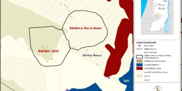
Establishing a new outpost:
Few months ago, Israeli settlers established a new outpost and named it “Me’ora” on private Palestinian lands behind the Annexation and Expansion wall, the new outpost is only 1 km away from “Kiryat Safer” and built on a plot that belongs to Mansour family who filed a lawsuit against the perpetrators, but the case is cold by now. While the settlers of the new outpost received support from the Israeli government to grow and develop.
 Photo 8: The new outpost
About Saffa[1]:
17 km to the west of Ramallah , Saffa is bordered by Bil’in and illegal colonies (Kiryat Sefer / Matityahu/Hashmonaim) built on confiscated lands to the north, The Occupied territories (1948) or the greenling , illegal colonies (Kfar Ha-Oranim , Shelta, Kfar Rut) to the west , Kafr Ni’ma , Deir Ibzi , Beit Ur Al-Tahta to the east , Kharabatha Al-Misbah and Beit Sira “Maccabim” illegal colony to the south.
Saffa has a total population of (4,374) people, according to 2017 census.
Saffa has a total area of 14,248 dunums , of which 725 are a built up area.
The Occupation confiscated 4834 dunums of Saffa lands for the following purposes :
- Israeli Colonies devoured 3974 dunums as follows:
|
Colony name |
Establishment year |
Area in dunums |
Number of colonists |
Colony area |
|
Kfar Ruth |
1977 |
1249 |
N/A |
1249 |
|
Maccabim |
1982 |
304 |
N/A |
1758 |
|
Kiryat Sefer |
1991 |
11 |
74615 |
3914 |
|
Hashmonaim |
1985 |
6 |
3270 |
1075 |
|
Shelta |
1977 |
970 |
N/A |
983 |
|
Kfar Ha-Oranim |
1998 |
810 |
2508 |
810 |
|
Lubaid |
1996 |
438 |
N/A |
438 |
|
The planned industrial area |
1982 |
186 |
N/A |
287 |
- Bypass roads ( 443 /446) devoured 425 dunums , the road was built behind the apartheid wall (in the isolated area between the wall and the green line).
- The Annexation and Expansion Wall about 435 dunums , and isolated 8086 dunums.
Oslo accords divided the town’s lands as follows:
- B area : (1,762) dunums.
- C area: (12,486) dunums.
[1] GIS-LRC
The Land Research Center
LRC