- Violation: Colonial expansion.
- Location : Iskaka village / Northeast Salfit.
- Date: April 24th 2020.
- Perpetrators: Settlers of “Nofei Nehmeia”.
- Victims: Number of farmers from the village.
Description:
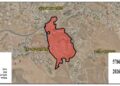
Friday, April 24th 2020 , settlers continue ravages around “Nofei Nehmeia” outpost on confiscated lands from Iskaka village northeast Salfit, according to the Palestinian Liaison Office : “ Settlers operated machineries to level areas of Palestinian agricultural lands that surround “Nofei Nehmeia”, in the intention to expand it and set up a fence around it .until the day of preparing this report , 7 dunums were leveled in natural block 15 in “Al-Qinya” site of Iskaka village lands.”
Reportedly, illegal settlers ravaged 4 dunums owned by farmers from Iskaka village lands, under the darkness of the night in February 2020 . For more information read LRC report (Arabic report , English report).
The targeted location is only 400 m away from citizens houses in Iskaka and Yasouf , it was used in the past for growing a variety of field crops , since the year 2000 to this day , the occupation have been prohibiting Palestinian owners from cultivating this land.
The targeted lands belong to : heirs of Abdulqader Harb, heirs of Abdulraheem Harb , Nathmi Harb, Mohsen Harb.
Noteworthy, “Nofei Nehmeia” outpost was established in 2003 , a group of “Rehalim” settlers put their hands on a plot registered in the occupation authorities’ records as an Israeli state property.
The fanatic settlers set up number of tents in the plot, and started carrying out violations and attacks against Palestinians in nearby locations , then they started bringing in mobile houses, and in 2009 the occupation opened a colonial road that serves the outpost. Now while the world is occupied with the corona pandemic and under a radical rightist government , settlers try to legalize their colonial activities in the West Bank .
About Iskaka: [1]
Iskaka is located 6 km to the northeast of Salfit city and is edged by Jamma’in village from the north, Salfit city from the west, Ariel colony from the west and Shevut Rahel colony from the east.
Its population mounts up to 1198 people (2017 census). Iskaka’s total land area is 5474 dunums, of 217 dunums are considered the village’s built-up area.
Israeli colonies confiscated 257 dunums from Iskaka lands. Ariel colony that was established in 1978 confiscated 198 dunums from the village.
Bypass roads confiscated around 40 dunums from the village.
The lands of Iskaka are classified according to Oslo Accords as the following:
- 1491 dunums (27%) are classified as area B
- 3983 dunums (73%) are classified as area C
[1] GIS-LRC
The Land Research Center
LRC