• About The Project
  • Palestine in Century
  • Selected Maps
  • Glossary
  • About ARIJ
  • About LRC
  • By Year
    • Case Studies By Year
    • Daily Report By Year
Saturday, March 7, 2026
POICA
No Result
View All Result
  • Home
  • Settlements
    • New Israeli Settlements
    • Settlement Expansion
  • Israeli Violations
    • Agriculture
    • Confiscation
    • Demolition
    • Environment
    • Eviction of Palestinians
    • Settlers Attacks
  • Bypass Roads
  • Israeli Plans
  • Segregation
    • Checkpoints
    • Closure
    • Separation Plans
  • Military Orders
  • Reports
    • Daily Report
    • Monthly Report
    • Quarterly Report
No Result
View All Result
POICA
No Result
View All Result

The Israeli occupation lay their hands on a plot in Dura/ Hebron Governorate

October 12, 2019
in Military Orders
The Israeli occupation lay their hands on a plot in Dura/ Hebron Governorate


  • Violation: confiscating 129 dunums.
  • Date: 23/09/2019
  • Location: Hadab Al-Fawwar- Dura village / Hebron governorate.
  • Perpetrator: The Israeli occupation civil administration.
  • Victims: Al- Harbiyat family.

Description:

The Israeli occupation authorities announced imposing control over wide areas of Dura lands south Hebron.

Monday 23 September 2019, The Palestinian Liaison Office in Dura received a notice from the occupation authorities and civil administration -the responsible on government properties, entitled “Modifying borders of government properties”.

Photo 1-2 : the occupation’s announcement

An aerial photography

The announcement was issued in 09/09/2018 states that in 1987 the Responsible on government properties signed a deed announcing that the area belongs to the state , The blue line[1] committee in the civil administration completed the mission in 31st July 2019, and pointed out that the targeted lands are in natural block 8 in Al-Hadab location east Yatta.

The targeted plot is located to the east of Dura town close to Hadab Al-Fawwar area , east Be’er Sheva – Hebron road , and belong to Al-Hribat family.

In 1987 the occupation authorities took over the location which has an area of (115) dunums , after reviewing the plot by the so called blue line committee (8 dunums) were released, while 22 dunums were annexed , the total area becomes (129) dunums.

The occupation army had a military camp on the top of the “White mount”, west of the targeted lands , Palestinians of the area are worried from the continuous colonial expansion on these lands , especially that they have “Adoraym” camp close to the area , where the occupation forces carry out trainings .

It is also important to mention that he occupation forces launched a campaign between (1982 -1989) and confiscated vast areas of West Bank lands , and transformed  800 thousand dunums of privately owned Palestinian lands into Israeli state properties , most of them were used in Colonization.

Noteworthy, in 28/06/1987 , the responsible on government properties in the civil administration signed a deed attached with a map that announces three plots with a total area of (1500 dunums) as state property in the eastern area of Dura village. In the new military order, the occupation targeted one out of the three plots .

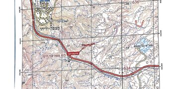
Photo 4: the attached map in 1987 military order

[1] The blue line committee is a staff in the civil administration that is entrusted with a task of surveying lands, and studying maps of state properties and modifying their borders.


Prepared by

 The Land Research Center
LRC

Recommended For You

سلطات الاحتلال الإسرائيلي تستخدم الأوامر العسكرية لتعمق المشروع الاستيطاني في الضفة الغربية المحتلة

by arij
February 26, 2026
0
سلطات الاحتلال الإسرائيلي تستخدم الأوامر العسكرية لتعمق المشروع الاستيطاني في الضفة الغربية المحتلة

تقديم منذ احتلال الضفة الغربية عام 1967، اعتمدت سلطات الاحتلال الإسرائيلي منهجية واسعة عبر استخدام الأوامر العسكرية كأداة "قانونية" لفرض الوقائع الجغرافية والديموغرافية على الأرض الفلسطينية. وأصبحت هذه...

Read moreDetails

بين مطرقة الأوامر العسكرية وسندان التقييد الجغرافي, أوامر عسكرية إسرائيلية جديدة تطال أكثر من 1000 دونم في طوباس

by arij
November 26, 2025
0
بين مطرقة الأوامر العسكرية وسندان التقييد الجغرافي, أوامر عسكرية إسرائيلية جديدة تطال أكثر من 1000 دونم في طوباس

في الحادي والعشرين من شهر تشرين الأول لعام 2025، تسلّم أهالي محافظة طوباس سلسلة من الأوامر العسكرية الإسرائيلية التي استهدفت مساحات واسعة من الأراضي الفلسطينية في المحافظة. وقد...

Read moreDetails

“ما يزيد عن 25 ألف دونم من أراض الزيتون”,
موسم الزيتون في فلسطين تحت رهن الأوامر العسكرية

by arij
March 4, 2026
0

نشرت سلطات الاحتلال الإسرائيلي في الثاني والعشرين من شهر تشرين أول من العام 2025 مجموعة من الأوامر العسكرية والتي استهدفت مساحات شاسعة من الأراضي الفلسطينية في محافظات الضفة...

Read moreDetails

ما يزيد عن 1900 دونما من الأراضي الفلسطينية في بيت لحم مهددة بالعزل لصالح مستوطنة افراتا

by arij
October 8, 2025
0
ما يزيد عن 1900 دونما من الأراضي الفلسطينية في بيت لحم مهددة بالعزل لصالح مستوطنة افراتا

في الثاني من شهر تشرين أول من العام 2025، أصدرت سلطات الاحتلال الإسرائيلي أمرًا عسكريًا جديدًا يحمل الرقم (ت/3/25) تحت عنوان "تعديل حدود – يهودا والسامرة، 5785-2025". ويأتي...

Read moreDetails

سلطات الاحتلال الإسرائيلي تستغل ‘المنفعة العامة’ لنهب الموارد الفلسطينية

by arij
September 30, 2025
0
سلطات الاحتلال الإسرائيلي تستغل ‘المنفعة العامة’ لنهب الموارد الفلسطينية

في الاول من شهر ايلول من العام 2025، نشرت الإدارة المدنية الإسرائيلية، الذراع الأيمن لحكومة الاحتلال الإسرائيلي أمرا عسكريا جديدا تحت عنوان " أمر ءبشأن قانون الأراضي (الاستملاك...

Read moreDetails
Next Post
The Israeli occupation lay their hands on a plot in Dura/ Hebron Governorate

الاحتلال يستولي على أراضي في بلدة دورا ويعلنها أراضي دولة / محافظة الخليل

LATEST NEWS

سلطات الاحتلال الإسرائيلي تستخدم الأوامر العسكرية لتعمق المشروع الاستيطاني في الضفة الغربية المحتلة

سلطات الاحتلال الإسرائيلي تستخدم الأوامر العسكرية لتعمق المشروع الاستيطاني في الضفة الغربية المحتلة

by arij
February 26, 2026
0

........................................................

تسجيل الأراضي أم الضم عبر السجل؟ الرهانات القانونية والسياسية لتسوية الملكيات في الضفة الغربية

تسجيل الأراضي أم الضم عبر السجل؟ الرهانات القانونية والسياسية لتسوية الملكيات في الضفة الغربية

by arij
February 26, 2026
0

........................................................

حين تتقلص الخريطة: تسارع غير مسبوق في توسّع المستوطنات الإسرائيلية خلال عام 2025

حين تتقلص الخريطة: تسارع غير مسبوق في توسّع المستوطنات الإسرائيلية خلال عام 2025

by arij
February 16, 2026
0

........................................................

الضفة الغربية بين إرهاب المستوطنين وتواطؤ الاحتلال – حصيلة العام 2025

الضفة الغربية بين إرهاب المستوطنين وتواطؤ الاحتلال – حصيلة العام 2025

by arij
February 16, 2026
0

........................................................

flag_yellow_lowEU-PfP-Logo

This website and its content were initiated in 1993 by the Applied Research Institute – Jerusalem (ARIJ) and the Land Research Center (LRC) with the support from the European Union up until 2023. Since then, the Applied Research Institute – Jerusalem (ARIJ) has taken over the continued development and maintenance of the website. The views expressed remain solely those of ARIJ) and do not necessarily reflect those of the European Union.

© 2026 Copyright | ARIJ | All Rights reserved.

No Result
View All Result
  • Home
  • Settlements
    • New Israeli Settlements
    • Settlement Expansion
  • Israeli Violations
    • Agriculture
    • Confiscation
    • Demolition
    • Environment
    • Eviction of Palestinians
    • Settlers Attacks
  • Bypass Roads
  • Israeli Plans
  • Segregation
    • Checkpoints
    • Closure
    • Separation Plans
  • Military Orders
  • Reports
    • Daily Report
    • Monthly Report
    • Quarterly Report

© 2026 Copyright | ARIJ | All Rights reserved.