- Violation: Setting up a metal gate and halting work on an agricultural road.
- Location : Umm Safa village / North Ramallah city.
- Date: 09/09/2019.
- Perpetrator: The Israeli occupation army.
- Victims: People of Umm Safa.
Description:
Monday , August 12th , The Israeli occupation army raided Al-‘Ayin area south-west Umm Safa north Ramallah city , the targeted area is located to the south of bypass 465 that penetrates the village and links settlements of the area.
Noteworthy, the Israeli occupation building organization officer in the civil administration put a military order under a rock to the side of an agricultural road called “Al-‘Ayin” that was rehabilitated with the support of the ministry of agriculture with funding from Al-Fao at the beginning of this year.
According to military order number (00292) the occupation set September 02 as the building and organization session in Beit El military court to decide the fate of the structure.


Umm Safa village council head “Marwan Sabah” told LRC reporter:
“The targeted road is (1.5 km * 4m) , the road was ready for base course , but hindered by the occupation’s military order , it was supposed to serve about 200 dunums of olive groves.”
Sabah asserted: “Once we received military orders we hired JLAC to follow up the case in the occupation’s court , and they told us recently that the occupation refused to license our structures , but we are determined to continue our works , as it affects wide areas of agricultural lands that are targeted by colonization.”
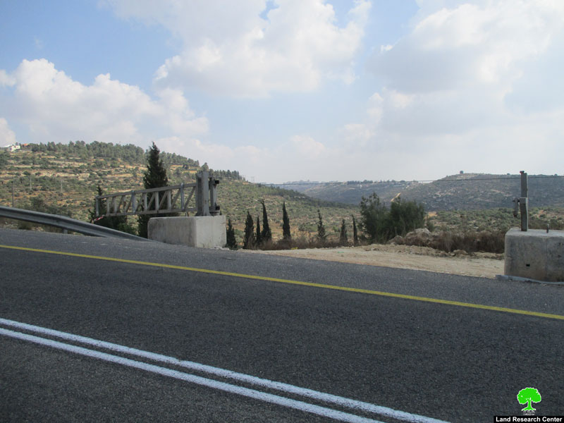
Setting up a metal gate on “Al-‘Ayin” road :
Just in time with the court resolution to refuse licensing procedures , the Israeli occupation forces set up a metal gate on “Al-‘Ayin” agricultural road . Noteworthy , this road links the targeted road to the bypass that penetrates the village. By this, the occupation imposes their control over the village.
Village council head told LRC reporter:
“The occupation aim is to impose control over the area including the cemetery, a group of settlers put signs all over the place leveling to take over it , but the locals’ efforts foiled their scheme.”
About Umm Safa village:[1]
Umm Safa is located about 12 km to the north of Ramallah , the village is bordered by ‘Ajoul and ‘Atara (east) , ‘Ajoul and Deir Sudan (north) , Deir Nitham and An-Nabi Saleh (west) and Burham , Jibya and Kubar (south).
Umm Safa has a population of 670 people , until 2017 census , from many families such as : Tanatra , Sabah, Misleh, ‘Arqub, Bahar, Qanneh and Mohammad.
Umm Safa has a total area of 4403 dunums , of which 93 dunums are a built up area, the Israeli occupation confiscated 230 dunums for “‘Aterat” and “Halmish” illegal settlement that devoured parts of the town’s lands.
[1] GIS-LRC
Prepared by


