- Violation: ravaging an agricultural road.
- Location: North Deir Ghassana village/ Ramallah Governorate.
- Date: 12/06/2019.
- Perpetrator: The Israeli occupation forces.
- Victims: People of the village.
Description:
Wednesday, 12th June 2019, The Israeli occupation forces raided “Ein Az-Zarqa’” area north west Deir Ghassana village, where the occupation forces dig a ditch in an agricultural road rehabilitated recently which destroyed number of water pipes beneath the road.
About the targeted road, Engineer Saed ‘Ubaid head of the engineering department in Bani Zaid Al-Gharbiya municipality told LRC the following:
“early this year , Bani Zaid Al-Gharbiya municipality carried on rehabilitating an agricultural road (6 km* 6 m) with a budget of 50,000 $, the road connects Deir Ghassana village to Ein Zarqa area , it serves about 1500 dunums planted with olive groves and belong to farmers from Deir Ghassana and Beit Rima, it also leads to several beautiful natural sites, opening the road revived the area , people of the village started going there to enjoy fresh air and the beautiful view, which disturbed the occupation that wants to keep it a colonial reserve. In June 12 we were shocked of the occupation forces digging a segment of the road which also sabotaged number of water pipes without any excuses or preceding notices, while settlers were provided with facilitations to access the area. Noteworthy , Beit Areh settlement is only one kilometer away from the settlement.”
‘Ubaid asserted: “The road rehabilitation project came in coordination with the ministry of agriculture in coordination with Union of agricultural work committees and funded by the European Union.”

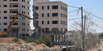
 Photos 1+2: the targeted road surrounded by agricultural lands
 |
 |
 |
 |
 |
 |
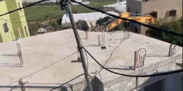
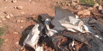
Photos 3-8: the road after the attack

Noteworthy, this attack is the second of this sort in one year , last April , Bani Zaid Al-Gharbiya municipality in coordination with the Palestinian Hydrologists group to rehabilitate Ein Az-Zarqa spring with water taps and tunnels , but the occupation forces destroyed them on the pretext of assaulting a natural reserve as the Israeli occupation descried it. In 2017 the occupation closed Ein Az-Azrqa natural reserve, also settlers made several attempts to take over it.
Ein Zarqa natural reserve has a historical, economical and agricultural significance to Deir Ghassana , Bani Zaid Al-Gharbiya and Deir Ballut towns, it is also a significant location for tourists , but the occupation is trying to take over it under claims that it is a state property according to Oslo accords.
Deir Ghassana village:
Deir Ghassan is located in Bani Zayed Al-Gharbiya community, which contains Deir Ghassana and Beit Rima and placed 25 km north west Ramallah, it is surrounded by Bruqin and Kafr Ad-Deek (north) , Al-Lubban Al-Gharbi (Beit Aryeh settlement) (west) , Kafr Ein (east) and Beit Rima (south).
Deir Ghassana has a total population of (1692) people, according to 2017 census.
Bani Zayed Al-Gharbiya community has a total area of 21,978 dunums , of which 394 dunums are a built up area for Deir Ghassana , and 848 dunums are a built up area for Beit Rima.
The Israeli occupation confiscated about 1000 dunums of Deir Ghassana lands for the following purposes:
- Bypass 446 devoured (780 dunums).
- The apartheid wall (siege) , which is 1,526 m, ate up (135) dunums under its route , and isolated 812 dunums.
Oslo accords divided Bani Zayed Al-Gharbiya community as the following:
- A area : (6,407) dunums.
- B area: (8,452) dunums.
- C area : (7,119) dunums.
Prepared by