• About The Project
  • Palestine in Century
  • Selected Maps
  • Glossary
  • About ARIJ
  • About LRC
  • By Year
    • Case Studies By Year
    • Daily Report By Year
Thursday, October 2, 2025
POICA
No Result
View All Result
  • Home
  • Settlements
    • New Israeli Settlements
    • Settlement Expansion
  • Israeli Violations
    • Agriculture
    • Confiscation
    • Demolition
    • Environment
    • Eviction of Palestinians
    • Settlers Attacks
  • Bypass Roads
  • Israeli Plans
  • Segregation
    • Checkpoints
    • Closure
    • Separation Plans
  • Military Orders
  • Reports
    • Daily Report
    • Monthly Report
    • Quarterly Report
No Result
View All Result
POICA
No Result
View All Result

A Land Seizure orders targets the lands of Beit Sahour city <>

February 1, 2018
in Military Orders
A Land Seizure orders targets the lands of Beit Sahour city

On the 19th of January 2018, the Israeli Occupation Army (IOA) served Beit Sahour Municipality a new military order named ‘Land Seizure Order No. (17/35/T) which stipulates the confiscation of 1.344 dunums of lands of Beit Sahour city to rehabilitate and expand a military road for the use of the Israeli Army and settlers in Ush Ghurab area east of Beit Sahour. A copy of the military order is attached below


The following is a translation of the Israeli land seizure order no. (17/35/T): 

Israeli Defense Army

Land Seizure Order # (17/35/T)

According to my jurisdictions as a Military Chief Commander in the Region of Judea and Samaria, and as I believe that it is imperative for military purposes, I order the following: 

Key Terms 

1. In This Order: 

  • ''Map''– Map drawing scale of 1/ 3,500 signed by myself and considered inseparable part of the order at hand. 
  • The Lands : An area of land size of 1.344 dunums marked in red in the map illustrating the  land to be seized

Length

Width

Area (dunums)

Land Area

Block No.

Parcel

670 m

2m

1.344

Bethlehem

7

Al Beida

9

Wad Hilwa

Beit Sahour

27071

25-26-87-36-35-0

Note: 0.142 dunums of seized land comes part of a previously issued Israeli Land seizure  order No. 02/04/H as shown in the map

Land Seize

2. I declare that the above-mentioned lands seized for military purposes.

 Possession

3. The Israeli Defense Army declares absolute possession of stated lands and authorizes it to the land officer at the central command headquarters under the Ministry of Defense.

 Compensation Inquiries 

4. For inquiries regarding compensations, the landowners are to contact the District Coordination Office (DCO) in Bethlehem.

Issuance

5. Copies of the order at hand are to be delivered to the District Coordination Office (DCO) in Bethlehem who will in its turn pass the order on to the landowners. 

Allocation

6 (A)-1: All means to notify the Landowners of the land seizure; either through the District Coordination Office (DCO) in Bethlehem or other mean is considered valid.

 6 (A)-2: A tour/ meeting will be arranged through the District Coordination Office (DCO) in Bethlehem to tour the designated land.  

6 (B) Copies of the order at hand along with the attached map are to be located at the following places for public reference:

  • District Coordination Offices (DCO) in Bethlehem
  • Offices of the Judicial Advisor for the Region of Judea and Samaria
  • Office of the Ministry of Defense delegation officer at the civil administration
  • Office of the Chief of Infrastructure at the Israeli Civil Administration of Judea and Samaria
  • Office of the Absentee and public lands contact officer at the civil administration.

7. land owner are entitled to file an objection regarding the seizure order to the legal counselor through the District Coordination Office (DCO) in Bethlehem within 7 days of the tour (6 (A)-2) Above .

8.  The order will go in effect at the time of its signing to December 31, 2019

9. The order at hand will be identified as ''Land Seize Order # 17/35/T (Judea and Samaria) 2017-5777''. 

Roni Nomeh

Chief Commander of the Israel Defense Forces in Judea & Samaria
                                Signature


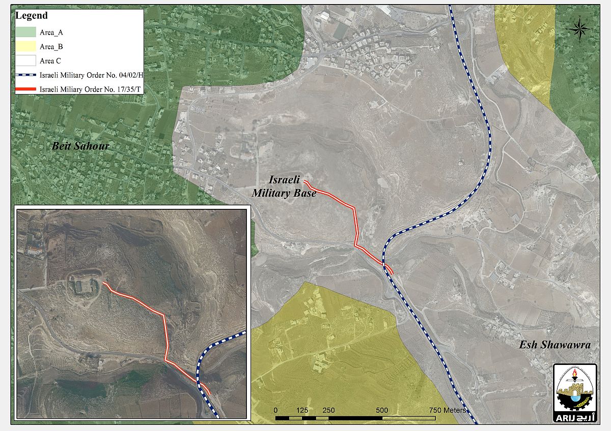
Analysis conducted by the Applied Research Institute – Jerusalem (ARIJ) of the attached military order map showed that the Israeli Occupation Army is planning to rehabilitate and expand a 0.670 km long road which runs from Ush Ghurab military site east of Beit Sahour and connects with the Israeli bypass No. 398 . See Map 1

Map 1: The Israeli Military Order No. 17/35/T


The rehabilitation of the road will further increase Israel’s control over the area and hints that Israel has no plans to relinquish or abandon the site or give it up to Palestinians for whatever purpose.

Additionally, several demonstrations and activities were held by different Israeli settlers groups during the past years in an attempt to re-occupy the site and build a Jewish community there after it was evacuated back in April 2006. A detailed report about Ush Ghurab site can be read HERE .


Prepared By  
The Applied Research Institute – Jerusalem
ARIJ

Recommended For You

سلطات الاحتلال الإسرائيلي تستغل ‘المنفعة العامة’ لنهب الموارد الفلسطينية

by arij
September 30, 2025
0
سلطات الاحتلال الإسرائيلي تستغل ‘المنفعة العامة’ لنهب الموارد الفلسطينية

في الاول من شهر ايلول من العام 2025، نشرت الإدارة المدنية الإسرائيلية، الذراع الأيمن لحكومة الاحتلال الإسرائيلي أمرا عسكريا جديدا تحت عنوان " أمر ءبشأن قانون الأراضي (الاستملاك...

Read moreDetails

The Occupation Targets the Village of Raba Southeast of Jenin with Military Orders and Seizes Vast Areas of Its Lands

by arij
September 13, 2025
0
الاحتلال يستهدف بأوامر عسكرية قرية رابا جنوب شرق جنين ويصادر مساحات واسعة من أراضيها

 The Israeli occupation Army have continued their policy of plundering Palestinian lands, as their bulldozers leveled wide areas of agricultural land in the village of Raba, southeast of...

Read moreDetails

الاحتلال يستهدف بأوامر عسكرية قرية رابا جنوب شرق جنين ويصادر مساحات واسعة من أراضيها

by arij
September 13, 2025
0
الاحتلال يستهدف بأوامر عسكرية قرية رابا جنوب شرق جنين ويصادر مساحات واسعة من أراضيها

  واصلت قوات الاحتلال الإسرائيلي سياسة نهب الأراضي الفلسطينية، حيث أقدمت آلياتها على تجريف أراض زراعية واسعة في قرية رابا جنوب شرق محافظة جنين، تمهيدا لشق شارع عسكري...

Read moreDetails

Nablus Governorate’s Archaeological Sites Face Israeli Expropriation Plans

by arij
September 11, 2025
0
” المواقع الأثرية في محافظة نابلس… ساحة مفتوحة أمام مخططات المصادرة الإسرائيلية “

On 10 August, 2025, the Israeli Civil Administration (ICA), issued a booklet of military orders signed by the head of the so-called ‘Israeli Civil Administration’ in the occupied...

Read moreDetails

” المواقع الأثرية في محافظة نابلس… ساحة مفتوحة أمام مخططات المصادرة الإسرائيلية “

by arij
August 26, 2025
0
” المواقع الأثرية في محافظة نابلس… ساحة مفتوحة أمام مخططات المصادرة الإسرائيلية “

في العاشر من شهر اب من العام 2025, أصدرت الإدارة المدنية الإسرائيلية كراسة أوامر عسكرية موقعة من قبل رئيس ما يسمى "بالإدارة المدنية الإسرائيلية" في الضفة الغربية المحتلة,...

Read moreDetails
Next Post

ARIJ Daily Report – Mon, 22nd 01 2018

LATEST NEWS

Annexation of the Jordan Valley: Implications for the Two-State Solution and Regional Stability

Annexation of the Jordan Valley: Implications for the Two-State Solution and Regional Stability

by arij
September 29, 2025
0

........................................................

Isolation of Three Villages Northwest of Jerusalem: Silent Annexation Creeps toward the Capital

عزل ثلاث قرى فلسطينية شمال غرب مدينة القدس: الضم الاسرائيلي الصامت يزحف نحو محيط العاصمة

by arij
September 24, 2025
0

........................................................

Isolation of Three Villages Northwest of Jerusalem: Silent Annexation Creeps toward the Capital

Isolation of Three Villages Northwest of Jerusalem: Silent Annexation Creeps toward the Capital

by arij
September 24, 2025
0

........................................................

سياسات التهويد في القدس: من السيطرة المكانية إلى طمس الهوية عبر التسمية

سياسات التهويد في القدس: من السيطرة المكانية إلى طمس الهوية عبر التسمية

by arij
September 23, 2025
0

........................................................

flag_yellow_lowEU-PfP-Logo

This website and its content were initiated in 1993 by the Applied Research Institute – Jerusalem (ARIJ) and the Land Research Center (LRC) with the support from the European Union up until 2023. Since then, the Applied Research Institute – Jerusalem (ARIJ) has taken over the continued development and maintenance of the website. The views expressed remain solely those of ARIJ) and do not necessarily reflect those of the European Union.

© 2025 Copyright ARIJ . All Rights reserved. .

No Result
View All Result
  • Home
  • Settlements
    • New Israeli Settlements
    • Settlement Expansion
  • Israeli Violations
    • Agriculture
    • Confiscation
    • Demolition
    • Environment
    • Eviction of Palestinians
    • Settlers Attacks
  • Bypass Roads
  • Israeli Plans
  • Segregation
    • Checkpoints
    • Closure
    • Separation Plans
  • Military Orders
  • Reports
    • Daily Report
    • Monthly Report
    • Quarterly Report

© 2025 Copyright ARIJ . All Rights reserved. .