• About The Project
  • Palestine in Century
  • Selected Maps
  • Glossary
  • About ARIJ
  • About LRC
  • By Year
    • Case Studies By Year
    • Daily Report By Year
Friday, May 9, 2025
POICA
No Result
View All Result
  • Home
  • Settlements
    • New Israeli Settlements
    • Settlement Expansion
  • Israeli Violations
    • Agriculture
    • Confiscation
    • Demolition
    • Environment
    • Eviction of Palestinians
    • Settlers Attacks
  • Bypass Roads
  • Israeli Plans
  • Segregation
    • Checkpoints
    • Closure
    • Separation Plans
  • Military Orders
  • Reports
    • Daily Report
    • Monthly Report
    • Quarterly Report
No Result
View All Result
POICA
No Result
View All Result

Infograph – The Israeli Segregation Wall

March 20, 2018
in Segregation

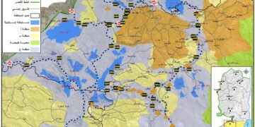
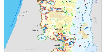
On June 2002, the Israeli Government launched its policy of unilateral segregation within the Occupied Palestinian Territory (OPT) by establishing a Segregation Zone along the western terrains of the occupied West Bank. The Western Segregation Zone is the area west of the Segregation Wall that reaches to the Green Line. The Israeli Segregation Zone covers substantial and significant land areas, rich with natural resources (water aquifers) as it runs along the western part of the West Bank from north to south, seizing the most fertile agricultural lands, isolating Palestinian communities in enclaves, undermining the territorial contiguity between the Palestinian villages and cities, controlling the natural resources, and encapsulating and protecting most of the illegal Israeli settlements. At this time, an explanation of the term “Segregation Wall” should be made obvious as it reflects two types of structures used by the Israeli Army to fulfill their territorial separation mission in the Occupied Palestinian Territory; Israel has built either 8-12 meters in height concrete partition or a multi line fence. In both cases, the term Segregation Wall applies.

Based on the characteristic nature of the area through which the Segregation Wall runs, the type of structure is determined based on whether the area is agricultural land or a densely populated village or town. The Segregation Wall as a fence cuts through vast agriculture lands.  The Segregation Fence is more devastating to the land than the 8-meter wall as it requires an area of 40-100 meters in width to complete.  Moreover, it is a double-layered fence, reinforced with barbed wires, trenches, military roads and footprint-detection tracks, and includes a 4-5 meter high electrified metal fence, equipped with security surveillance cameras. In the other case, in areas with sizeable population and/or in close proximity to the Green Line, the Segregation Wall consists of 8-12 meter high concrete partitions, with military watchtowers appendages lined-up 250 meters apart.   

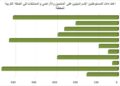
Moreover, the Wall separates 107 Israeli settlements, accommodating over 85% of the Israeli settlers’ population in the West Bank. These 107 settlements, built on confiscated Palestinian land, will be on the Israeli side of the Wall and have easy access to locations within Israel. On the other hand, 66 Palestinian localities (excluding the 30 Jerusalem localities) will be cut off from the West Bank and will not have access to Israel on the western side, thus they will be isolated in the Western Segregation Zone. The following table shows the status of the Segregation Wall in the West Bank:

Status

Length/ km

percentage

Existing

500

65

Under Construction

15.5

2

Planned

255.5

33

Total

771

100%

135 km (17.5% of the Wall's total length) runs on the 1949 Armistice Line (Green Line)


For related infograph, click HERE


Prepared by:  
The Applied Research Institute – Jerusalem


Recommended For You

سلطات الاحتلال الإسرائيلي تفرض واقعا جيوسياسيا جديدا في منطقة شمال قطاع غزة المحتل

by arij
March 13, 2024
0
سلطات الاحتلال الإسرائيلي تفرض واقعا جيوسياسيا جديدا في منطقة شمال قطاع غزة المحتل

  أظهرت صور الأقمار الصناعية الصادرة عن برنامج مراقبة الأرض التابع للاتحاد الأوروبي (كوبرنيكوس) لقطاع غزة المحتل في العاشر من شهر اذار من العام 2024، ان سلطات الاحتلال...

Read moreDetails

الحرب على قطاع غزة وتأثيرها على محافظة الخليل جنوب الضفة الغربية

by arij
November 30, 2023
0

  تقع محافظة الخليل في الجزء الجنوبي من الضفة الغربية المحتلة، إلى الجنوب من مدينة القدس، وعلى بعد حوالي 36 كم منها. يحدها من الشمال محافظة بيت لحم،...

Read moreDetails

تطبيق سياسة الفصل العنصري على استخدام الطرق الرئيسية في الضفة الغربية وتقيد حركة وتنقل المواطنين الفلسطينيين

by arij
November 22, 2023
0
معاناة شجرة الزيتون الفلسطينية بسبب الاحتلال والاستيطان في العام 2023

  بناء على تقديرات مراقبين دوليين يبلغ عدد الحواجز الإسرائيلية في الضفة الغربية أكثر من 567 حاجز إسرائيلي متعددة الاشكال منها 77 حاجزًا رئيسيًا وجزئي تتحكم في حركة...

Read moreDetails

The Instigation of Apartheid Roads Era: Israel blocks Palestinian movement inside West Bank Governorates

by arij
November 22, 2023
0

  According to international observers, Israel constrains the West Bank territory with 567 various types of obstacles; 77 of which are main checkpoints and partial checkpoints that control...

Read moreDetails

Between “Ben Gavir” and Netanyahu Not Oblivious but Vindictive, The reality of Israeli Apartheid Stands in the occupied Palestinian territory

by arij
September 13, 2023
0
Between “Ben Gavir” and Netanyahu Not Oblivious but Vindictive, The reality of Israeli Apartheid Stands in the occupied Palestinian territory

  In the wake of the overwhelming Israeli settlers and the Israeli occupation government increasing their wave of attacks and assaults on the Palestinian people (more than 700...

Read moreDetails
Next Post
The Israeli Occupation Army  close agricultural road in Qalqiliya governorate

The Israeli Occupation Army  close agricultural road in Qalqiliya governorate

LATEST NEWS

الأراضي الفلسطينية بين الذرائع الأمنية والأطماع الاستيطانية – “الأمن، الآثار، والطبيعة كحجج لاقتلاع الفلسطينيين من أراضيهم”

by arij
April 15, 2025
0

........................................................

الطرق الالتفافية الاسرائيلية وأثرها على البيئة الفلسطينية

انتهاك للطبيعة والهوية في الأراضي الفلسطينية المحتلة

by arij
March 17, 2025
0

........................................................

Israel Advances Settlement Plan on Ancient Olive Groves on lands of Beit Jala city, Violating International Law and depriving Palestinians their lands

إسرائيل تمضي قدمًا في مخطط استيطاني جديد على أراضي مدينة بيت جالا، في انتهاك للقانون الدولي وحرمان الفلسطينيين من أراضيهم

by arij
April 29, 2025
0

........................................................

Israel Advances Settlement Plan on Ancient Olive Groves on lands of Beit Jala city, Violating International Law and depriving Palestinians their lands

Israel Advances Settlement Plan on Ancient Olive Groves on lands of Beit Jala city, Violating International Law and depriving Palestinians their lands

by arij
April 29, 2025
0

........................................................

flag_yellow_lowEU-PfP-Logo

This website has been produced with the assistance of the European Union. The contents of this publication are the sole responsibility of ARIJ & LRC and can in no way be taken to reflect the views of the European Union.

© 2025 Copyright ARIJ . All Rights reserved. .

No Result
View All Result
  • Home
  • Settlements
    • New Israeli Settlements
    • Settlement Expansion
  • Israeli Violations
    • Agriculture
    • Confiscation
    • Demolition
    • Environment
    • Eviction of Palestinians
    • Settlers Attacks
  • Bypass Roads
  • Israeli Plans
  • Segregation
    • Checkpoints
    • Closure
    • Separation Plans
  • Military Orders
  • Reports
    • Daily Report
    • Monthly Report
    • Quarterly Report

© 2025 Copyright ARIJ . All Rights reserved. .